|
| Mesoscale Discussion 2126 |
|
< Previous MD Next MD >
|
|
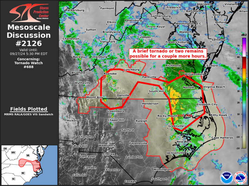
   Mesoscale Discussion 2126
   NWS Storm Prediction Center Norman OK
   0228 PM CDT Fri Sep 27 2024

   Areas affected...parts of southern VA and northern NC

   Concerning...Tornado Watch 688...

   Valid 271928Z - 272130Z

   The severe weather threat for Tornado Watch 688 continues.

   SUMMARY...A brief tornado or two will remain possible for a couple
   more hours. An additional tornado watch beyond the 22Z expiration of
   WW 688 appears unlikely.

   DISCUSSION...Tornado potential has become focused in two regions
   within WW 688, one near the northeast NC/southeast VA border area
   and a separate corridor near along the central VA/NC border. The
   lead convective band has considerably decayed over the past couple
   hours, but remnants of it continue to move northeast along the
   northeast NC/southeast VA border area. Surface temperatures and dew
   points are a couple degrees lower downstream, suggesting the threat
   will struggle to reintensify. But favorable low-level shear and
   still adequate tropical boundary-layer moisture suggest a
   conditional tornado threat remains evident.

   Farther west, multiple low-topped cells have rotated and produced at
   least one brief TDS thus far. Surface temperatures have warmed into
   the low to mid 80s within cloud breaks across central NC and this
   has compensated for the persistent reduction in low-level SRH per
   the FCX VWP. A brief tornado or two will remain possible with small
   discrete cells in this region for another couple hours.

   ..Grams.. 09/27/2024

   ...Please see www.spc.noaa.gov for graphic product...

   ATTN...WFO...AKQ...MHX...RAH...RNK...

   LAT...LON   36937599 36077590 35517682 35627713 36557731 36967770
               37097854 36287914 36197962 36448000 37198000 37477964
               37487927 37077731 37297671 36937599
|
|
Top/All Mesoscale Discussions/Forecast Products/Home
|
|


 @NWSSPC