|
| Mesoscale Discussion 2124 |
|
< Previous MD Next MD >
|
|
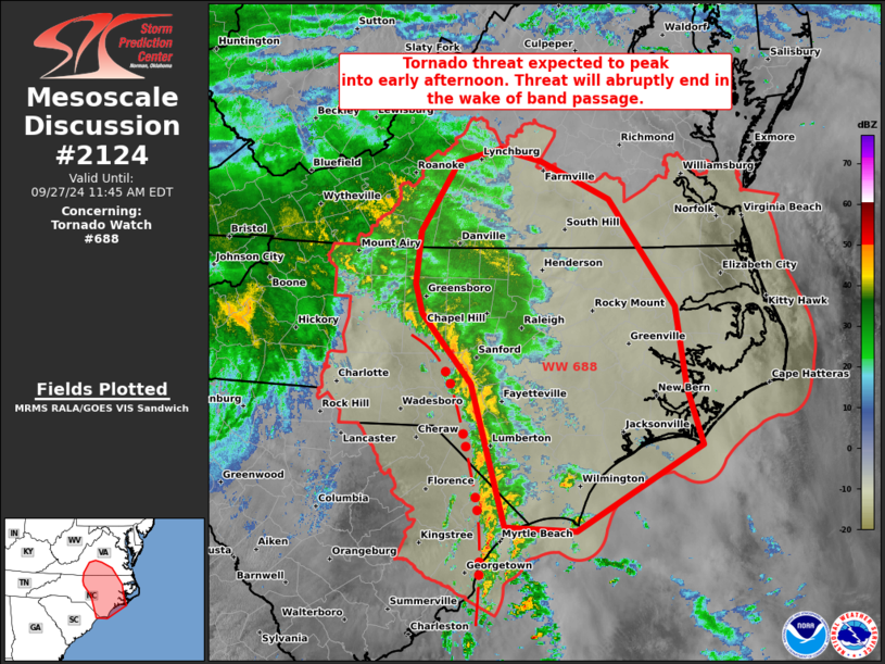
   Mesoscale Discussion 2124
   NWS Storm Prediction Center Norman OK
   0848 AM CDT Fri Sep 27 2024

   Areas affected...Southern to central/eastern NC and southern VA

   Concerning...Tornado Watch 688...

   Valid 271348Z - 271545Z

   The severe weather threat for Tornado Watch 688 continues.

   SUMMARY...Tornado threat is expected to peak into early afternoon
   across southern, eastern, and central North Carolina, into a part of
   southern Virginia. This threat will abruptly end in the wake of
   ongoing band passage associated with Tropical Storm Helene.

   DISCUSSION...Several supercells are ongoing within a roughly 300-km
   long convective band, with the inland portion approaching the
   Raleigh-Durham Metro Area and the trailing portion to along the
   NC/SC border area. Individual cells are largely transient and
   progressing north at 45-55 kts. The overall band will rapidly sweep
   across much of central and eastern North Carolina into midday before
   entering southern VA. Low-level hodographs are currently maximized,
   with 0-1 km SRH around 500-600 m2/s2 per LTX/RAX VWP data. These are
   expected to shrink during the afternoon, suggesting the tornado
   threat will wane later today. Boundary-layer heating will remain
   limited by pervasive cloud coverage downstream, but even minor
   insolation amid mid 70s surface dew points should provide enough
   boost to increase daytime tornado potential. In the wake of the
   band, substantial mid-level warming/drying will curtail additional
   development and the threat will be confined along/ahead of the
   ongoing band.

   ..Grams.. 09/27/2024

   ...Please see www.spc.noaa.gov for graphic product...

   ATTN...WFO...AKQ...MHX...RAH...ILM...RNK...

   LAT...LON   35907983 36187990 36707984 37377940 37507891 37387841
               37027759 35977679 35177666 34627648 33777797 33827883
               35217924 35907983
|
|
Top/All Mesoscale Discussions/Forecast Products/Home
|
|


 @NWSSPC