|
| Mesoscale Discussion 2118 |
|
< Previous MD Next MD >
|
|
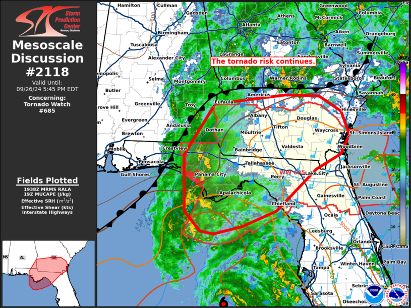
   Mesoscale Discussion 2118
   NWS Storm Prediction Center Norman OK
   0240 PM CDT Thu Sep 26 2024

   Areas affected...portions of the Florida Panhandle and southwest
   Georgia

   Concerning...Tornado Watch 685...

   Valid 261940Z - 262145Z

   The severe weather threat for Tornado Watch 685 continues.

   SUMMARY...The tornado risk continues across WW 684. The focus should
   remain close to a weak front/baroclinic zone across the FL Panhandle
   and Southwest GA.

   DISCUSSION...Ahead of Hurricane Helene located near 26.4N 85.0W or
   195 MI...315 km SW of Tampa, the environment remains favorable for a
   few tornadoes. Inland advection of a very moist tropical air mass
   continues along and east of a weak stalled frontal boundary, with
   weak buoyancy (~1000 J/kg MUCAPE) supporting numerous low-topped
   convective elements in the outer bands. Low-level hodographs have
   also continued to expand with the TLH VAD showing strong low-level
   turning and 250-350 m2/s2 o-1km SRH. As low-topped offshore cells
   with low-level rotation move northwestward near Apalachicola, a few
   tornadoes are possible. The greatest focus for tornadoes appears to
   be along and east of the boundary, where low-level shear should be
   somewhat enhanced. However, as Helene approaches later this
   afternoon, low-level shear will continue to increase, supporting a
   risk for tornadoes across much of the watch area.

   ..Lyons.. 09/26/2024

   ...Please see www.spc.noaa.gov for graphic product...

   ATTN...WFO...CHS...JAX...FFC...TAE...BMX...

   LAT...LON   30698593 31928509 32148310 32108218 31738158 31178135
               30728161 30378228 29378338 29008432 28838509 28888546
               29358589 30698593
|
|
Top/All Mesoscale Discussions/Forecast Products/Home
|
|


 @NWSSPC