|
| Mesoscale Discussion 2117 |
|
< Previous MD Next MD >
|
|
Mesoscale Discussion 2117
NWS Storm Prediction Center Norman OK
0214 PM CDT Thu Sep 26 2024
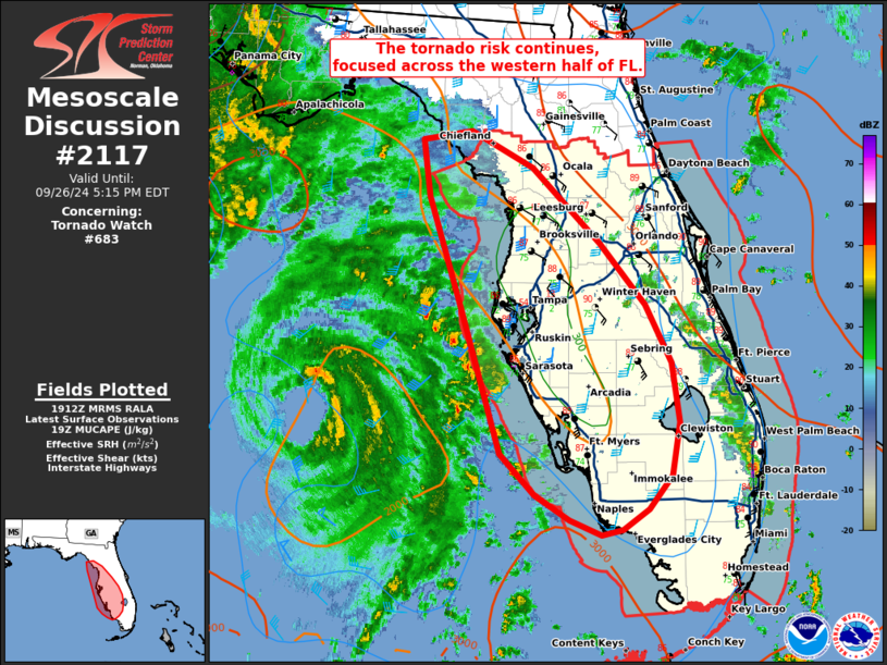
Areas affected...portions of the western Florida Peninsula
Concerning...Tornado Watch 683...
Valid 261914Z - 262115Z
The severe weather threat for Tornado Watch 683 continues.
SUMMARY...The tornado risk associated with low-topped supercells in
the bands of Helene continues across all of WW683. The greatest risk
will likely be focused over the western half of FL where low-level
shear is stronger.
DISCUSSION...As of 1915 UTC, the center of Hurricane Helene was
located near 26.4N 85.0W or about 195 MI...315 KM SW of Tampa FL per
the latest NHC information. As the outer bands of Helene continue to
move over the FL peninsula, cloud breaks between the bands were
supporting heating and weak destabilization. Several bands of
showers and low-topped thunderstorms were located off the western
Coast, with a less organized band over the central and eastern parts
of FL. Low-level shear (Tampa VAD 350-450 m2/s2 0-1km SRH) is
strongest to the west, closer to the center of the circulation.
However, low-level shear remains supportive of tornadoes over much
of FL. Given favorably strong/weakly veering low-level flow
indicated across the entire area, risk for brief tornadoes continues
with any cellular convection that evolves.
..Lyons.. 09/26/2024
...Please see www.spc.noaa.gov for graphic product...
ATTN...WFO...MFL...MLB...TBW...JAX...TAE...
LAT...LON 27978319 28978350 29498358 29578306 29238242 28548173
27968125 27438098 26878090 26388099 26078122 25898149
25848171 25988205 26208240 26588277 27978319
|
|
Top/All Mesoscale Discussions/Forecast Products/Home
|
|


 @NWSSPC