|
| Mesoscale Discussion 2116 |
|
< Previous MD Next MD >
|
|
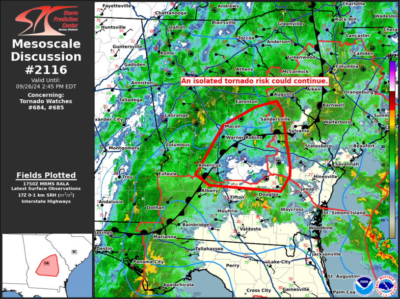
   Mesoscale Discussion 2116
   NWS Storm Prediction Center Norman OK
   1252 PM CDT Thu Sep 26 2024

   Areas affected...portions of eastern/southeastern Georgia

   Concerning...Tornado Watch 684...685...

   Valid 261752Z - 261845Z

   The severe weather threat for Tornado Watch 684, 685 continues.

   SUMMARY...Low-topped supercells have shown increased low-level
   rotation over the last few hours across southeastern/eastern GA. The
   air mass in place is not overly favorable for tornadoes in the short
   term casting some uncertainty on the longevity of the tornado
   threat. A greater tornado risk should develop later today as Helene
   approaches.

   DISCUSSION...As of 1745 UTC, regional radar imagery shows a broad
   area of stratiform precipitation and embedded convective elements
   ongoing near a stationary front across potions of southern/eastern
   GA. North of the primary outer bands of TC Helene, substantial
   precipitation has been ongoing over the past 24. Despite strong
   low-level warm air advection, the precipitation has severely limited
   diurnal destabilization this far inland. With Buoyancy less than 250
   J/kg of MUCAPE on SPC mesoanalysis, most of the convection is very
   low-topped and weak. Still, low-level hodographs have enlarged (and
   will continue to do so) through the day. This is supporting some
   tornado risk with the more robust cells in several weak bands.
   Eventually, a higher-theta E air mass should move in as the core of
   Helene approaches from the south later this afternoon/evening. This
   could support more buoyancy and a greater tornado risk.

   The primary uncertainty remains the limited buoyancy through the
   next several hours north of and west of Tornado Watch #685 and #684
   respectively. A local extension of the active watches could be
   required to cover the more uncertain short-term tornado risk.
   However, the approach of Helene will eventually support a
   longer-fused tornado threat as low-level wind fields and buoyancy
   increase substantially. For now, the risk of tornadoes appears
   lower, though trends will continue to be monitored.

   ..Lyons/Mosier.. 09/26/2024

   ...Please see www.spc.noaa.gov for graphic product...

   ATTN...WFO...CHS...CAE...JAX...FFC...TAE...

   LAT...LON   31638231 31748395 31968427 32928364 33298289 33408240
               33218227 32108210 31928211 31638231
|
|
Top/All Mesoscale Discussions/Forecast Products/Home
|
|


 @NWSSPC