|
| Mesoscale Discussion 2096 |
|
< Previous MD Next MD >
|
|
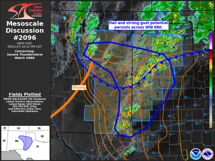
   Mesoscale Discussion 2096
   NWS Storm Prediction Center Norman OK
   0713 PM CDT Sat Sep 21 2024

   Areas affected...eastern New Mexico into western Texas

   Concerning...Severe Thunderstorm Watch 680...

   Valid 220013Z - 220315Z

   The severe weather threat for Severe Thunderstorm Watch 680
   continues.

   SUMMARY...The threat of large hail and scattered severe gusts
   continues from far eastern NM Into parts of the TX Panhandle and
   South Plains this evening.

   DISCUSSION...Surface analysis show a cold front extending from
   west-central OK into east-central NM, with a dryline punching
   northeastward across central NM. Gusty southeast winds persist
   across the warm sector over much of the South Plains and into
   southeast NM, with scattered strong to severe cells both north and
   south of the cold front.

   Around 2000 J/kg MLCAPE exists within the instability axis, as
   indicated on the 00Z MAF. Winds in the lowest few km are mostly
   unidirectional, before veering to southwesterly around 700 mb.
   Hodographs are therefore primarily straight line, with elongation in
   the mid to upper levels. While low-level shear is stronger along the
   cold front, much of this will remain ineffective due to the cooler
   air mass. However, the South Plains portion of the front is a bit
   more favorably oriented for storms to potentially interact for a
   longer duration before becoming elevated, and a brief tornado cannot
   be ruled out. Otherwise, hail appears to be the primary risk this
   evening.

   ..Jewell.. 09/22/2024

   ...Please see www.spc.noaa.gov for graphic product...

   ATTN...WFO...LUB...AMA...MAF...ABQ...

   LAT...LON   32190387 32940368 33690364 34470409 34690452 35190547
               35670523 35750420 35430237 35240148 34930115 34080093
               33340144 32260234 31850310 31910362 32190387
|
|
Top/All Mesoscale Discussions/Forecast Products/Home
|
|


 @NWSSPC