|
| Mesoscale Discussion 2095 |
|
< Previous MD Next MD >
|
|
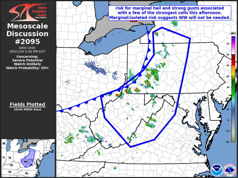
   Mesoscale Discussion 2095
   NWS Storm Prediction Center Norman OK
   0137 PM CDT Sat Sep 21 2024

   Areas affected...western New York...western
   Pennsylvania...southeastern Ohio...much of West Virginia...western
   Virginia...and the western Maryland Panhandle

   Concerning...Severe potential...Watch unlikely

   Valid 211837Z - 212100Z

   Probability of Watch Issuance...20 percent

   SUMMARY...A few strong thunderstorms briefly reaching marginal
   severe levels can be expected through this afternoon.  Marginal hail
   and tree damage can be expected locally.  However, the very
   isolated/marginal nature of the risk currently expected should
   preclude the need for WW consideration.

   DISCUSSION...A weak cool front will continue moving southeastward
   across the Mid and Upper Ohio Valley area and into the central
   Appalachians today, as a vort max near Lake Huron shifts across the
   Lower Great Lakes toward the Chesapeake Bay area this afternoon and
   tonight.

   Ahead of the front, a modestly moist boundary layer (low 60s
   dewpoints) combined with warm-sector heating is resulting in around
   1000 J/kg mixed-layer CAPE across much of the area, though into the
   1500 to 2000 J/kg range over the middle Ohio Valley portion of the
   region.  This destabilization is fueling a gradual increase in
   convective coverage and intensity near and ahead of the front --
   from southeastern Ohio to southwestern New York.

   Though low-level flow remains weak, moderate mid-level
   northwesterlies are contributing to an environment amply sheared to
   support organized updrafts.  As such, locally strong/briefly
   vigorous updrafts will likely be associated with marginal severe
   potential into early evening -- with risk spreading gradually
   eastward/southeastward with time.

   ..Goss/Guyer.. 09/21/2024

   ...Please see www.spc.noaa.gov for graphic product...

   ATTN...WFO...BGM...BUF...CTP...LWX...RNK...PBZ...RLX...

   LAT...LON   39598204 39888105 40368027 40797954 41487892 42507897
               42717843 42207672 41327693 38777771 37647890 37308026
               38618177 39598204
|
|
Top/All Mesoscale Discussions/Forecast Products/Home
|
|


 @NWSSPC