|
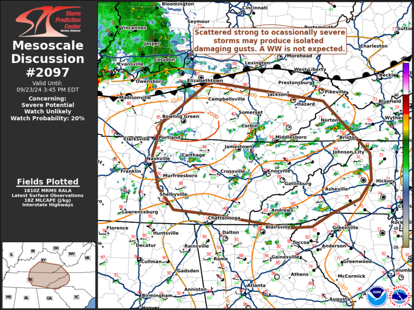
| Mesoscale Discussion 2097 |
|
< Previous MD Next MD >
|
|
   Mesoscale Discussion 2097
   NWS Storm Prediction Center Norman OK
   0113 PM CDT Mon Sep 23 2024

   Areas affected...Portions of southern Kentucky...middle/eastern
   Tennessee and far western North Carolina

   Concerning...Severe potential...Watch unlikely

   Valid 231813Z - 231945Z

   Probability of Watch Issuance...20 percent

   SUMMARY...Convection should gradually expand in coverage this
   afternoon with a few stronger multi-cell clusters possible. Isolated
   damaging winds are the most likely threat with the more
   persistent/stronger storms. Environmental conditions are not overly
   conducive for longevity or severity, a watch appears unlikely.

   DISCUSSION...As of 1810 UTC, afternoon visible and radar imagery
   showed scattered thunderstorms developing south of a stationary
   frontal zone over parts of the TN Valley and southern KY. Driven
   primarily by strong diurnal heating of a seasonably moist (upper 60s
   to low 70s F dewpoints) air mass, SPC mesoanalysis shows 1000-1500
   J/kg of MLCAPE, despite poor mid-level lapse rates. In the absence
   of significant height falls aloft, convective coverage should
   gradually increase through the afternoon with continued heating.

   As storms deepen, flow aloft will also gradually increase from the
   west. While area VADs are not overly strong, especially with
   eastward extent, 25-30 kt of flow aloft will support some potential
   for organization into multi-cell clusters. Damaging winds associated
   with water-loaded downdrafts appear to be the most likely threat
   given poor low and mid-level lapse rates and limited storm
   organization.

   Hi-res model guidance and observational trends suggest storms will
   gradually move eastward into parts of eastern TN/southeast KY and
   the western Carolinas later this afternoon/evening. An isolated risk
   for damaging winds will accompany the stronger/more persistent
   clusters. However, the lack of more significant upper-level support,
   poor lapse rates and marginal deep-layer shear suggests the threat
   is unlikely to be widespread enough to warrant a WW.

   ..Lyons/Guyer.. 09/23/2024

   ...Please see www.spc.noaa.gov for graphic product...

   ATTN...WFO...RNK...RLX...GSP...MRX...JKL...FFC...LMK...OHX...
   HUN...

   LAT...LON   37698535 36928641 36288662 35678647 35258610 35168512
               34918339 34948284 35218233 35468170 35818142 36348144
               37378254 37738517 37698535
|
|
Top/All Mesoscale Discussions/Forecast Products/Home
|
|


 @NWSSPC