|
| Mesoscale Discussion 2080 |
|
< Previous MD Next MD >
|
|
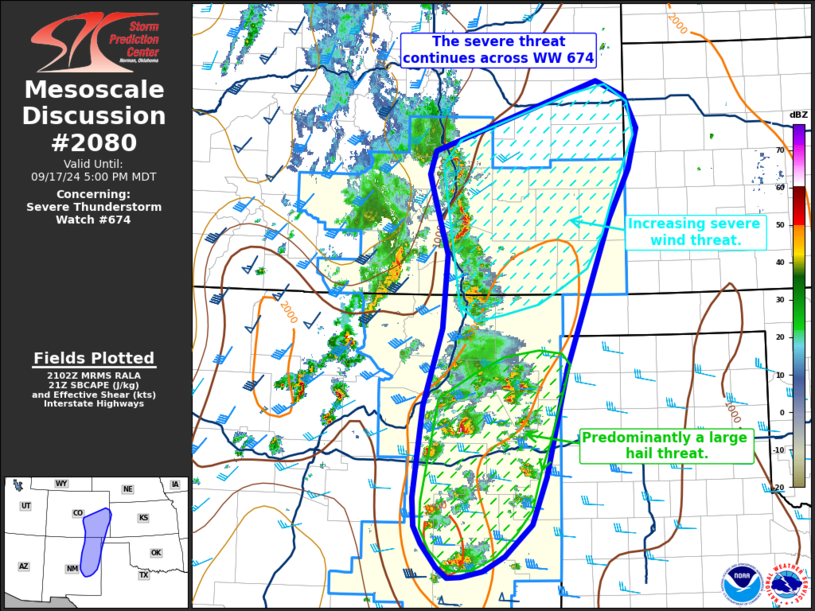
   Mesoscale Discussion 2080
   NWS Storm Prediction Center Norman OK
   0404 PM CDT Tue Sep 17 2024

   Areas affected...Southeast Colorado into eastern New Mexico

   Concerning...Severe Thunderstorm Watch 674...

   Valid 172104Z - 172300Z

   The severe weather threat for Severe Thunderstorm Watch 674
   continues.

   SUMMARY...The severe threat continues across WW 674 with an
   increasing wind threat emerging across southeast Colorado and
   predominantly a hail threat across east/northeast New Mexico.

   DISCUSSION...Large scale ascent associated with the main upper wave
   continues to overspread the central Rockies with an uptick in
   convection noted across south-central CO over the past half hour. A
   combination of orographic ascent and deep-layer shear oriented along
   the terrain/initiation zone have favored a linear storm mode with
   pockets of enhanced low-level velocity noted from the KPUX radar.
   Downstream from this developing line, MLCAPE continues to increase
   to around 1000 J/kg in conjunction with strengthening deep-layer
   shear as the mid-level jet overspreads the region. Consequently,
   further intensification of this line appears probable with a
   corresponding increase in severe wind potential downstream across
   southeast/east-central CO.

   Further south across eastern NM, more discrete storm mode has
   supported a few supercells with notable MRMS hail signatures. Weaker
   forcing for ascent and 30-45 knots of effective bulk shear should
   continue to favor discrete/semi-discrete cells with a continued risk
   for large hail for the next few hours. The eastward extent of the
   risk remains somewhat nebulous as buoyancy decreases into the TX
   Panhandle due to somewhat shallower mid-level lapse rates; however,
   convective trends will continue to be monitored.

   ..Moore.. 09/17/2024

   ...Please see www.spc.noaa.gov for graphic product...

   ATTN...WFO...GLD...AMA...PUB...BOU...ABQ...

   LAT...LON   37900229 36100294 34800325 34230345 33850386 33670417
               33600450 33600470 33730486 34010508 34220519 34550521
               35660506 36580479 37480471 38120491 38430499 38710490
               39550247 39370203 38990185 38500198 37900229
|
|
Top/All Mesoscale Discussions/Forecast Products/Home
|
|


 @NWSSPC