|
| Mesoscale Discussion 2079 |
|
< Previous MD Next MD >
|
|
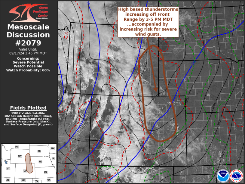
   Mesoscale Discussion 2079
   NWS Storm Prediction Center Norman OK
   0208 PM CDT Tue Sep 17 2024

   Areas affected...eastern Wyoming...northeastern/east central
   Colorado...adjacent southwestern South Dakota and western Nebraska

   Concerning...Severe potential...Watch possible

   Valid 171908Z - 172145Z

   Probability of Watch Issuance...60 percent

   SUMMARY...High-based thunderstorm development appears increasingly
   probable across and east of the Front Range by 3-5 PM MDT,
   accompanied by increasing potential for strong to severe wind gusts
   while spreading through the adjacent high plains through early
   evening.  One or two severe weather watches are possible, though
   timing remains somewhat uncertain.

   DISCUSSION...Downstream of a vigorous short wave trough pivoting
   northeastward toward the Wyoming/Colorado Rockies, southwesterly
   mid/upper flow is in the process of strengthening.  This is forecast
   to include speeds of 40-70+ kt in the 500-300 mb layer across and
   northeast of the Front Range, above a boundary layer across the high
   plains which is becoming strongly heated and deeply mixed.  Surface
   temperature/dew points already have commonly reached 40-45 degrees
   across much of eastern Colorado and Wyoming.

   While boundary-layer moisture content is generally low, various
   model output indicates that steepening lower/mid-tropospheric lapse
   rates, along the leading edge of mid-level cooling now approaching
   the Front Range, will support increasing high-based convective
   development along and east of the higher terrain by 20-22Z.
   Updrafts might not be particularly intense, at least initially as
   activity begins to spread toward the high plains, but sub-cloud
   evaporative cooling and downward mixing of cloud-bearing mean flow
   on the order of 50 kt are likely to contribute to the risk for
   strong to severe downbursts.  Thereafter, the potential for strong
   to severe wind gusts may gradually become more widespread as
   convective outflow becomes more widespread and strengthens while
   surging northeastward and eastward.

   ..Kerr/Gleason.. 09/17/2024

   ...Please see www.spc.noaa.gov for graphic product...

   ATTN...WFO...UNR...GLD...PUB...BOU...CYS...

   LAT...LON   43860453 43310377 42380364 41490341 39840284 38860290
               38430401 39050489 40020512 41470531 42270551 43080550
               43860453
|
|
Top/All Mesoscale Discussions/Forecast Products/Home
|
|


 @NWSSPC