|
| Mesoscale Discussion 2081 |
|
< Previous MD Next MD >
|
|
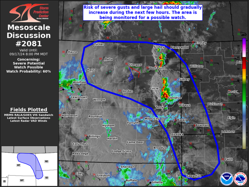
   Mesoscale Discussion 2081
   NWS Storm Prediction Center Norman OK
   0625 PM CDT Tue Sep 17 2024

   Areas affected...Portions of eastern Montana...western North
   Dakota...and northwestern South Dakota

   Concerning...Severe potential...Watch possible

   Valid 172325Z - 180200Z

   Probability of Watch Issuance...60 percent

   SUMMARY...The risk of severe wind gusts and large hail should
   gradually increase over the next few hours. The area is being
   monitored for a possible watch, though timing is still uncertain.

   DISCUSSION...A few strong to severe storms have developed along a
   north/south-oriented confluence zone across eastern MT. These storms
   are evolving in an environment characterized by around 40 kt of
   deep-layer shear (per regional VWP) and moderate surface-based
   instability -- supportive of organized clusters and supercell
   structures. Isolated large hail and severe wind gusts could
   accompany this activity.

   During the next few hours, large-scale ascent preceding an
   approaching midlevel trough may encourage an uptick in convection
   from northeastern MT into western ND and northwestern SD. Sufficient
   deep-layer shear/mostly straight hodographs and steep deep-layer
   lapse rates should favor organized clusters and supercells capable
   of severe wind gusts and large hail. The overall timing and coverage
   of the severe threat still remains somewhat uncertain, and
   convective trends are being monitored for a possible watch for parts
   of the area.

   ..Weinman/Hart.. 09/17/2024

   ...Please see www.spc.noaa.gov for graphic product...

   ATTN...WFO...BIS...UNR...BYZ...GGW...TFX...

   LAT...LON   44600402 46000472 46820548 47140652 47420795 47610861
               48260896 48790884 49020819 49010575 48900484 48720435
               48260376 46750285 45540234 44960227 44600266 44430348
               44600402
|
|
Top/All Mesoscale Discussions/Forecast Products/Home
|
|


 @NWSSPC