|
| Mesoscale Discussion 2060 |
|
< Previous MD Next MD >
|
|
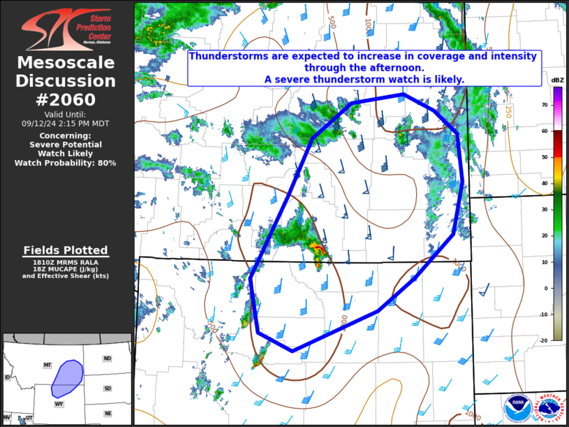
   Mesoscale Discussion 2060
   NWS Storm Prediction Center Norman OK
   0112 PM CDT Thu Sep 12 2024

   Areas affected...Northern Wyoming into eastern Montana

   Concerning...Severe potential...Watch likely

   Valid 121812Z - 122015Z

   Probability of Watch Issuance...80 percent

   SUMMARY...Organized thunderstorms are expected to increase in
   coverage and intensity through the afternoon and evening posing a
   threat of large hail and damaging wind.  A severe thunderstorm watch
   is likely in the next couple of hours.

   DISCUSSION...An upper-level jet max evident in water-vapor imagery
   is currently nosing into southern Montana.  The large-scale ascent
   associated with the approaching upper-level trough is encouraging
   early thunderstorm initiation in northern Wyoming.  Although this
   development is preceding peak diurnal heating, strong forcing is
   likely to encourage maintenance and additional development over the
   next few hours.  Continued destabilization across eastern Montana
   will result in a modestly unstable environment (~1000 J/kg MUCAPE)
   this afternoon with favorable deep-layer shear (~50 knots)
   characterized by long, straight hodographs.

   Convection-allowing models suggest that storms will initially be
   supercellular posing a threat for severe hail and isolated wind
   gusts.  Over time, the storms are expected to evolve into hybrid
   bowing clusters as they move to the north-northeast.  Eventually,
   storms are expected to grow upscale further posing a threat for
   severe winds, including the potential for significant severe gusts
   (i.e., 65 knots).  Thus, a severe thunderstorm watch is likely to
   address this threat.

   ..Jirak/Guyer.. 09/12/2024

   ...Please see www.spc.noaa.gov for graphic product...

   ATTN...WFO...UNR...BYZ...GGW...RIW...

   LAT...LON   44740870 45980793 46840743 47370657 47510543 47250477
               46900428 46190419 45410441 44760524 44270601 43650779
               43920852 44740870
|
|
Top/All Mesoscale Discussions/Forecast Products/Home
|
|


 @NWSSPC