|
| Mesoscale Discussion 2057 |
|
< Previous MD Next MD >
|
|
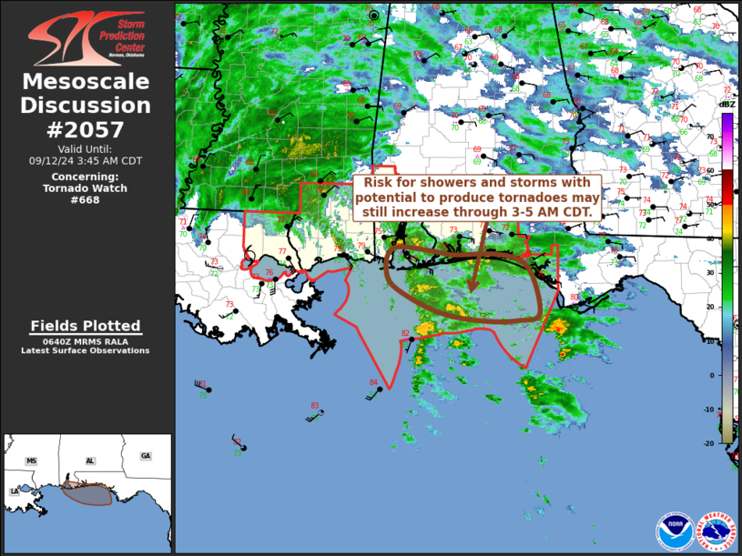
   Mesoscale Discussion 2057
   NWS Storm Prediction Center Norman OK
   0142 AM CDT Thu Sep 12 2024

   Areas affected...coastal Alabama and the western Florida Panhandle

   Concerning...Tornado Watch 668...

   Valid 120642Z - 120845Z

   The severe weather threat for Tornado Watch 668 continues.

   SUMMARY...The risk for showers and storms with potential to produce
   tornadoes may be in the process of diminishing across southeastern
   Mississippi, but it could still increase across coastal areas of the
   western Florida Panhandle and adjacent coastal Alabama through 3-5
   AM CDT.

   DISCUSSION...Rapid weakening of Francine continues, with notable
   drying circulating around its southern through southeastern
   periphery and likely to continue overspreading southeastern
   Mississippi and the Mobile Bay vicinity during the next few hours.
   The surface low is in the process of migrating near/northwest
   through north of the Lake Pontchartrain vicinity.  As the
   north-northeastward motion continues, model forecast soundings
   indicate that initially enlarged clockwise curved low-level
   hodographs across southeastern Mississippi will begin to shrink
   within the next hour or two.

   Instability associated with mid/upper 70s surface dew points is
   probably needed for stronger convection to overcome the warm
   mid-levels.  Aside from immediate coastal areas around Gulf Shores
   AL, this remains largely offshore, where a number of rotating cells
   have been evident the past few hours.  However, some inland
   advection still appears possible through daybreak across at least
   the coastal western Florida Panhandle, where low-level hodographs
   are still forecast to become sufficiently enlarged and clockwise
   curved to support at least a conditional risk for tornadoes.

   ..Kerr.. 09/12/2024

   ...Please see www.spc.noaa.gov for graphic product...

   ATTN...WFO...TAE...MOB...

   LAT...LON   29608568 29498600 29488655 29588724 29858786 30118819
               30528810 30478737 30438713 30448631 30238586 29608568
|
|
Top/All Mesoscale Discussions/Forecast Products/Home
|
|


 @NWSSPC