|
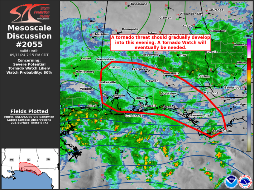
| Mesoscale Discussion 2055 |
|
< Previous MD Next MD >
|

|
   Mesoscale Discussion 2055
   NWS Storm Prediction Center Norman OK
   0340 PM CDT Wed Sep 11 2024

   Areas affected...portions of southern Alabama into the western
   Florida Panhandle

   Concerning...Severe potential...Tornado Watch likely

   Valid 112040Z - 120015Z

   Probability of Watch Issuance...80 percent

   SUMMARY...The tropical-cyclone tornado threat should gradually
   increase through the remainder of the afternoon. A Tornado Watch
   will eventually be needed.

   DISCUSSION...The center of Hurricane Francine continues to translate
   northeast as it approaches the LA coastline. Extending
   east-northeast of Francine's center is a zonal rainband, comprised
   of relatively discrete cells (some possibly transient
   supercellular). At the moment, these storms are percolating in
   intensity offshore, where a greater theta-e/buoyant airmass resides.
   However, this airmass is expected to gradually advect
   northward/inland with the north-northeastward progression of
   Francine through the afternoon and evening hours. HDC and MOB VADs
   show increasing hodograph sizes/curvature, indicating stronger
   low-level shear become established along the Gulf Coast. As such, a
   corresponding tornado threat should increase with the more favorable
   low-level warm-air/moisture advection. A Tornado Watch will
   eventually be needed.

   ..Squitieri/Guyer.. 09/11/2024

   ...Please see www.spc.noaa.gov for graphic product...

   ATTN...WFO...TAE...MOB...LIX...

   LAT...LON   29628497 29838549 30238646 30308736 30318792 30548839
               31038848 31448845 31688811 31648734 31368622 31168580
               30778518 30238464 29978456 29808453 29628497
|
|
Top/All Mesoscale Discussions/Forecast Products/Home
|
|


