|
| Mesoscale Discussion 2005 |
|
< Previous MD Next MD >
|
|
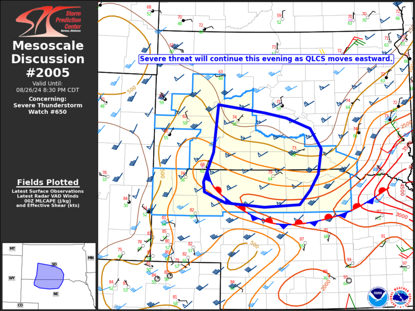
   Mesoscale Discussion 2005
   NWS Storm Prediction Center Norman OK
   0701 PM CDT Mon Aug 26 2024

   Areas affected...Southwest/south-central SD into
   northwest/north-central NE

   Concerning...Severe Thunderstorm Watch 650...

   Valid 270001Z - 270130Z

   The severe weather threat for Severe Thunderstorm Watch 650
   continues.

   SUMMARY...The threat for severe gusts, hail, and possibly a tornado
   will continue eastward through the evening.

   DISCUSSION...A QLCS with embedded supercell structures has produced
   occasional severe wind and hail reports as it moves eastward. Recent
   VWP data from KUDX suggests the presence of a rear-inflow jet, and a
   combination of sufficient instability and rather strong deep-layer
   shear will help to maintain this QLCS as it moves eastward this
   evening. Embedded supercells will remain possible along the southern
   flank of the QLCS, with some additional development possible into
   northwest/north-central NE.

   The threat for severe gusts will continue to accompany this QLCS as
   it moves eastward this evening, along with a threat of hail and
   possibly a tornado with any embedded supercells. The northern extent
   of the severe threat into central SD remains in question, due to
   cooler/more-stable conditions and stronger MLCINH in the wake of an
   outflow-reinforced surface front. This renders the need for a watch
   north of WW 650 uncertain, though some threat for strong to locally
   severe gusts cannot be ruled out into central SD, given the
   relatively organized nature of the QLCS.

   ..Dean/Gleason.. 08/27/2024

   ...Please see www.spc.noaa.gov for graphic product...

   ATTN...WFO...FSD...ABR...LBF...UNR...

   LAT...LON   44380217 44210079 44110016 43879946 43449914 42909923
               42569948 42259979 42200081 42290194 42510254 42720257
               43370230 44380217
|
|
Top/All Mesoscale Discussions/Forecast Products/Home
|
|


 @NWSSPC