|
| Mesoscale Discussion 2004 |
|
< Previous MD Next MD >
|
|
Mesoscale Discussion 2004
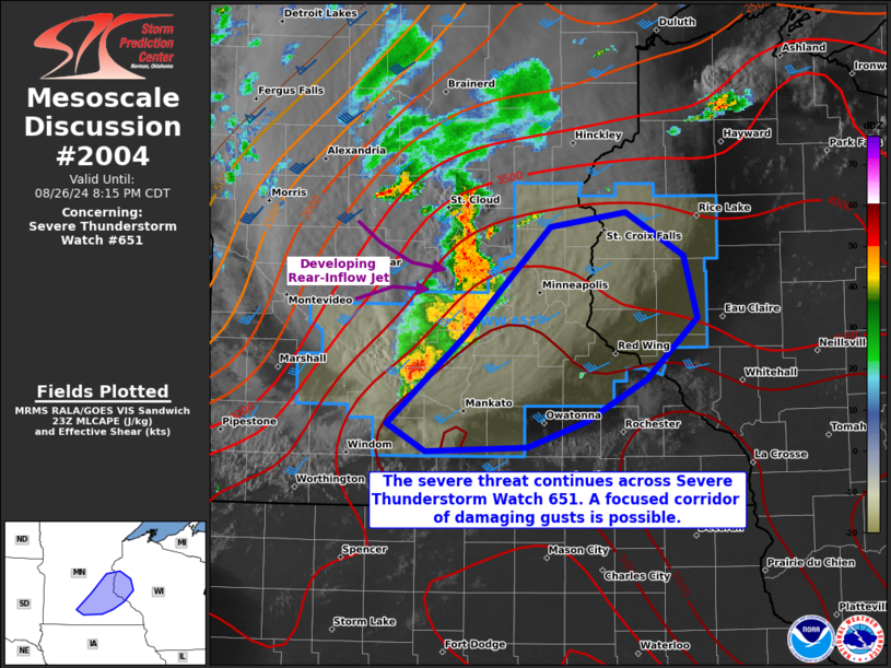
NWS Storm Prediction Center Norman OK
0644 PM CDT Mon Aug 26 2024
Areas affected...portions of eastern Minnesota into western
Wisconsin
Concerning...Severe Thunderstorm Watch 651...
Valid 262344Z - 270115Z
The severe weather threat for Severe Thunderstorm Watch 651
continues.
SUMMARY...The severe threat continues across Severe Thunderstorm
Watch 651. A bow echo MCS may develop soon and produce a focused
corridor of severe wind gusts.
DISCUSSION...Multiple HP supercells have merged over the past hour
into an MCS, with KMPX radar data showing more low-level outflow
along the leading edge of these storms. Both KMPX and MRMS mosaic
radar imagery show some bowing structure to this MCS, with
cross-sections of KMPX velocity data showing a possible rear-inflow
jet becoming established in the MCS's trailing precipitation region.
This MCS is poised to track eastward along a buoyancy gradient
delineating a modestly vs. extremely unstable environment. Low-level
shear is weak to modest at best ahead of this MCS, so it is unclear
if an intense bow echo can become established. Nonetheless, given
extreme buoyancy, at least some bow echo organization is likely over
the next couple of hours, accompanied by a severe gust threat. A
focused corridor of damaging winds cannot be ruled out, and a couple
of the stronger gusts may reach or exceed 75 mph.
..Squitieri.. 08/26/2024
...Please see www.spc.noaa.gov for graphic product...
ATTN...WFO...ARX...MPX...
LAT...LON 44079473 44699396 45429316 45529242 45239186 44799174
44379222 44089281 43909337 43889435 44079473
|
|
Top/All Mesoscale Discussions/Forecast Products/Home
|
|


 @NWSSPC