|
| Mesoscale Discussion 2003 |
|
< Previous MD Next MD >
|
|
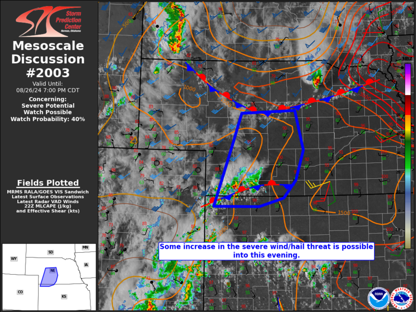
   Mesoscale Discussion 2003
   NWS Storm Prediction Center Norman OK
   0528 PM CDT Mon Aug 26 2024

   Areas affected...Parts of western/central NE into northwest KS

   Concerning...Severe potential...Watch possible

   Valid 262228Z - 270000Z

   Probability of Watch Issuance...40 percent

   SUMMARY...Some increase in the severe wind/hail threat is possible
   into the early evening.

   DISCUSSION...Some increase in storm intensity has been noted over
   the last hour over far southwest NE, in the vicinity of a weak
   surface boundary. In the immediate vicinity of the boundary, MLCAPE
   of 1000-1500 J/kg and effective shear of 30-40 kt will support
   organized convection, with a threat of isolated hail and localized
   strong/severe gusts.

   The evolution of this convection into the early evening remains
   somewhat uncertain. While some MLCINH is present into parts of
   west-central NE, there is potential for ongoing convection to spread
   northeastward with time, especially if stronger outflow can become
   established. Should this occur, some threat for strong/severe gusts
   and hail could persist into the evening.

   Isolated storm development also remains possible along an
   outflow-reinforced front that has sagged into north-central NE, to
   the south of WW 650. Favorable instability and deep-layer shear will
   support a conditional severe hail/wind risk with any development in
   this area.

   Observational trends will be monitored regarding the need for watch
   issuance across this region.

   ..Dean/Gleason.. 08/26/2024

   ...Please see www.spc.noaa.gov for graphic product...

   ATTN...WFO...GID...LBF...GLD...

   LAT...LON   39770180 41170125 41840101 41899944 41029920 40359943
               39969978 39760049 39770180
|
|
Top/All Mesoscale Discussions/Forecast Products/Home
|
|


 @NWSSPC