|
| Mesoscale Discussion 2002 |
|
< Previous MD Next MD >
|
|
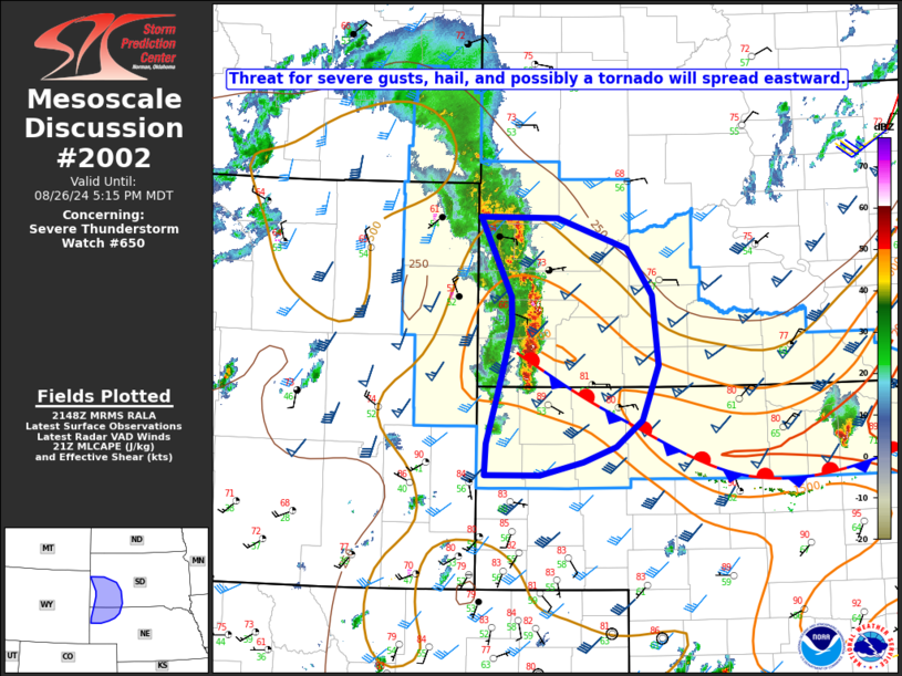
   Mesoscale Discussion 2002
   NWS Storm Prediction Center Norman OK
   0451 PM CDT Mon Aug 26 2024

   Areas affected...Western SD into the northern NE Panhandle

   Concerning...Severe Thunderstorm Watch 650...

   Valid 262151Z - 262315Z

   The severe weather threat for Severe Thunderstorm Watch 650
   continues.

   SUMMARY...Threat for severe gusts, hail, and possibly a tornado will
   spread eastward through late afternoon.

   DISCUSSION...A storm cluster is becoming increasingly well organized
   this afternoon from the Black Hills vicinity to near the NE/SD
   border, immediately in advance of a seasonably strong shortwave
   trough moving across northern WY/southern MT. While the mode has
   already become primarily linear, MLCAPE of 500-1500 J/kg (greater
   with southward extent) and strong deep-layer shear will continue to
   support embedded supercell structures.

   As this developing QLCS moves eastward, it will be accompanied by a
   threat of severe gusts, with some increasing threat for significant
   gusts (greater than 75 mph) if continued upscale growth occurs. Hail
   (locally in excess of 2 inches in diameter) and possibly a tornado
   will also be possible with embedded supercells, especially along the
   southern portion of the QLCS, where instability is stronger and the
   line will intersect a nearly stationary surface boundary near the
   NE/SD border.

   ..Dean.. 08/26/2024

   ...Please see www.spc.noaa.gov for graphic product...

   ATTN...WFO...LBF...UNR...CYS...

   LAT...LON   44670401 44650297 44350204 43900170 43210161 42670184
               42400218 42260262 42130320 42120394 42430392 42960376
               43300366 43610359 43890360 44670401
|
|
Top/All Mesoscale Discussions/Forecast Products/Home
|
|


 @NWSSPC