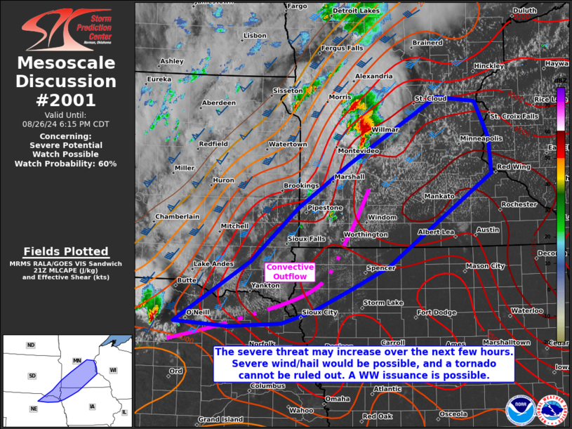
   Mesoscale Discussion 2001
   NWS Storm Prediction Center Norman OK
   0439 PM CDT Mon Aug 26 2024

   Areas affected...portions of far northeast Nebraska...southeast
   South Dakota...southwest to central Minnesota...northwest Iowa

   Concerning...Severe potential...Watch possible

   Valid 262139Z - 262315Z

   Probability of Watch Issuance...60 percent

   SUMMARY...The severe threat may increase over the next few hours.
   Severe wind and hail would be the main threats, though a couple of
   tornadoes could not be ruled out. Convective trends are being
   monitored for the need of a WW issuance.

   DISCUSSION...Convective outflow from earlier storms has sagged
   southeast along the periphery of strong to extreme instability
   (characterized by 4000-5000 J/kg MLCAPE), but modest remaining
   MLCINH. Forcing along this baroclinic boundary is not overly strong,
   yet satellite and MRMS mosaic radar data depict attempts at
   convective initiation just east of the SD/MN over the past hour or
   so. Should storms develop, mature, and sustain themselves, 30-40 kts
   of effective bulk shear overlapping this extreme instability will
   support initial supercell structures with significant severe wind
   and hail a concern. Given the extreme buoyancy and presence of one
   or more boundaries, a couple of tornadoes also cannot be ruled out
   if supercells can anchor on the boundary and ingest locally higher
   SRH. If storms develop and cold pool mergers occur, bowing segments
   capable of producing focused corridors of severe gusts is also
   possible.

   Nonetheless, given weak forcing, it is unclear if storms can become
   sustained and more widespread. Convective trends will continue to be
   monitored for the need of a WW issuance.

   ..Squitieri/Gleason.. 08/26/2024

   ...Please see www.spc.noaa.gov for graphic product...

   ATTN...WFO...MPX...DMX...FSD...OAX...LBF...

   LAT...LON   42419887 43299739 44069647 44709545 45649370 45579293
               45079266 44549261 43229466 42919535 42579616 42409678
               42349781 42419887
|


 @NWSSPC