|
| Mesoscale Discussion 1970 |
|
< Previous MD Next MD >
|
|
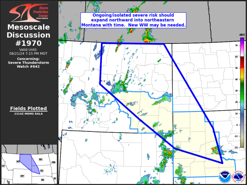
   Mesoscale Discussion 1970
   NWS Storm Prediction Center Norman OK
   0616 PM CDT Wed Aug 21 2024

   Areas affected...eastern Montana...western North
   Dakota...northeastern Wyoming...and parts of western South Dakota

   Concerning...Severe Thunderstorm Watch 642...

   Valid 212316Z - 220115Z

   The severe weather threat for Severe Thunderstorm Watch 642
   continues.

   SUMMARY...Isolated severe risk -- ongoing in/near WW 642 -- is
   forecast to expand across northeastern Montana over the next couple
   of hours.

   DISCUSSION...Latest radar/satellite loops show isolated convection
   -- rather slow to initiate thus far -- increasing across portions of
   the northeastern Wyoming vicinity.  While a couple of strong/severe
   storms persist east of the Black Hills, the aforementioned
   convection increasing over northeastern Wyoming should continue to
   increase, and spread into WW 642 with time.

   Meanwhile, a minor increase in convection over the past half hour is
   noted over portions of eastern Montana, in the wake of prior storms
   which have moved across the border into Saskatchewan.  Recent HRRR
   runs continue to show robust convective development across eastern
   Montana, as a mid-level short-wave trough now over southern Alberta
   and western Montana advances slowly east-northeastward.  With a
   favorably unstable airmass in place (mixed-layer CAPE in the 2000 to
   3000 J/kg range across east-central and northeastern Montana and
   into western North Dakota), and moderately strong/increasing flow
   with height that should strengthen with time with the approach of
   the mid-level system, the environment within and north/northeast of
   WW 642 suggests severe potential will persist well into this
   evening.  New WW issuance into portions of northeastern Montana and
   possibly western North Dakota, currently not included within WW 642,
   will likely be required within the next 1 to 2 hours.

   ..Goss.. 08/21/2024

   ...Please see www.spc.noaa.gov for graphic product...

   ATTN...WFO...ABR...BIS...UNR...BYZ...GGW...TFX...

   LAT...LON   48970877 48970458 48350405 45170149 43580099 44290392
               45570612 47130877 48970877
|
|
Top/All Mesoscale Discussions/Forecast Products/Home
|
|


 @NWSSPC