|
| Mesoscale Discussion 1971 |
|
< Previous MD Next MD >
|

|
   Mesoscale Discussion 1971
   NWS Storm Prediction Center Norman OK
   0853 PM CDT Wed Aug 21 2024

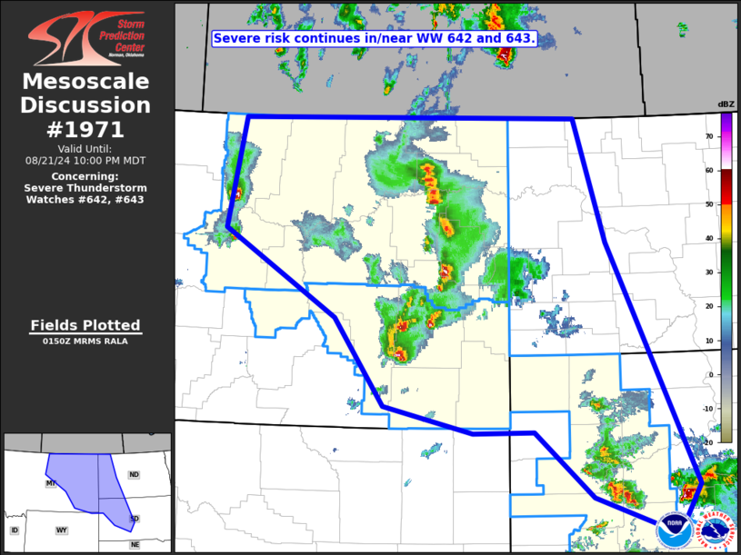
   Areas affected...eastern Montana southeastward to central South
   Dakota...and into western North Dakota

   Concerning...Severe Thunderstorm Watch 642...643...

   Valid 220153Z - 220400Z

   The severe weather threat for Severe Thunderstorm Watch 642, 643
   continues.

   SUMMARY...Severe risk -- including potential for large hail and
   damaging gusts -- continues across the northern High Plains
   vicinity.

   DISCUSSION...Latest radar composite loop across the northern High
   Plains region shows clusters of strong/severe storms moving
   east-northeastward, within a favorably unstable/sheared environment.
    While hail and damaging gusts are possible with any of the stronger
   storms, convection appears to be evolving into a semi-organized band
   across northeastern Montana.  This cluster bears watching, as
   continued organization/intensification could result in the storms
   becoming sufficiently long-lived to bring risk for severe weather
   east of WW 643 into western North Dakota over the next couple of
   hours.  This could require downstream WW consideration.

   ..Goss.. 08/22/2024

   ...Please see www.spc.noaa.gov for graphic product...

   ATTN...WFO...ABR...BIS...UNR...BYZ...GGW...TFX...

   LAT...LON   48970909 48990278 47380222 44230058 43580099 44070251
               44930360 44920473 45280638 46420731 47540940 48970909
|
|
Top/All Mesoscale Discussions/Forecast Products/Home
|
|


