|
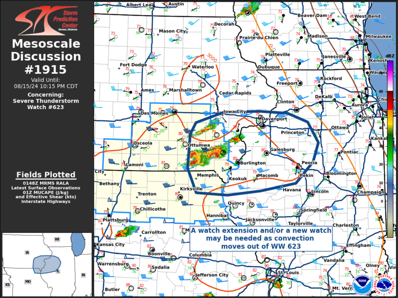
| Mesoscale Discussion 1915 |
|
< Previous MD Next MD >
|

|
   Mesoscale Discussion 1915
   NWS Storm Prediction Center Norman OK
   0851 PM CDT Thu Aug 15 2024

   Areas affected...Southeastern Iowa and northeastern Missouri...into
   western Illinois

   Concerning...Severe Thunderstorm Watch 623...

   Valid 160151Z - 160315Z

   The severe weather threat for Severe Thunderstorm Watch 623
   continues.

   SUMMARY...A local extension of WW 623, and perhaps a new downstream
   watch, may be needed as convection crosses the Mississippi River
   into Illinois.

   DISCUSSION...Despite some stabilization of the nocturnal boundary
   layer, a loosely organized cluster of thunderstorms in southeastern
   Iowa has maintained its intensity in an environment with > 3000 J/kg
   MUCAPE and deep-layer shear of 35-40 kts. The environment downstream
   will likely continue to support these storms well after dark, with
   additional upscale growth and organization not out of the question.
   The primary threat is for damaging winds, especially if upscale
   growth and subsequent leading-edge outflow develops, though some
   uncertainty remains in whether this will occur.

   ..Halbert/Squitieri.. 08/16/2024

   ...Please see www.spc.noaa.gov for graphic product...

   ATTN...WFO...LOT...ILX...LSX...DVN...DMX...EAX...

   LAT...LON   40189215 40659237 41299233 41519218 41719149 41729060
               41698989 41528939 41138913 40768927 40368971 40229057
               40159139 40189215
|
|
Top/All Mesoscale Discussions/Forecast Products/Home
|
|


