|
| Mesoscale Discussion 1853 |
|
< Previous MD Next MD >
|

|
   Mesoscale Discussion 1853
   NWS Storm Prediction Center Norman OK
   0956 PM CDT Tue Aug 06 2024

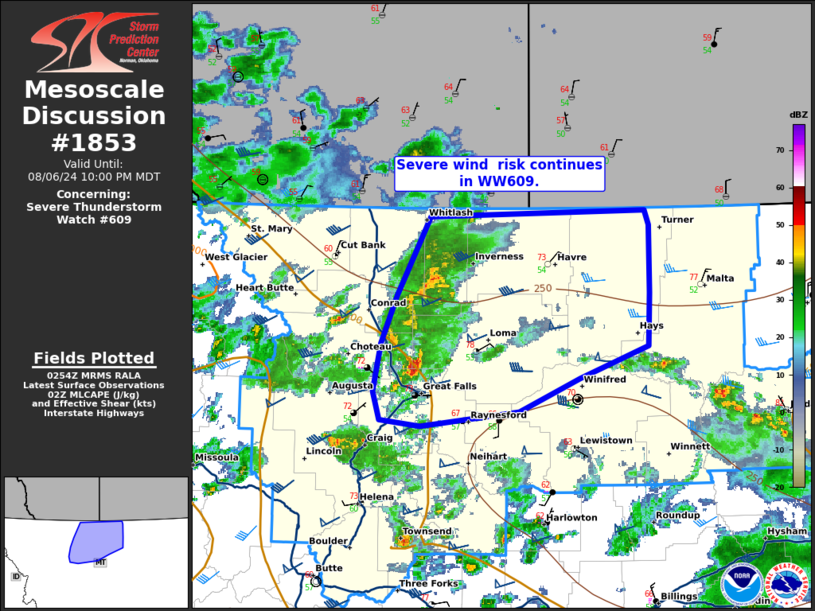
   Areas affected...north-central Montana

   Concerning...Severe Thunderstorm Watch 609...

   Valid 070256Z - 070400Z

   The severe weather threat for Severe Thunderstorm Watch 609
   continues.

   SUMMARY...Damaging wind threat continues in WW609.

   DISCUSSION...A cluster of storms across northern Montana continues
   eastward, with a trend toward more linear storm mode. This will
   support increasing potential for strong to severe gusts. Radar from
   Great Falls (KTFX) shows an increase in winds 45-55 mph around 1 kft
   within the line northwest of Great Falls, with an increase in
   lightning activity over the last 30 minutes. Though the downstream
   environment is characterized as weakly unstable (MLCAPE around 250
   J/kg), strong deep layer shear around 45-50 kts could continue to
   support a few organized segments with potential for strong to severe
   gusts.

   ..Thornton.. 08/07/2024

   ...Please see www.spc.noaa.gov for graphic product...

   ATTN...WFO...GGW...TFX...

   LAT...LON   48921120 48291160 47901178 47511188 47281179 47221131
               47341011 47620938 47880856 48310853 48850853 48980858
               48921120
|
|
Top/All Mesoscale Discussions/Forecast Products/Home
|
|


