|
| Mesoscale Discussion 1738 |
|
< Previous MD Next MD >
|

|
   Mesoscale Discussion 1738
   NWS Storm Prediction Center Norman OK
   0145 AM CDT Tue Jul 30 2024

   Areas affected...Western to south-central IA

   Concerning...Severe Thunderstorm Watch 565...

   Valid 300645Z - 300745Z

   The severe weather threat for Severe Thunderstorm Watch 565
   continues.

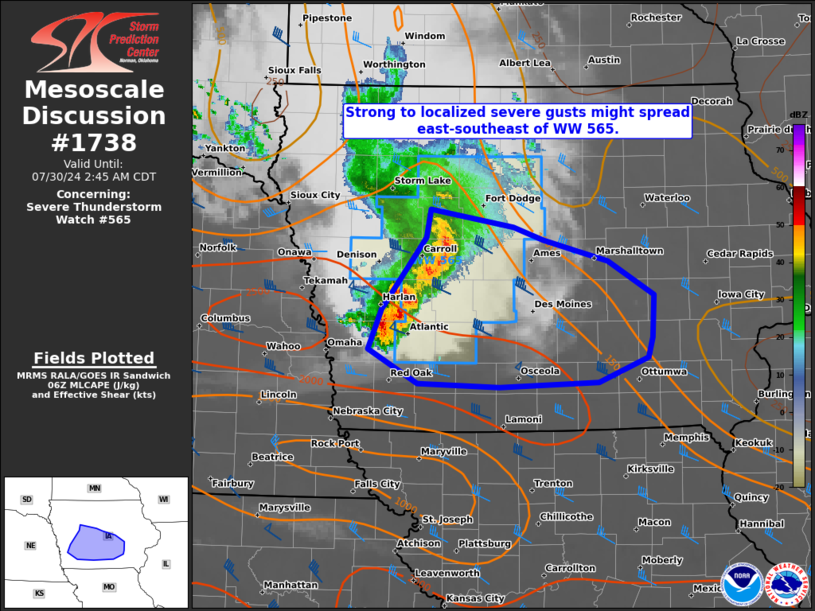
   SUMMARY...Strong to localized severe gusts may spread east-southeast
   of WW 565 with approach of a short-line segment over
   west-central/southwest Iowa. An extension of the watch in area has
   been coordinated.

   DISCUSSION...A short-line segment which produced several measured
   severe wind gusts of 60-70 mph closer to the MO Valley, has appeared
   to weaken slightly over the past hour. Still, it has produced a few
   measured wind gusts of 50-60 mph, and similar intensity may persist
   east-southeastward as the segment approaches the I-35 corridor in
   central/south-central IA. Longevity of the strong to severe wind
   threat is uncertain as the line segment and associated MCV progress
   towards eastern IA. The presence of the MLCAPE gradient should
   maintain stronger gust potential in the near-term, but relatively
   weak low-level flow (with the low-level jet well to the southwest in
   KS) may yield a gradual diminishing trend towards dawn.

   ..Grams.. 07/30/2024

   ...Please see www.spc.noaa.gov for graphic product...

   ATTN...WFO...DVN...DMX...OAX...

   LAT...LON   42469476 42309381 42199347 42029274 41739223 41369225
               41209229 40999285 40959398 40979490 41279545 41609531
               42219481 42469476
|
|
Top/All Mesoscale Discussions/Forecast Products/Home
|
|


