|
| Mesoscale Discussion 1739 |
|
< Previous MD Next MD >
|

|
   Mesoscale Discussion 1739
   NWS Storm Prediction Center Norman OK
   0407 AM CDT Tue Jul 30 2024

   Areas affected...southeast IA...far northeast MO...and far
   west-central IL

   Concerning...Severe Thunderstorm Watch 566...

   Valid 300907Z - 301030Z

   The severe weather threat for Severe Thunderstorm Watch 566
   continues.

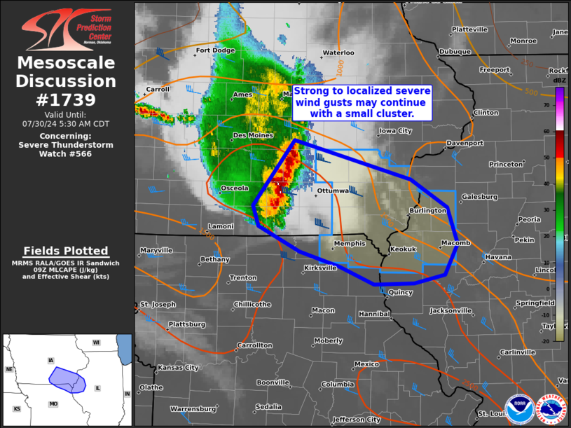
   SUMMARY...A long-lived cluster moving into southeast Iowa and
   adjacent portions of Missouri/Illinois may continue to produce
   strong to localized severe gusts into mid-morning. A downstream
   severe thunderstorm watch was recently coordinated with WFO DVN.

   DISCUSSION...An organized cluster/short-line segment has
   sporadically produced severe wind gusts to around 65 mph in the Des
   Moines and Chariton areas over the past couple hours. While cloud
   tops have warmed and the northern portion of the cluster has
   diminished, its evolution along the MLCAPE gradient has likely aided
   in maintaining its organized character. Time-series of DMX VWP data
   indicate a sustained 50-55 kt rear-inflow jet on the backside of the
   cluster. A general east-southeastward movement is anticipated over
   the next few hours across southeast IA into far west-central IL and
   far northeast MO.

   ..Grams.. 07/30/2024

   ...Please see www.spc.noaa.gov for graphic product...

   ATTN...WFO...ILX...LSX...DVN...DMX...EAX...

   LAT...LON   41619271 41199106 40889056 40499041 40179060 40089102
               40069159 40269207 40419263 40699321 40919328 41619271
|
|
Top/All Mesoscale Discussions/Forecast Products/Home
|
|


