|
| Mesoscale Discussion 1731 |
|
< Previous MD Next MD >
|

|
   Mesoscale Discussion 1731
   NWS Storm Prediction Center Norman OK
   0649 PM CDT Mon Jul 29 2024

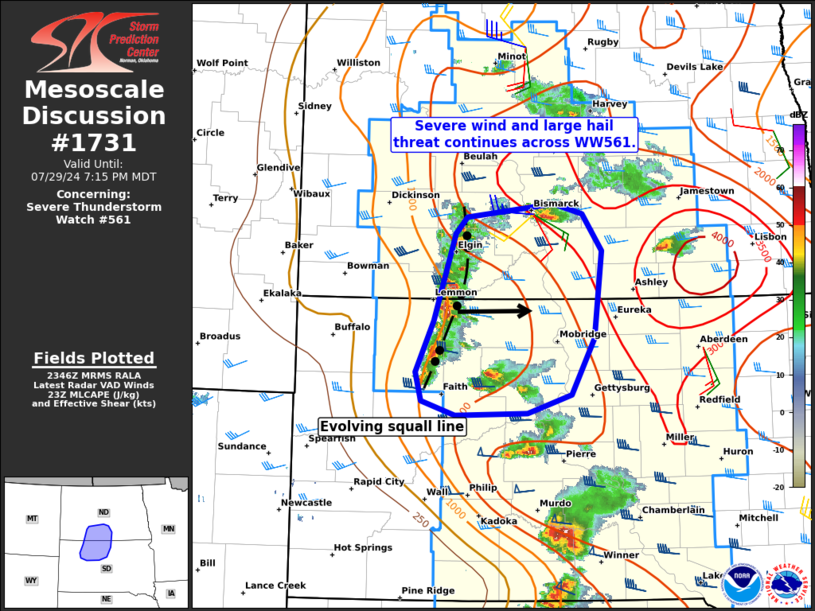
   Areas affected...Portions of south-central North Dakota and
   north-central South Dakota

   Concerning...Severe Thunderstorm Watch 561...

   Valid 292349Z - 300115Z

   The severe weather threat for Severe Thunderstorm Watch 561
   continues.

   SUMMARY...Severe wind gusts and large hail remain possible across
   Severe Thunderstorm Watch 561.

   DISCUSSION...A north/south-oriented broken line segment has shown
   signs of recent intensification across portions of northwestern SD
   into southwestern ND as of 2340Z -- with several deep/embedded
   rotating cores along the consolidating cold pool. Over the next hour
   or so, this trend may continue as the convective line continues
   eastward. This will be aided by moderate surface-based
   pre-convective instability (increasing with eastward extent) and
   around 40 kt of 0-6 km shear (per KBIS VWP) with a favorable
   line-normal component to the gust front. Given steep deep-layer
   lapse rates ahead of the line, severe gusts upwards of 65-75 mph
   will be possible, along with isolated large hail. Ahead of the line,
   a more discrete supercell mode persists, and these storms will pose
   the greater risk of large to very large hail in the near-term.

   ..Weinman.. 07/29/2024

   ...Please see www.spc.noaa.gov for graphic product...

   ATTN...WFO...ABR...BIS...UNR...

   LAT...LON   45220239 45730213 46580183 46740168 46860046 46760006
               46419980 45559991 45000037 44830083 44810183 44950230
               45220239
|
|
Top/All Mesoscale Discussions/Forecast Products/Home
|
|


