|
| Mesoscale Discussion 1732 |
|
< Previous MD Next MD >
|

|
   Mesoscale Discussion 1732
   NWS Storm Prediction Center Norman OK
   0756 PM CDT Mon Jul 29 2024

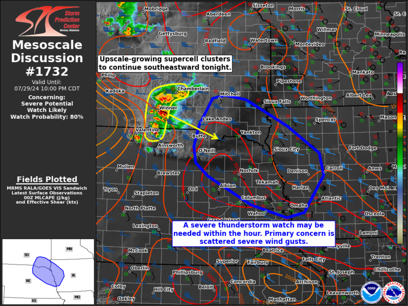
   Areas affected...Parts of southeastern South Dakota...northeastern
   Nebraska...and western Iowa

   Concerning...Severe potential...Watch likely

   Valid 300056Z - 300300Z

   Probability of Watch Issuance...80 percent

   SUMMARY...Severe thunderstorms currently over south-central South
   Dakota should continue tracking southeastward across northeastern
   Nebraska, southeastern South Dakota, and western Iowa tonight.
   Scattered severe wind gusts and large hail will be possible. A watch
   may be needed for parts of the area within the hour or so.

   DISCUSSION...An intense supercell cluster with a history of
   producing severe wind gusts over south-central SD (recently measured
   84 mph gust in Tripp County, SD) is merging with other severe storms
   in its immediate vicinity. This trend of upscale growth may continue
   over the next few hours, as these storms continue tracking
   southeastward amid a gradually strengthening low-level jet. Ahead of
   the storms, a northwest/southeast corridor of 3000-3500 J/kg MLCAPE
   is in place, as well as 40-50 kt of effective shear oriented
   perpendicular to the evolving/upscale-growing cold pool. These
   factors should support the maintenance or intensification of an
   upscale-growing cluster of severe storms, capable of producing
   scattered severe wind gusts (60-80 mph) and instances of large hail.
   While generally weak large-scale ascent casts some uncertainty on
   this scenario (especially with southeastward extent), the overall
   setup seems to likely warrant a watch for parts of the area within
   the hour or so.

   ..Weinman/Hart.. 07/30/2024

   ...Please see www.spc.noaa.gov for graphic product...

   ATTN...WFO...DMX...FSD...OAX...LBF...

   LAT...LON   42639875 43109861 43689822 43769783 43669721 43089596
               42479502 41999490 41169549 41069600 41359706 41979833
               42269869 42639875
|
|
Top/All Mesoscale Discussions/Forecast Products/Home
|
|


