|
| Mesoscale Discussion 1730 |
|
< Previous MD Next MD >
|

|
   Mesoscale Discussion 1730
   NWS Storm Prediction Center Norman OK
   0609 PM CDT Mon Jul 29 2024

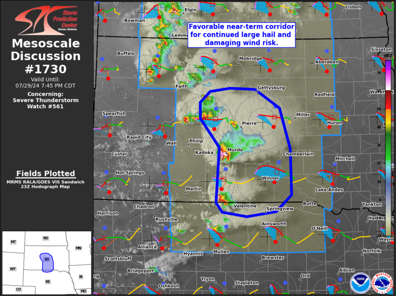
   Areas affected...Portions of central/southern South Dakota and far
   north-central Nebraska

   Concerning...Severe Thunderstorm Watch 561...

   Valid 292309Z - 300045Z

   The severe weather threat for Severe Thunderstorm Watch 561
   continues.

   SUMMARY...Large to very large hail and severe wind gusts will
   continue with the most intense thunderstorms across Severe
   Thunderstorm Watch 561.

   DISCUSSION...Latest radar data from KUDX indicates semi-discrete,
   splitting supercells generally tracking eastward across
   central/southern SD into far north-central NE this evening. These
   storms have been producing 60-65 mph gusts and hail up to 1.75
   inches. Moderately unstable surface-based inflow -- characterized by
   upper 80s/lower 90s temperatures amid upper 60s/lower 70s dewpoints
   should support the maintenance or even intensification of these
   storms with eastward extent. Long/mostly straight hodographs (with
   some low-level clockwise curvature) should favor a continuation of
   splitting, semi-discrete supercells in the near-term. These storms
   will be capable of producing locally severe gusts near 75 mph and
   very large hail to around 2.5 inches in diameter. In the near-term,
   this is especially the case with a dominant right-mover supercell
   cluster moving across portions of Jones and Mellette Counties, SD.
   While less  certain, the aforementioned hodograph structure and
   semi-discrete supercell mode may support a brief tornado as well.

   With time, there may be a tendency for some of these storms to grow
   upscale as they intercept the richer boundary-layer moisture with
   eastward extent. This would favor an increasing damaging-wind risk.

   ..Weinman.. 07/29/2024

   ...Please see www.spc.noaa.gov for graphic product...

   ATTN...WFO...FSD...ABR...LBF...UNR...

   LAT...LON   43980089 44500137 44790137 45000113 45050062 45040000
               44699938 43969912 43129909 42839948 42730020 42810080
               42980096 43980089
|
|
Top/All Mesoscale Discussions/Forecast Products/Home
|
|


