|
| Mesoscale Discussion 1729 |
|
< Previous MD Next MD >
|

|
   Mesoscale Discussion 1729
   NWS Storm Prediction Center Norman OK
   0358 PM CDT Mon Jul 29 2024

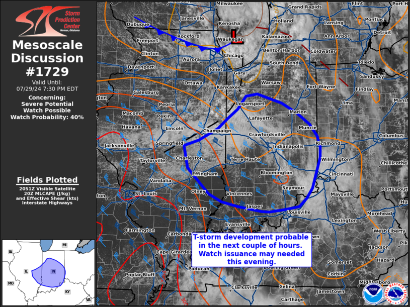
   Areas affected...eastern Illinois into central Indiana

   Concerning...Severe potential...Watch possible

   Valid 292058Z - 292330Z

   Probability of Watch Issuance...40 percent

   SUMMARY...Thunderstorm development appears probable in the next 1-2
   hours across eastern Illinois and far western Indiana. Watch
   issuance may be needed later this evening if robust supercells
   and/or an organized line can be established.

   DISCUSSION...GOES visible imagery shows slowly building cumulus
   along a diffuse trough axis to the south of a weak surface
   low/remnant MCV. Air mass recovery continues to the east of the
   trough axis with temperatures climbing into the low to mid 80s with
   dewpoints climbing well into the 70s. This is promoting a gradual
   expansion of MLCAPE values to the northeast with values ranging from
   500-2000 J/kg from southern lower MI southward into southern IL/IN.
   The expectation is for thunderstorm development in the next couple
   of hours along the trough axis as the air mass continues to
   destabilize. 30-45 knot northwesterly mid-level winds on the
   southern periphery of the MCV combined with northerly surface winds
   are supporting effective bulk shear values near 40-50 knots nearly
   orthogonal to the trough axis. This may support a few initially
   discrete cells with an attendant large hail threat. With time
   upscale growth into an organized MCS appears likely given weaker
   wind shear near the low, which will favor thunderstorm clustering
   before storms propagate southward along the buoyancy gradient into
   the better deep-layer wind shear. As such, the potential for severe
   winds may increase later this evening across eastern IL into central
   and southern IN, and possibly into the lower OH River Valley.
   Convective trends will be monitored, and watch issuance may be
   needed to address this concern.

   ..Moore/Hart.. 07/29/2024

   ...Please see www.spc.noaa.gov for graphic product...

   ATTN...WFO...ILN...LMK...IWX...IND...PAH...LOT...ILX...

   LAT...LON   39858876 39988833 40258776 40498747 40698718 41008693
               41048659 40968627 40848585 40618540 40358502 40088481
               39818472 39578472 38888497 38648513 38468535 38398573
               38348623 38358646 38468713 38578763 38758801 39048834
               39348864 39858876
|
|
Top/All Mesoscale Discussions/Forecast Products/Home
|
|


