ZCZC SPCFWDDY2 ALL
FNUS22 KWNS 021955
Day 2 Fire Weather Outlook
NWS Storm Prediction Center Norman OK
0255 PM CDT Wed Apr 02 2025
Valid 031200Z - 041200Z
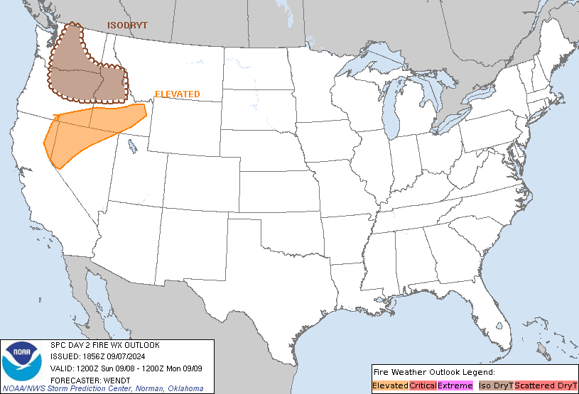
Dry, breezy conditions are still anticipated under deep-layer
southwesterly flow across portions of southwestern New Mexico into
the southern High Plains. Given forecast antecedent light rainfall
across portions of western Texas and the Panhandle, and uncertainty
in eastward extent of dryline mixing, some trimming of the Elevated
fire weather highlights were made. Latest model guidance consensus
also supports a slight westward expansion of Elevated conditions
into central New Mexico within a dry fuel environment.
Farther south, dry surface flow from northern Mexico should result
in Elevated fire weather conditions in the Texas Big Bend area, with
wind speeds approaching 20 mph amid 10 percent RH by the afternoon.
Therefore, Elevated highlights were introduced.
..Squitieri/Williams.. 04/02/2025
.PREV DISCUSSION... /ISSUED 0151 AM CDT Wed Apr 02 2025/
...Synopsis...
Strong deep-layer southwesterly flow will continue across the
southern Rockies and adjacent High Plains. In response to the
downslope flow and decreased static stability, a lee cyclone will
develop over southeast CO, with a dryline extending southward along
the southern High Plains. West of the dryline, 10-15 percent RH will
develop amid 15-20 mph sustained southwesterly surface winds --
yielding elevated to locally critical fire-weather conditions.
...Please see www.spc.noaa.gov/fire for graphic product...
CLICK FOR DAY 2 FIREWX AREAL OUTLINE PRODUCT (KWNSPFWFD2)


 @NWSSPC

