Note:
The expiration time in the watch graphic is amended if the watch is
replaced, cancelled or extended.
Note:
Note:
The expiration time in the watch graphic is amended if the watch is
replaced, cancelled or extended.
Note: Click for
Watch Status Reports.
SEL2
URGENT - IMMEDIATE BROADCAST REQUESTED
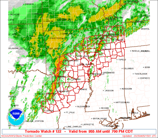
Tornado Watch Number 122
NWS Storm Prediction Center Norman OK
955 AM CDT Sat Apr 5 2025
The NWS Storm Prediction Center has issued a
* Tornado Watch for portions of
Southern and Eastern Arkansas
Northern Louisiana
Northern Mississippi
Western Tennessee
Northeast Texas
* Effective this Saturday morning and evening from 955 AM until
700 PM CDT.
* Primary threats include...
A few tornadoes likely with a couple intense tornadoes possible
Scattered damaging wind gusts to 70 mph likely
Scattered large hail and isolated very large hail events to 2
inches in diameter possible
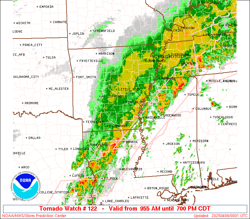
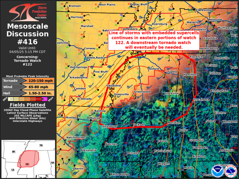
SUMMARY...Severe storms including supercells are expected to
increase through late morning into the afternoon, with tornadoes,
damaging winds, and hail all possible. See Mesoscale Discussion 409
for additional meteorological details.
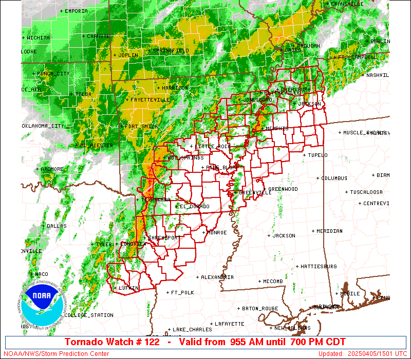
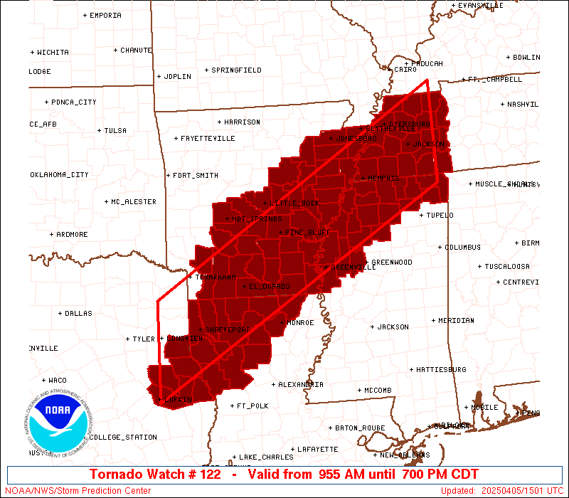
The tornado watch area is approximately along and 65 statute miles
north and south of a line from 20 miles south of Longview TX to 35
miles east northeast of Jackson TN. For a complete depiction of the
watch see the associated watch outline update (WOUS64 KWNS WOU2).
PRECAUTIONARY/PREPAREDNESS ACTIONS...
REMEMBER...A Tornado Watch means conditions are favorable for
tornadoes and severe thunderstorms in and close to the watch
area. Persons in these areas should be on the lookout for
threatening weather conditions and listen for later statements
and possible warnings.
&&
AVIATION...Tornadoes and a few severe thunderstorms with hail
surface and aloft to 2 inches. Extreme turbulence and surface wind
gusts to 60 knots. A few cumulonimbi with maximum tops to 550. Mean
storm motion vector 23035.
...Guyer
   SEL2

   URGENT - IMMEDIATE BROADCAST REQUESTED
   Tornado Watch Number 122
   NWS Storm Prediction Center Norman OK
   955 AM CDT Sat Apr 5 2025

   The NWS Storm Prediction Center has issued a

   * Tornado Watch for portions of
     Southern and Eastern Arkansas
     Northern Louisiana
     Northern Mississippi
     Western Tennessee
     Northeast Texas

   * Effective this Saturday morning and evening from 955 AM until
     700 PM CDT.

   * Primary threats include...
     A few tornadoes likely with a couple intense tornadoes possible
     Scattered damaging wind gusts to 70 mph likely
     Scattered large hail and isolated very large hail events to 2
       inches in diameter possible

   SUMMARY...Severe storms including supercells are expected to
   increase through late morning into the afternoon, with tornadoes,
   damaging winds, and hail all possible. See Mesoscale Discussion 409
   for additional meteorological details.

   The tornado watch area is approximately along and 65 statute miles
   north and south of a line from 20 miles south of Longview TX to 35
   miles east northeast of Jackson TN. For a complete depiction of the
   watch see the associated watch outline update (WOUS64 KWNS WOU2).

   PRECAUTIONARY/PREPAREDNESS ACTIONS...

   REMEMBER...A Tornado Watch means conditions are favorable for
   tornadoes and severe thunderstorms in and close to the watch
   area. Persons in these areas should be on the lookout for
   threatening weather conditions and listen for later statements
   and possible warnings.

   &&

   AVIATION...Tornadoes and a few severe thunderstorms with hail
   surface and aloft to 2 inches. Extreme turbulence and surface wind
   gusts to 60 knots. A few cumulonimbi with maximum tops to 550. Mean
   storm motion vector 23035.

   ...Guyer
 Note:
The Aviation Watch (SAW) product is an approximation to the watch area.
The actual watch is depicted by the shaded areas.
Note:
The Aviation Watch (SAW) product is an approximation to the watch area.
The actual watch is depicted by the shaded areas.
   SAW2
   WW 122 TORNADO AR LA MS TN TX 051455Z - 060000Z
   AXIS..65 STATUTE MILES NORTH AND SOUTH OF LINE..
   20S GGG/LONGVIEW TX/ - 35ENE MKL/JACKSON TN/
   ..AVIATION COORDS.. 55NM N/S /20S GGG - 49ESE DYR/
   HAIL SURFACE AND ALOFT..2 INCHES. WIND GUSTS..60 KNOTS.
   MAX TOPS TO 550. MEAN STORM MOTION VECTOR 23035.

   LAT...LON 33039472 36738834 34848834 31159472

   THIS IS AN APPROXIMATION TO THE WATCH AREA.  FOR A
   COMPLETE DEPICTION OF THE WATCH SEE WOUS64 KWNS
   FOR WOU2.
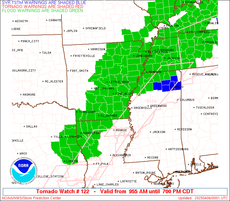
Watch 122 Status Report Messages:
STATUS REPORT #4 ON WW 122

VALID 052230Z - 052340Z

SEVERE WEATHER THREAT CONTINUES RIGHT OF A LINE FROM 20 NNW LFK
TO 40 E SHV TO 15 SE LLQ TO 15 ESE MEM TO 45 SSW CKV.

..DEAN..04/05/25

ATTN...WFO...LZK...JAN...SHV...MEG...

&&

STATUS REPORT FOR WT 122

SEVERE WEATHER THREAT CONTINUES FOR THE FOLLOWING AREAS

LAC013-031-049-061-069-073-081-085-111-127-052340-

LA
.    LOUISIANA PARISHES INCLUDED ARE

BIENVILLE	     DE SOTO		 JACKSON
LINCOLN 	     NATCHITOCHES	 OUACHITA
RED RIVER	     SABINE		 UNION
WINN
$$


TXC005-403-405-052340-

TX
.    TEXAS COUNTIES INCLUDED ARE

ANGELINA	     SABINE		 SAN AUGUSTINE
$$


THE WATCH STATUS MESSAGE IS FOR GUIDANCE PURPOSES ONLY.  PLEASE
REFER TO WATCH COUNTY NOTIFICATION STATEMENTS FOR OFFICIAL
INFORMATION ON COUNTIES...INDEPENDENT CITIES AND MARINE ZONES
CLEARED FROM SEVERE THUNDERSTORM AND TORNADO WATCHES.
$$

STATUS REPORT #3 ON WW 122

VALID 052025Z - 052140Z

SEVERE WEATHER THREAT CONTINUES RIGHT OF A LINE FROM 25 NNW LFK
TO 10 SE SHV TO 25 SE ELD TO 25 ENE LLQ TO 55 SW MEM TO 30 WSW
MKL TO 10 N MKL TO 35 NNE MKL TO 40 SSW PAH.

..BENTLEY..04/05/25

ATTN...WFO...LZK...JAN...SHV...MEG...

&&

STATUS REPORT FOR WT 122

SEVERE WEATHER THREAT CONTINUES FOR THE FOLLOWING AREAS

ARC003-017-041-043-107-052140-

AR
.    ARKANSAS COUNTIES INCLUDED ARE

ASHLEY		     CHICOT		 DESHA
DREW		     PHILLIPS
$$


LAC013-027-031-049-061-067-069-073-081-085-111-127-052140-

LA
.    LOUISIANA PARISHES INCLUDED ARE

BIENVILLE	     CLAIBORNE		 DE SOTO
JACKSON 	     LINCOLN		 MOREHOUSE
NATCHITOCHES	     OUACHITA		 RED RIVER
SABINE		     UNION		 WINN
$$


MSC003-009-011-027-033-071-083-093-107-117-119-133-135-137-139-
141-143-145-151-161-052140-

MS
.    MISSISSIPPI COUNTIES INCLUDED ARE

ALCORN		     BENTON		 BOLIVAR
COAHOMA 	     DESOTO		 LAFAYETTE
LEFLORE 	     MARSHALL		 PANOLA
PRENTISS	     QUITMAN		 SUNFLOWER
TALLAHATCHIE	     TATE		 TIPPAH
TISHOMINGO	     TUNICA		 UNION
WASHINGTON	     YALOBUSHA
$$


TNC005-017-023-033-039-047-069-071-075-077-079-109-113-131-157-
183-052140-

TN
.    TENNESSEE COUNTIES INCLUDED ARE

BENTON		     CARROLL		 CHESTER
CROCKETT	     DECATUR		 FAYETTE
HARDEMAN	     HARDIN		 HAYWOOD
HENDERSON	     HENRY		 MCNAIRY
MADISON 	     OBION		 SHELBY
WEAKLEY
$$


TXC005-347-403-405-419-052140-

TX
.    TEXAS COUNTIES INCLUDED ARE

ANGELINA	     NACOGDOCHES	 SABINE
SAN AUGUSTINE	     SHELBY
$$


THE WATCH STATUS MESSAGE IS FOR GUIDANCE PURPOSES ONLY.  PLEASE
REFER TO WATCH COUNTY NOTIFICATION STATEMENTS FOR OFFICIAL
INFORMATION ON COUNTIES...INDEPENDENT CITIES AND MARINE ZONES
CLEARED FROM SEVERE THUNDERSTORM AND TORNADO WATCHES.
$$

STATUS REPORT #2 ON WW 122

VALID 051830Z - 051940Z

SEVERE WEATHER THREAT CONTINUES RIGHT OF A LINE FROM 35 SSW GGG
TO 30 NE SHV TO 30 NE ELD TO 10 E PBF TO 55 W MEM TO 15 SSW JBR
TO 5 NE ARG.

..BENTLEY..04/05/25

ATTN...WFO...LZK...JAN...SHV...MEG...

&&

STATUS REPORT FOR WT 122

SEVERE WEATHER THREAT CONTINUES FOR THE FOLLOWING AREAS

ARC001-003-011-017-025-031-035-037-041-043-069-077-079-093-095-
107-111-123-139-051940-

AR
.    ARKANSAS COUNTIES INCLUDED ARE

ARKANSAS	     ASHLEY		 BRADLEY
CHICOT		     CLEVELAND		 CRAIGHEAD
CRITTENDEN	     CROSS		 DESHA
DREW		     JEFFERSON		 LEE
LINCOLN 	     MISSISSIPPI	 MONROE
PHILLIPS	     POINSETT		 ST. FRANCIS
UNION
$$


LAC013-015-017-027-031-049-061-067-069-073-081-085-111-119-127-
051940-

LA
.    LOUISIANA PARISHES INCLUDED ARE

BIENVILLE	     BOSSIER		 CADDO
CLAIBORNE	     DE SOTO		 JACKSON
LINCOLN 	     MOREHOUSE		 NATCHITOCHES
OUACHITA	     RED RIVER		 SABINE
UNION		     WEBSTER		 WINN
$$


MSC003-009-011-027-033-071-083-093-107-117-119-133-135-137-139-
141-143-145-151-161-051940-

MS
.    MISSISSIPPI COUNTIES INCLUDED ARE

ALCORN		     BENTON		 BOLIVAR
COAHOMA 	     DESOTO		 LAFAYETTE
LEFLORE 	     MARSHALL		 PANOLA
PRENTISS	     QUITMAN		 SUNFLOWER
TALLAHATCHIE	     TATE		 TIPPAH
TISHOMINGO	     TUNICA		 UNION
WASHINGTON	     YALOBUSHA
$$


TNC005-017-023-033-039-045-047-053-069-071-075-077-079-097-109-
113-131-157-167-183-051940-

TN
.    TENNESSEE COUNTIES INCLUDED ARE

BENTON		     CARROLL		 CHESTER
CROCKETT	     DECATUR		 DYER
FAYETTE 	     GIBSON		 HARDEMAN
HARDIN		     HAYWOOD		 HENDERSON
HENRY		     LAUDERDALE 	 MCNAIRY
MADISON 	     OBION		 SHELBY
TIPTON		     WEAKLEY
$$


TXC005-347-365-403-405-419-051940-

TX
.    TEXAS COUNTIES INCLUDED ARE

ANGELINA	     NACOGDOCHES	 PANOLA
SABINE		     SAN AUGUSTINE	 SHELBY
$$


THE WATCH STATUS MESSAGE IS FOR GUIDANCE PURPOSES ONLY.  PLEASE
REFER TO WATCH COUNTY NOTIFICATION STATEMENTS FOR OFFICIAL
INFORMATION ON COUNTIES...INDEPENDENT CITIES AND MARINE ZONES
CLEARED FROM SEVERE THUNDERSTORM AND TORNADO WATCHES.
$$

STATUS REPORT #1 ON WW 122

VALID 051700Z - 051840Z

SEVERE WEATHER THREAT CONTINUES RIGHT OF A LINE FROM 25 SSW GGG
TO 20 N SHV TO 40 N ELD TO 5 SSW LIT.

FOR ADDITIONAL INFORMATION SEE MESOSCALE DISCUSSION 411

..BENTLEY..04/05/25

ATTN...WFO...LZK...JAN...SHV...MEG...

&&

STATUS REPORT FOR WT 122

SEVERE WEATHER THREAT CONTINUES FOR THE FOLLOWING AREAS

ARC001-003-011-013-017-025-027-031-035-037-039-041-043-053-067-
069-073-077-079-085-093-095-103-107-111-117-123-139-145-147-
051840-

AR
.    ARKANSAS COUNTIES INCLUDED ARE

ARKANSAS	     ASHLEY		 BRADLEY
CALHOUN 	     CHICOT		 CLEVELAND
COLUMBIA	     CRAIGHEAD		 CRITTENDEN
CROSS		     DALLAS		 DESHA
DREW		     GRANT		 JACKSON
JEFFERSON	     LAFAYETTE		 LEE
LINCOLN 	     LONOKE		 MISSISSIPPI
MONROE		     OUACHITA		 PHILLIPS
POINSETT	     PRAIRIE		 ST. FRANCIS
UNION		     WHITE		 WOODRUFF
$$


LAC013-015-017-027-031-049-061-067-069-073-081-085-111-119-127-
051840-

LA
.    LOUISIANA PARISHES INCLUDED ARE

BIENVILLE	     BOSSIER		 CADDO
CLAIBORNE	     DE SOTO		 JACKSON
LINCOLN 	     MOREHOUSE		 NATCHITOCHES
OUACHITA	     RED RIVER		 SABINE
UNION		     WEBSTER		 WINN
$$


MSC003-009-011-027-033-071-083-093-107-117-119-133-135-137-139-
141-143-145-151-161-051840-

MS
.    MISSISSIPPI COUNTIES INCLUDED ARE

ALCORN		     BENTON		 BOLIVAR
COAHOMA 	     DESOTO		 LAFAYETTE
LEFLORE 	     MARSHALL		 PANOLA
PRENTISS	     QUITMAN		 SUNFLOWER
TALLAHATCHIE	     TATE		 TIPPAH
TISHOMINGO	     TUNICA		 UNION
WASHINGTON	     YALOBUSHA
$$


TNC005-017-023-033-039-045-047-053-069-071-075-077-079-097-109-
113-131-157-167-183-051840-

TN
.    TENNESSEE COUNTIES INCLUDED ARE

BENTON		     CARROLL		 CHESTER
CROCKETT	     DECATUR		 DYER
FAYETTE 	     GIBSON		 HARDEMAN
HARDIN		     HAYWOOD		 HENDERSON
HENRY		     LAUDERDALE 	 MCNAIRY
MADISON 	     OBION		 SHELBY
TIPTON		     WEAKLEY
$$


TXC005-347-365-403-405-419-051840-

TX
.    TEXAS COUNTIES INCLUDED ARE

ANGELINA	     NACOGDOCHES	 PANOLA
SABINE		     SAN AUGUSTINE	 SHELBY
$$


THE WATCH STATUS MESSAGE IS FOR GUIDANCE PURPOSES ONLY.  PLEASE
REFER TO WATCH COUNTY NOTIFICATION STATEMENTS FOR OFFICIAL
INFORMATION ON COUNTIES...INDEPENDENT CITIES AND MARINE ZONES
CLEARED FROM SEVERE THUNDERSTORM AND TORNADO WATCHES.
$$
Note:
Click for Complete Product Text.
Tornadoes
Probability of 2 or more tornadoes
|
High (70%)
|
Probability of 1 or more strong (EF2-EF5) tornadoes
|
Mod (50%)
|
Wind
Probability of 10 or more severe wind events
|
Mod (60%)
|
Probability of 1 or more wind events > 65 knots
|
Low (20%)
|
Hail
Probability of 10 or more severe hail events
|
Mod (40%)
|
Probability of 1 or more hailstones > 2 inches
|
Mod (30%)
|
Combined Severe Hail/Wind
Probability of 6 or more combined severe hail/wind events
|
High (>95%)
|
For each watch, probabilities for particular events inside the watch
(listed above in each table) are determined by the issuing forecaster.
The "Low" category contains probability values ranging from less than 2%
to 20% (EF2-EF5 tornadoes), less than 5% to 20% (all other probabilities),
"Moderate" from 30% to 60%, and "High" from 70% to greater than 95%.
High values are bolded and lighter in color to provide awareness of
an increased threat for a particular event.


 @NWSSPC