|
| Mesoscale Discussion 411 |
|
< Previous MD Next MD >
|
|
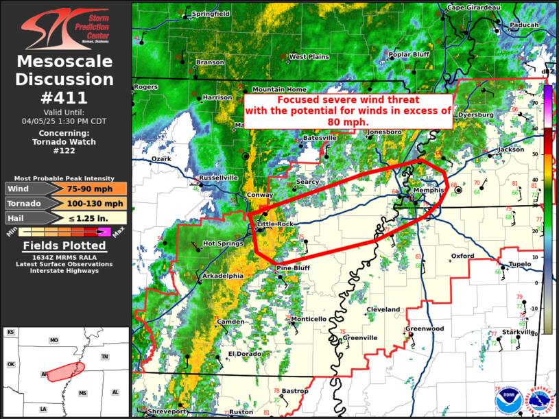
   Mesoscale Discussion 0411
   NWS Storm Prediction Center Norman OK
   1136 AM CDT Sat Apr 05 2025

   Areas affected...central Arkansas to southwest Tennessee and far
   northwest Mississippi

   Concerning...Tornado Watch 122...

   Valid 051636Z - 051830Z

   The severe weather threat for Tornado Watch 122 continues.

   SUMMARY...A focused severe wind threat is developing across central
   Arkansas toward western Tennessee with the potential for winds in
   excess of 80 mph.

   DISCUSSION...A bowing line segment has developed along the frontal
   zone/composite outflow in central Arkansas with a recent measured
   wind gust of 58 knots at KORK at 1615 UTC. In addition, a well
   organized rear-inflow jet is being sampled by the KLZK WSR-88D. The
   airmass south of this boundary continues to destabilize with further
   destabilization to 2000-2500 J/kg MLCAPE expected by early
   afternoon. Expect this bow to traverse along this frontal/outflow
   zone through the afternoon. In addition to current
   radar/observational trends which support this corridor of a higher
   wind threat, the 15Z WoFS also highlights this corridor early this
   afternoon with 90th percentile wind gusts around 65 knots across
   southwest Tennessee.

   In addition to the severe wind threat (which will exist on both
   sides of the boundary), a tornado threat will also exist south of
   this boundary, although line orientation may not be as favorable
   based on current WSR-88D depiction from KLZK. The greatest tornado
   threat will likely exist along the boundary where low-level
   vorticity will be enhanced.

   ..Bentley.. 04/05/2025

   ...Please see www.spc.noaa.gov for graphic product...

   ATTN...WFO...MEG...LZK...

   LAT...LON   34329196 34479226 34759231 34909237 35399073 35558990
               35408958 35238953 35058963 34888987 34619058 34329196

   MOST PROBABLE PEAK TORNADO INTENSITY...100-130 MPH
   MOST PROBABLE PEAK WIND GUST...75-90 MPH
   MOST PROBABLE PEAK HAIL SIZE...UP TO 1.25 IN
|
|
Top/All Mesoscale Discussions/Forecast Products/Home
|
|


 @NWSSPC