 Note:
The expiration time in the watch graphic is amended if the watch is
replaced, cancelled or extended.
Note:
Note:
The expiration time in the watch graphic is amended if the watch is
replaced, cancelled or extended.
Note: Click for
Watch Status Reports.
SEL9
URGENT - IMMEDIATE BROADCAST REQUESTED
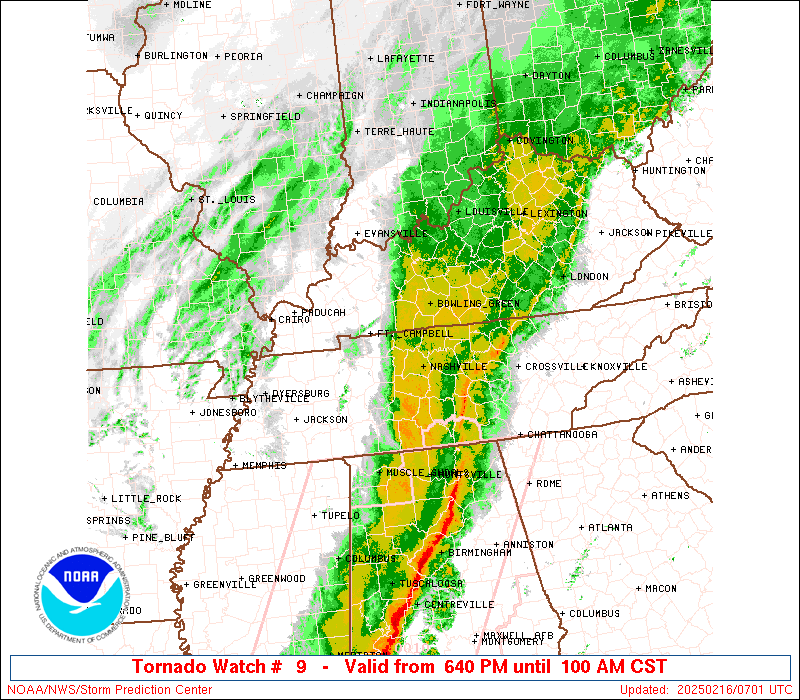
Tornado Watch Number 9
NWS Storm Prediction Center Norman OK
640 PM CST Sat Feb 15 2025
The NWS Storm Prediction Center has issued a
* Tornado Watch for portions of
South Central Kentucky
Middle Tennessee
* Effective this Saturday night and Sunday morning from 640 PM
until 100 AM CST.
* Primary threats include...
A few tornadoes possible
Scattered damaging wind gusts to 70 mph possible
SUMMARY...Fast-moving thunderstorms over west Tennessee will track
into the watch area this evening, posing a risk of locally damaging
wind gusts and a few tornadoes.
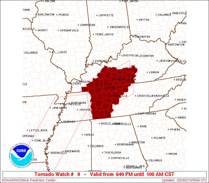
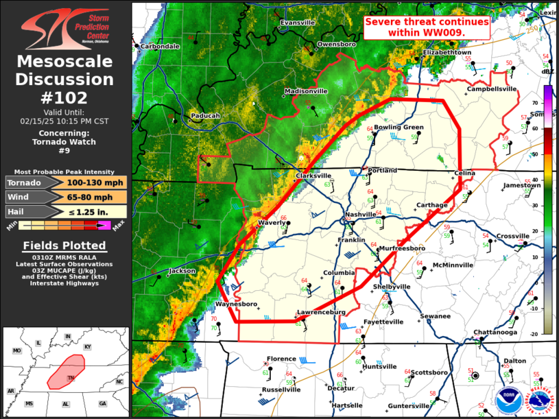
The tornado watch area is approximately along and 60 statute miles
north and south of a line from 60 miles southwest of Clarksville TN
to 70 miles east of Bowling Green KY. For a complete depiction of
the watch see the associated watch outline update (WOUS64 KWNS
WOU9).
PRECAUTIONARY/PREPAREDNESS ACTIONS...
REMEMBER...A Tornado Watch means conditions are favorable for
tornadoes and severe thunderstorms in and close to the watch
area. Persons in these areas should be on the lookout for
threatening weather conditions and listen for later statements
and possible warnings.
&&
OTHER WATCH INFORMATION...CONTINUE...WW 8...
AVIATION...Tornadoes and a few severe thunderstorms with hail
surface and aloft to 1.5 inches. Extreme turbulence and surface wind
gusts to 60 knots. A few cumulonimbi with maximum tops to 450. Mean
storm motion vector 24035.
...Hart

   SEL9

   URGENT - IMMEDIATE BROADCAST REQUESTED
   Tornado Watch Number 9
   NWS Storm Prediction Center Norman OK
   640 PM CST Sat Feb 15 2025

   The NWS Storm Prediction Center has issued a

   * Tornado Watch for portions of
     South Central Kentucky
     Middle Tennessee

   * Effective this Saturday night and Sunday morning from 640 PM
     until 100 AM CST.

   * Primary threats include...
     A few tornadoes possible
     Scattered damaging wind gusts to 70 mph possible

   SUMMARY...Fast-moving thunderstorms over west Tennessee will track
   into the watch area this evening, posing a risk of locally damaging
   wind gusts and a few tornadoes.

   The tornado watch area is approximately along and 60 statute miles
   north and south of a line from 60 miles southwest of Clarksville TN
   to 70 miles east of Bowling Green KY. For a complete depiction of
   the watch see the associated watch outline update (WOUS64 KWNS
   WOU9).

   PRECAUTIONARY/PREPAREDNESS ACTIONS...

   REMEMBER...A Tornado Watch means conditions are favorable for
   tornadoes and severe thunderstorms in and close to the watch
   area. Persons in these areas should be on the lookout for
   threatening weather conditions and listen for later statements
   and possible warnings.

   &&

   OTHER WATCH INFORMATION...CONTINUE...WW 8...

   AVIATION...Tornadoes and a few severe thunderstorms with hail
   surface and aloft to 1.5 inches. Extreme turbulence and surface wind
   gusts to 60 knots. A few cumulonimbi with maximum tops to 450. Mean
   storm motion vector 24035.

   ...Hart
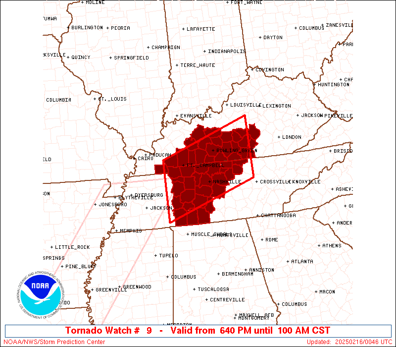
 Note:
The Aviation Watch (SAW) product is an approximation to the watch area.
The actual watch is depicted by the shaded areas.
Note:
The Aviation Watch (SAW) product is an approximation to the watch area.
The actual watch is depicted by the shaded areas.
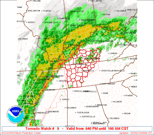
   SAW9
   WW 9 TORNADO KY TN 160040Z - 160700Z
   AXIS..60 STATUTE MILES NORTH AND SOUTH OF LINE..
   60SW CKV/CLARKSVILLE TN/ - 70E BWG/BOWLING GREEN KY/
   ..AVIATION COORDS.. 50NM N/S /55E DYR - 50W LOZ/
   HAIL SURFACE AND ALOFT..1.5 INCHES. WIND GUSTS..60 KNOTS.
   MAX TOPS TO 450. MEAN STORM MOTION VECTOR 24035.

   LAT...LON 36868818 37838515 36098515 35138818

   THIS IS AN APPROXIMATION TO THE WATCH AREA.  FOR A
   COMPLETE DEPICTION OF THE WATCH SEE WOUS64 KWNS
   FOR WOU9.
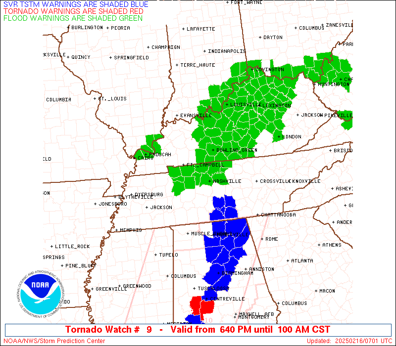
Watch 9 Status Report Messages:
STATUS REPORT #5 ON WW 9

VALID 160530Z - 160640Z

SEVERE WEATHER THREAT CONTINUES RIGHT OF A LINE FROM 15 WNW MSL
TO 45 SSW BNA TO 10 NE BNA TO 35 E BWG TO 50 SSW LEX.

..THORNTON..02/16/25

ATTN...WFO...LMK...PAH...OHX...

&&

STATUS REPORT FOR WT 9

SEVERE WEATHER THREAT CONTINUES FOR THE FOLLOWING AREAS

KYC001-045-053-057-169-171-207-160640-

KY
.    KENTUCKY COUNTIES INCLUDED ARE

ADAIR		     CASEY		 CLINTON
CUMBERLAND	     METCALFE		 MONROE
RUSSELL
$$


TNC003-027-055-087-111-117-149-159-165-169-189-160640-

TN
.    TENNESSEE COUNTIES INCLUDED ARE

BEDFORD 	     CLAY		 GILES
JACKSON 	     MACON		 MARSHALL
RUTHERFORD	     SMITH		 SUMNER
TROUSDALE	     WILSON
$$


THE WATCH STATUS MESSAGE IS FOR GUIDANCE PURPOSES ONLY.  PLEASE
REFER TO WATCH COUNTY NOTIFICATION STATEMENTS FOR OFFICIAL
INFORMATION ON COUNTIES...INDEPENDENT CITIES AND MARINE ZONES
CLEARED FROM SEVERE THUNDERSTORM AND TORNADO WATCHES.
$$

STATUS REPORT #4 ON WW 9

VALID 160425Z - 160540Z

SEVERE WEATHER THREAT CONTINUES RIGHT OF A LINE FROM 45 SE MKL TO
15 WNW BNA TO 15 S BWG TO 30 NE BWG TO 25 S SDF.

..THORNTON..02/16/25

ATTN...WFO...LMK...PAH...OHX...

&&

STATUS REPORT FOR WT 9

SEVERE WEATHER THREAT CONTINUES FOR THE FOLLOWING AREAS

KYC001-003-009-045-053-057-087-169-171-207-217-227-160540-

KY
.    KENTUCKY COUNTIES INCLUDED ARE

ADAIR		     ALLEN		 BARREN
CASEY		     CLINTON		 CUMBERLAND
GREEN		     METCALFE		 MONROE
RUSSELL 	     TAYLOR		 WARREN
$$


TNC003-027-037-055-081-087-099-101-111-117-119-149-159-165-169-
181-187-189-160540-

TN
.    TENNESSEE COUNTIES INCLUDED ARE

BEDFORD 	     CLAY		 DAVIDSON
GILES		     HICKMAN		 JACKSON
LAWRENCE	     LEWIS		 MACON
MARSHALL	     MAURY		 RUTHERFORD
SMITH		     SUMNER		 TROUSDALE
WAYNE		     WILLIAMSON 	 WILSON
$$


THE WATCH STATUS MESSAGE IS FOR GUIDANCE PURPOSES ONLY.  PLEASE
REFER TO WATCH COUNTY NOTIFICATION STATEMENTS FOR OFFICIAL
INFORMATION ON COUNTIES...INDEPENDENT CITIES AND MARINE ZONES
CLEARED FROM SEVERE THUNDERSTORM AND TORNADO WATCHES.
$$

STATUS REPORT #3 ON WW 9

VALID 160325Z - 160440Z

SEVERE WEATHER THREAT CONTINUES RIGHT OF A LINE FROM 35 ENE MKL
TO 40 SSW CKV TO 10 SE CKV TO 25 ENE CKV TO 25 NNW BWG TO 45 SSW
SDF TO 40 SSW SDF.

FOR ADDITIONAL INFORMATION SEE MESOSCALE DISCUSSION 102

..THORNTON..02/16/25

ATTN...WFO...LMK...PAH...OHX...

&&

STATUS REPORT FOR WT 9

SEVERE WEATHER THREAT CONTINUES FOR THE FOLLOWING AREAS

KYC001-003-009-045-053-057-061-087-099-141-169-171-207-213-217-
227-160440-

KY
.    KENTUCKY COUNTIES INCLUDED ARE

ADAIR		     ALLEN		 BARREN
CASEY		     CLINTON		 CUMBERLAND
EDMONSON	     GREEN		 HART
LOGAN		     METCALFE		 MONROE
RUSSELL 	     SIMPSON		 TAYLOR
WARREN
$$


TNC003-021-027-037-043-055-081-085-087-099-101-111-117-119-125-
135-147-149-159-165-169-181-187-189-160440-

TN
.    TENNESSEE COUNTIES INCLUDED ARE

BEDFORD 	     CHEATHAM		 CLAY
DAVIDSON	     DICKSON		 GILES
HICKMAN 	     HUMPHREYS		 JACKSON
LAWRENCE	     LEWIS		 MACON
MARSHALL	     MAURY		 MONTGOMERY
PERRY		     ROBERTSON		 RUTHERFORD
SMITH		     SUMNER		 TROUSDALE
WAYNE		     WILLIAMSON 	 WILSON
$$


THE WATCH STATUS MESSAGE IS FOR GUIDANCE PURPOSES ONLY.  PLEASE
REFER TO WATCH COUNTY NOTIFICATION STATEMENTS FOR OFFICIAL
INFORMATION ON COUNTIES...INDEPENDENT CITIES AND MARINE ZONES
CLEARED FROM SEVERE THUNDERSTORM AND TORNADO WATCHES.
$$

STATUS REPORT #2 ON WW 9

VALID 160235Z - 160340Z

SEVERE WEATHER THREAT CONTINUES RIGHT OF A LINE FROM 50 WSW HOP
TO 10 WSW HOP TO 25 N HOP TO 45 N BWG.

..THORNTON..02/16/25

ATTN...WFO...LMK...PAH...OHX...

&&

STATUS REPORT FOR WT 9

SEVERE WEATHER THREAT CONTINUES FOR THE FOLLOWING AREAS

KYC001-003-009-031-045-047-053-057-061-085-087-099-141-169-171-
207-213-217-219-227-160340-

KY
.    KENTUCKY COUNTIES INCLUDED ARE

ADAIR		     ALLEN		 BARREN
BUTLER		     CASEY		 CHRISTIAN
CLINTON 	     CUMBERLAND 	 EDMONSON
GRAYSON 	     GREEN		 HART
LOGAN		     METCALFE		 MONROE
RUSSELL 	     SIMPSON		 TAYLOR
TODD		     WARREN
$$


TNC021-027-037-043-055-081-083-085-087-099-101-111-117-119-125-
135-147-149-159-161-165-169-181-187-189-160340-

TN
.    TENNESSEE COUNTIES INCLUDED ARE

CHEATHAM	     CLAY		 DAVIDSON
DICKSON 	     GILES		 HICKMAN
HOUSTON 	     HUMPHREYS		 JACKSON
LAWRENCE	     LEWIS		 MACON
MARSHALL	     MAURY		 MONTGOMERY
PERRY		     ROBERTSON		 RUTHERFORD
SMITH		     STEWART		 SUMNER
TROUSDALE	     WAYNE		 WILLIAMSON
WILSON
$$


THE WATCH STATUS MESSAGE IS FOR GUIDANCE PURPOSES ONLY.  PLEASE
REFER TO WATCH COUNTY NOTIFICATION STATEMENTS FOR OFFICIAL
INFORMATION ON COUNTIES...INDEPENDENT CITIES AND MARINE ZONES
CLEARED FROM SEVERE THUNDERSTORM AND TORNADO WATCHES.
$$

STATUS REPORT #1 ON WW 9

VALID 160130Z - 160240Z

THE SEVERE WEATHER THREAT CONTINUES ACROSS THE ENTIRE WATCH AREA.

..THORNTON..02/16/25

ATTN...WFO...LMK...PAH...OHX...

&&

STATUS REPORT FOR WT 9

SEVERE WEATHER THREAT CONTINUES FOR THE FOLLOWING AREAS

KYC001-003-009-031-035-045-047-053-057-061-085-087-099-141-169-
171-177-183-207-213-217-219-221-227-160240-

KY
.    KENTUCKY COUNTIES INCLUDED ARE

ADAIR		     ALLEN		 BARREN
BUTLER		     CALLOWAY		 CASEY
CHRISTIAN	     CLINTON		 CUMBERLAND
EDMONSON	     GRAYSON		 GREEN
HART		     LOGAN		 METCALFE
MONROE		     MUHLENBERG 	 OHIO
RUSSELL 	     SIMPSON		 TAYLOR
TODD		     TRIGG		 WARREN
$$


TNC021-027-037-043-055-081-083-085-087-099-101-111-117-119-125-
135-147-149-159-161-165-169-181-187-189-160240-

TN
.    TENNESSEE COUNTIES INCLUDED ARE

CHEATHAM	     CLAY		 DAVIDSON
DICKSON 	     GILES		 HICKMAN
HOUSTON 	     HUMPHREYS		 JACKSON
LAWRENCE	     LEWIS		 MACON
MARSHALL	     MAURY		 MONTGOMERY
PERRY		     ROBERTSON		 RUTHERFORD
SMITH		     STEWART		 SUMNER
TROUSDALE	     WAYNE		 WILLIAMSON
WILSON
$$


THE WATCH STATUS MESSAGE IS FOR GUIDANCE PURPOSES ONLY.  PLEASE
REFER TO WATCH COUNTY NOTIFICATION STATEMENTS FOR OFFICIAL
INFORMATION ON COUNTIES...INDEPENDENT CITIES AND MARINE ZONES
CLEARED FROM SEVERE THUNDERSTORM AND TORNADO WATCHES.
$$
Note:
Click for Complete Product Text.
Tornadoes
Probability of 2 or more tornadoes
|
Mod (50%)
|
Probability of 1 or more strong (EF2-EF5) tornadoes
|
Low (20%)
|
Wind
Probability of 10 or more severe wind events
|
Mod (50%)
|
Probability of 1 or more wind events > 65 knots
|
Low (20%)
|
Hail
Probability of 10 or more severe hail events
|
Low (10%)
|
Probability of 1 or more hailstones > 2 inches
|
Low (<5%)
|
Combined Severe Hail/Wind
Probability of 6 or more combined severe hail/wind events
|
Mod (60%)
|
For each watch, probabilities for particular events inside the watch
(listed above in each table) are determined by the issuing forecaster.
The "Low" category contains probability values ranging from less than 2%
to 20% (EF2-EF5 tornadoes), less than 5% to 20% (all other probabilities),
"Moderate" from 30% to 60%, and "High" from 70% to greater than 95%.
High values are bolded and lighter in color to provide awareness of
an increased threat for a particular event.


 @NWSSPC