 Note:
The expiration time in the watch graphic is amended if the watch is
replaced, cancelled or extended.
Note:
Note:
The expiration time in the watch graphic is amended if the watch is
replaced, cancelled or extended.
Note: Click for
Watch Status Reports.
SEL2
URGENT - IMMEDIATE BROADCAST REQUESTED
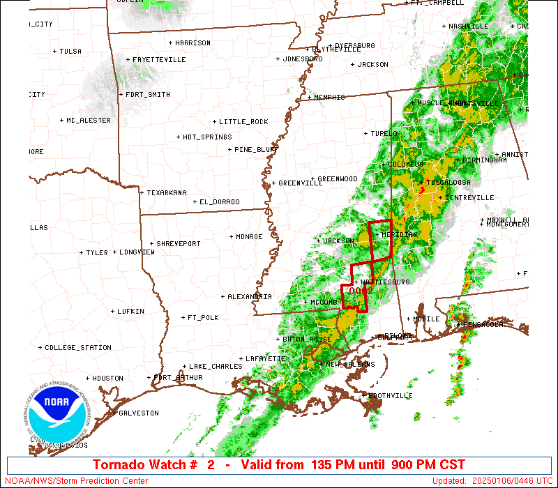
Tornado Watch Number 2
NWS Storm Prediction Center Norman OK
135 PM CST Sun Jan 5 2025
The NWS Storm Prediction Center has issued a
* Tornado Watch for portions of
Far Eastern Arkansas
Eastern and Southeast Louisiana
Southwest into Central and Northern Mississippi
* Effective this Sunday afternoon and evening from 135 PM until
900 PM CST.
* Primary threats include...
A few tornadoes likely with a couple intense tornadoes possible
Scattered damaging winds likely with isolated significant gusts
to 75 mph possible
Isolated large hail events to 1.5 inches in diameter possible
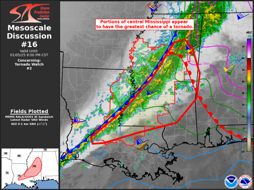
SUMMARY...Isolated to scattered thunderstorms will likely continue
to develop ahead a squall line this afternoon and evening. The more
intense storms will likely be supercellular and pose a risk for
tornadoes, a couple of which may be strong. Scattered damaging
gusts and a risk for a tornado will also accompany the squall line
as it pushes east across the Watch area this afternoon through the
evening.
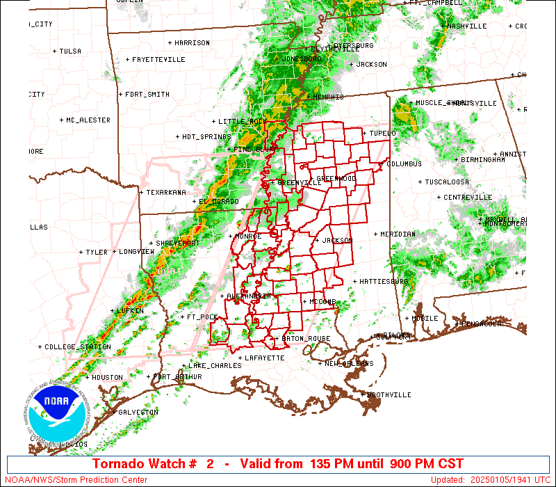
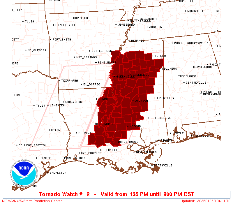
The tornado watch area is approximately along and 75 statute miles
east and west of a line from 5 miles east northeast of Oxford MS to
75 miles south southeast of Alexandria LA. For a complete depiction
of the watch see the associated watch outline update (WOUS64 KWNS
WOU2).
PRECAUTIONARY/PREPAREDNESS ACTIONS...
REMEMBER...A Tornado Watch means conditions are favorable for
tornadoes and severe thunderstorms in and close to the watch
area. Persons in these areas should be on the lookout for
threatening weather conditions and listen for later statements
and possible warnings.
&&
OTHER WATCH INFORMATION...CONTINUE...WW 1...
AVIATION...Tornadoes and a few severe thunderstorms with hail
surface and aloft to 1.5 inches. Extreme turbulence and surface wind
gusts to 65 knots. A few cumulonimbi with maximum tops to 450. Mean
storm motion vector 24040.
...Smith

   SEL2

   URGENT - IMMEDIATE BROADCAST REQUESTED
   Tornado Watch Number 2
   NWS Storm Prediction Center Norman OK
   135 PM CST Sun Jan 5 2025

   The NWS Storm Prediction Center has issued a

   * Tornado Watch for portions of
     Far Eastern Arkansas
     Eastern and Southeast Louisiana
     Southwest into Central and Northern Mississippi

   * Effective this Sunday afternoon and evening from 135 PM until
     900 PM CST.

   * Primary threats include...
     A few tornadoes likely with a couple intense tornadoes possible
     Scattered damaging winds likely with isolated significant gusts
       to 75 mph possible
     Isolated large hail events to 1.5 inches in diameter possible

   SUMMARY...Isolated to scattered thunderstorms will likely continue
   to develop ahead a squall line this afternoon and evening.  The more
   intense storms will likely be supercellular and pose a risk for
   tornadoes, a couple of which may be strong.  Scattered damaging
   gusts and a risk for a tornado will also accompany the squall line
   as it pushes east across the Watch area this afternoon through the
   evening.

   The tornado watch area is approximately along and 75 statute miles
   east and west of a line from 5 miles east northeast of Oxford MS to
   75 miles south southeast of Alexandria LA. For a complete depiction
   of the watch see the associated watch outline update (WOUS64 KWNS
   WOU2).

   PRECAUTIONARY/PREPAREDNESS ACTIONS...

   REMEMBER...A Tornado Watch means conditions are favorable for
   tornadoes and severe thunderstorms in and close to the watch
   area. Persons in these areas should be on the lookout for
   threatening weather conditions and listen for later statements
   and possible warnings.

   &&

   OTHER WATCH INFORMATION...CONTINUE...WW 1...

   AVIATION...Tornadoes and a few severe thunderstorms with hail
   surface and aloft to 1.5 inches. Extreme turbulence and surface wind
   gusts to 65 knots. A few cumulonimbi with maximum tops to 450. Mean
   storm motion vector 24040.

   ...Smith
 Note:
The Aviation Watch (SAW) product is an approximation to the watch area.
The actual watch is depicted by the shaded areas.
Note:
The Aviation Watch (SAW) product is an approximation to the watch area.
The actual watch is depicted by the shaded areas.
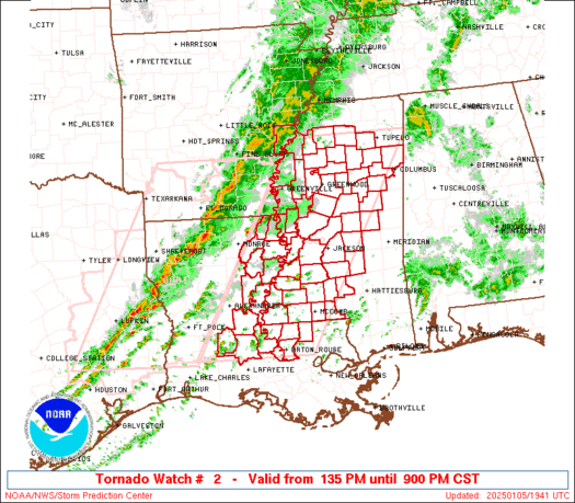
   SAW2
   WW 2 TORNADO AR LA MS 051935Z - 060300Z
   AXIS..75 STATUTE MILES EAST AND WEST OF LINE..
   5ENE UOX/OXFORD MS/ - 75SSE ESF/ALEXANDRIA LA/
   ..AVIATION COORDS.. 65NM E/W /47SE MEM - 27W BTR/
   HAIL SURFACE AND ALOFT..1.5 INCHES. WIND GUSTS..65 KNOTS.
   MAX TOPS TO 450. MEAN STORM MOTION VECTOR 24040.

   LAT...LON 34408813 30399056 30399308 34409076

   THIS IS AN APPROXIMATION TO THE WATCH AREA.  FOR A
   COMPLETE DEPICTION OF THE WATCH SEE WOUS64 KWNS
   FOR WOU2.
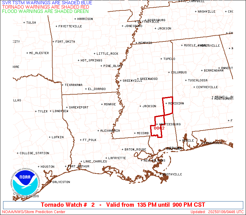
Watch 2 Status Report Messages:
STATUS REPORT #3 ON WW 2

VALID 060110Z - 060240Z

SEVERE WEATHER THREAT CONTINUES RIGHT OF A LINE FROM 20 WNW LFT
TO 50 NNE LFT TO 20 SE HEZ TO 50 ENE HEZ TO 55 S GWO TO 20 WNW
CBM TO 15 SE TUP TO 30 NE TUP.

..JEWELL..01/06/25

ATTN...WFO...MEG...LCH...JAN...LIX...

&&

STATUS REPORT FOR WT 2

SEVERE WEATHER THREAT CONTINUES FOR THE FOLLOWING AREAS

LAC033-037-077-091-097-121-125-060240-

LA
.    LOUISIANA PARISHES INCLUDED ARE

EAST BATON ROUGE     EAST FELICIANA	 POINTE COUPEE
ST. HELENA	     ST. LANDRY 	 WEST BATON ROUGE
WEST FELICIANA
$$


MSC005-007-019-023-025-029-037-049-061-063-065-069-075-077-079-
085-087-089-099-101-103-105-113-121-123-127-129-147-157-159-
060240-

MS
.    MISSISSIPPI COUNTIES INCLUDED ARE

AMITE		     ATTALA		 CHOCTAW
CLARKE		     CLAY		 COPIAH
FRANKLIN	     HINDS		 JASPER
JEFFERSON	     JEFFERSON DAVIS	 KEMPER
LAUDERDALE	     LAWRENCE		 LEAKE
LINCOLN 	     LOWNDES		 MADISON
NESHOBA 	     NEWTON		 NOXUBEE
OKTIBBEHA	     PIKE		 RANKIN
SCOTT		     SIMPSON		 SMITH
WALTHALL	     WILKINSON		 WINSTON
$$


THE WATCH STATUS MESSAGE IS FOR GUIDANCE PURPOSES ONLY.  PLEASE
REFER TO WATCH COUNTY NOTIFICATION STATEMENTS FOR OFFICIAL
INFORMATION ON COUNTIES...INDEPENDENT CITIES AND MARINE ZONES
CLEARED FROM SEVERE THUNDERSTORM AND TORNADO WATCHES.
$$

STATUS REPORT #2 ON WW 2

VALID 052230Z - 052340Z

SEVERE WEATHER THREAT CONTINUES RIGHT OF A LINE FROM 25 SSW MLU
TO 20 E MLU TO 45 ENE MLU TO 30 S GLH TO 15 SSE GLH TO 30 NE GLH
TO 35 SW MEM.

..JEWELL..01/05/25

ATTN...WFO...MEG...LCH...JAN...LIX...

&&

STATUS REPORT FOR WT 2

SEVERE WEATHER THREAT CONTINUES FOR THE FOLLOWING AREAS

LAC009-025-029-033-035-037-039-041-065-077-083-091-097-107-121-
123-125-052340-

LA
.    LOUISIANA PARISHES INCLUDED ARE

AVOYELLES	     CATAHOULA		 CONCORDIA
EAST BATON ROUGE     EAST CARROLL	 EAST FELICIANA
EVANGELINE	     FRANKLIN		 MADISON
POINTE COUPEE	     RICHLAND		 ST. HELENA
ST. LANDRY	     TENSAS		 WEST BATON ROUGE
WEST CARROLL	     WEST FELICIANA
$$


MSC001-005-007-009-013-015-017-019-021-025-029-033-037-043-049-
051-053-055-063-065-071-077-079-083-085-089-093-095-097-099-105-
107-113-115-119-121-123-125-127-129-133-135-137-145-147-149-151-
155-157-159-161-163-052340-

MS
.    MISSISSIPPI COUNTIES INCLUDED ARE

ADAMS		     AMITE		 ATTALA
BENTON		     CALHOUN		 CARROLL
CHICKASAW	     CHOCTAW		 CLAIBORNE
CLAY		     COPIAH		 DESOTO
FRANKLIN	     GRENADA		 HINDS
HOLMES		     HUMPHREYS		 ISSAQUENA
JEFFERSON	     JEFFERSON DAVIS	 LAFAYETTE
LAWRENCE	     LEAKE		 LEFLORE
LINCOLN 	     MADISON		 MARSHALL
MONROE		     MONTGOMERY 	 NESHOBA
OKTIBBEHA	     PANOLA		 PIKE
PONTOTOC	     QUITMAN		 RANKIN
SCOTT		     SHARKEY		 SIMPSON
SMITH		     SUNFLOWER		 TALLAHATCHIE
TATE		     UNION		 WALTHALL
WARREN		     WASHINGTON 	 WEBSTER
WILKINSON	     WINSTON		 YALOBUSHA
YAZOO
$$


THE WATCH STATUS MESSAGE IS FOR GUIDANCE PURPOSES ONLY.  PLEASE
REFER TO WATCH COUNTY NOTIFICATION STATEMENTS FOR OFFICIAL
INFORMATION ON COUNTIES...INDEPENDENT CITIES AND MARINE ZONES
CLEARED FROM SEVERE THUNDERSTORM AND TORNADO WATCHES.
$$

STATUS REPORT #1 ON WW 2

VALID 052150Z - 052240Z

THE SEVERE WEATHER THREAT CONTINUES ACROSS THE ENTIRE WATCH AREA.

..LEITMAN..01/05/25

ATTN...WFO...MEG...LCH...JAN...LIX...

&&

STATUS REPORT FOR WT 2

SEVERE WEATHER THREAT CONTINUES FOR THE FOLLOWING AREAS

ARC107-052240-

AR
.    ARKANSAS COUNTIES INCLUDED ARE

PHILLIPS
$$


LAC009-025-029-033-035-037-039-041-065-077-083-091-097-107-121-
123-125-052240-

LA
.    LOUISIANA PARISHES INCLUDED ARE

AVOYELLES	     CATAHOULA		 CONCORDIA
EAST BATON ROUGE     EAST CARROLL	 EAST FELICIANA
EVANGELINE	     FRANKLIN		 MADISON
POINTE COUPEE	     RICHLAND		 ST. HELENA
ST. LANDRY	     TENSAS		 WEST BATON ROUGE
WEST CARROLL	     WEST FELICIANA
$$


MSC001-005-007-011-013-015-017-019-021-025-027-029-037-043-049-
051-053-055-063-065-071-077-079-083-085-089-095-097-099-105-107-
113-115-119-121-123-125-127-129-133-135-147-149-151-155-157-159-
161-163-052240-

MS
.    MISSISSIPPI COUNTIES INCLUDED ARE

ADAMS		     AMITE		 ATTALA
BOLIVAR 	     CALHOUN		 CARROLL
CHICKASAW	     CHOCTAW		 CLAIBORNE
CLAY		     COAHOMA		 COPIAH
FRANKLIN	     GRENADA		 HINDS
HOLMES		     HUMPHREYS		 ISSAQUENA
JEFFERSON	     JEFFERSON DAVIS	 LAFAYETTE
LAWRENCE	     LEAKE		 LEFLORE
LINCOLN 	     MADISON		 MONROE
MONTGOMERY	     NESHOBA		 OKTIBBEHA
PANOLA		     PIKE		 PONTOTOC
QUITMAN 	     RANKIN		 SCOTT
SHARKEY 	     SIMPSON		 SMITH
SUNFLOWER	     TALLAHATCHIE	 WALTHALL
WARREN		     WASHINGTON 	 WEBSTER
WILKINSON	     WINSTON		 YALOBUSHA
YAZOO
$$


THE WATCH STATUS MESSAGE IS FOR GUIDANCE PURPOSES ONLY.  PLEASE
REFER TO WATCH COUNTY NOTIFICATION STATEMENTS FOR OFFICIAL
INFORMATION ON COUNTIES...INDEPENDENT CITIES AND MARINE ZONES
CLEARED FROM SEVERE THUNDERSTORM AND TORNADO WATCHES.
$$
Note:
Click for Complete Product Text.
Tornadoes
Probability of 2 or more tornadoes
|
Mod (60%)
|
Probability of 1 or more strong (EF2-EF5) tornadoes
|
Mod (40%)
|
Wind
Probability of 10 or more severe wind events
|
Mod (60%)
|
Probability of 1 or more wind events > 65 knots
|
Mod (30%)
|
Hail
Probability of 10 or more severe hail events
|
Low (20%)
|
Probability of 1 or more hailstones > 2 inches
|
Low (20%)
|
Combined Severe Hail/Wind
Probability of 6 or more combined severe hail/wind events
|
High (80%)
|
For each watch, probabilities for particular events inside the watch
(listed above in each table) are determined by the issuing forecaster.
The "Low" category contains probability values ranging from less than 2%
to 20% (EF2-EF5 tornadoes), less than 5% to 20% (all other probabilities),
"Moderate" from 30% to 60%, and "High" from 70% to greater than 95%.
High values are bolded and lighter in color to provide awareness of
an increased threat for a particular event.


 @NWSSPC