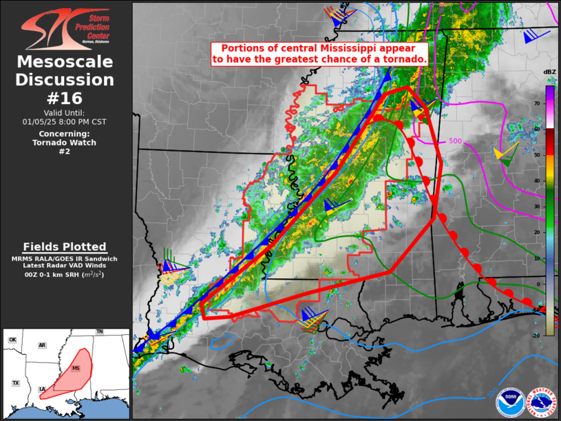
   Mesoscale Discussion 0016
   NWS Storm Prediction Center Norman OK
   0602 PM CST Sun Jan 05 2025

   Areas affected...parts of central Louisiana...much of Mississippi

   Concerning...Tornado Watch 2...

   Valid 060002Z - 060200Z

   The severe weather threat for Tornado Watch 2 continues.

   SUMMARY...A tornado or two remains possible across the watch area,
   along with locally damaging winds.

   DISCUSSION...A relatively wide squall line with embedded cells
   extends from northeast MS into central LA as of 00Z. Gusty southerly
   winds continue to bring warming northward ahead of the line, with
   the instability/theta-e axis roughly from south-central LA to near
   Jackson, MS. The warm front remains draped from eastern MS into
   southwest AL.

   Shear profiles remain strong just ahead of the cold front, with
   effective SRH of 200-400 m2/s2. Stronger low-level shear exists
   farther east into northeast MS/AL/TN, but the air mass remains
   stable for surface-based parcels at this time. Hodographs do remain
   quite favorable for supercells and tornadoes, given a discrete cell
   and/or stronger core within the line.

   Otherwise, given the relatively poor condition of the air mass even
   over the northern Gulf of Mexico (where dewpoints are only in the
   low to mid 60s F), it does not appear that appreciable instability
   will be able to develop very far east of the existing watch, at
   least over the next few hours. As such, an addition watch is not
   expected, but surface trends will continue to be monitored.

   ..Jewell.. 01/06/2025

   ...Please see www.spc.noaa.gov for graphic product...

   ATTN...WFO...BMX...MOB...MEG...JAN...LIX...LCH...

   LAT...LON   30589275 31539145 32729026 33978934 34088889 33758854
               32848825 31968842 31118925 30789078 30389222 30349269
               30589275
|


 @NWSSPC