Note:
The expiration time in the watch graphic is amended if the watch is
replaced, cancelled or extended.
Note:
Note:
The expiration time in the watch graphic is amended if the watch is
replaced, cancelled or extended.
Note: Click for
Watch Status Reports.
SEL1
URGENT - IMMEDIATE BROADCAST REQUESTED
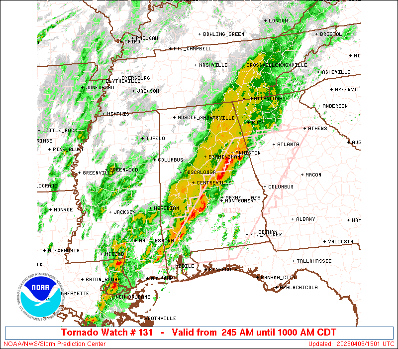
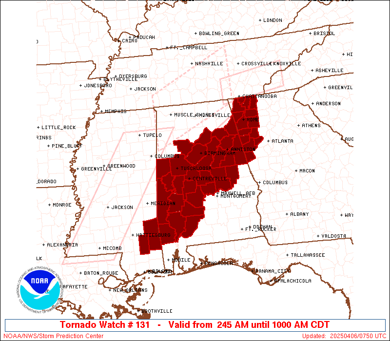
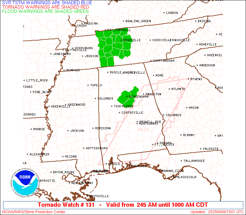
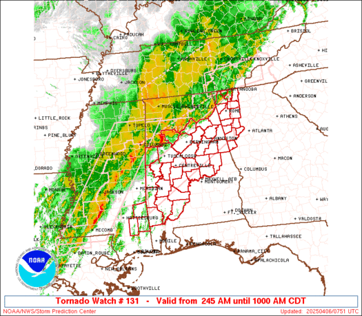
Tornado Watch Number 131
NWS Storm Prediction Center Norman OK
245 AM CDT Sun Apr 6 2025
The NWS Storm Prediction Center has issued a
* Tornado Watch for portions of
Central and Southwest Alabama
Northwest Georgia
Far Southeast Mississippi
* Effective this Sunday morning from 245 AM until 1000 AM CDT.
* Primary threats include...
A couple tornadoes possible
Scattered damaging wind gusts to 70 mph possible
SUMMARY...Thunderstorms continue to gradually move southeastward
across the Southeast States. Low-level wind fields remain strong,
supporting the potential for damaging gusts and line-embedded
tornadoes. Additionally, there is also some chance for a few storms
ahead of the main line. Environmental conditions suggest that any
persistent discrete storms could become supercellular and capable of
producing damaging gusts and tornadoes.
The tornado watch area is approximately along and 45 statute miles
north and south of a line from 135 miles southwest of Birmingham AL
to 15 miles southeast of Rome GA. For a complete depiction of the
watch see the associated watch outline update (WOUS64 KWNS WOU1).
PRECAUTIONARY/PREPAREDNESS ACTIONS...
REMEMBER...A Tornado Watch means conditions are favorable for
tornadoes and severe thunderstorms in and close to the watch
area. Persons in these areas should be on the lookout for
threatening weather conditions and listen for later statements
and possible warnings.
&&
OTHER WATCH INFORMATION...CONTINUE...WW 128...WW 129...WW 130...
AVIATION...Tornadoes and a few severe thunderstorms with hail
surface and aloft to 1.5 inches. Extreme turbulence and surface wind
gusts to 60 knots. A few cumulonimbi with maximum tops to 500. Mean
storm motion vector 24035.
...Mosier
   SEL1

   URGENT - IMMEDIATE BROADCAST REQUESTED
   Tornado Watch Number 131
   NWS Storm Prediction Center Norman OK
   245 AM CDT Sun Apr 6 2025

   The NWS Storm Prediction Center has issued a

   * Tornado Watch for portions of
     Central and Southwest Alabama
     Northwest Georgia
     Far Southeast Mississippi

   * Effective this Sunday morning from 245 AM until 1000 AM CDT.

   * Primary threats include...
     A couple tornadoes possible
     Scattered damaging wind gusts to 70 mph possible

   SUMMARY...Thunderstorms continue to gradually move southeastward
   across the Southeast States. Low-level wind fields remain strong,
   supporting the potential for damaging gusts and line-embedded
   tornadoes. Additionally, there is also some chance for a few storms
   ahead of the main line. Environmental conditions suggest that any
   persistent discrete storms could become supercellular and capable of
   producing damaging gusts and tornadoes.

   The tornado watch area is approximately along and 45 statute miles
   north and south of a line from 135 miles southwest of Birmingham AL
   to 15 miles southeast of Rome GA. For a complete depiction of the
   watch see the associated watch outline update (WOUS64 KWNS WOU1).

   PRECAUTIONARY/PREPAREDNESS ACTIONS...

   REMEMBER...A Tornado Watch means conditions are favorable for
   tornadoes and severe thunderstorms in and close to the watch
   area. Persons in these areas should be on the lookout for
   threatening weather conditions and listen for later statements
   and possible warnings.

   &&

   OTHER WATCH INFORMATION...CONTINUE...WW 128...WW 129...WW 130...

   AVIATION...Tornadoes and a few severe thunderstorms with hail
   surface and aloft to 1.5 inches. Extreme turbulence and surface wind
   gusts to 60 knots. A few cumulonimbi with maximum tops to 500. Mean
   storm motion vector 24035.

   ...Mosier
 Note:
The Aviation Watch (SAW) product is an approximation to the watch area.
The actual watch is depicted by the shaded areas.
Note:
The Aviation Watch (SAW) product is an approximation to the watch area.
The actual watch is depicted by the shaded areas.
   SAW1
   WW 131 TORNADO AL GA MS 060745Z - 061500Z
   AXIS..45 STATUTE MILES NORTH AND SOUTH OF LINE..
   135SW BHM/BIRMINGHAM AL/ - 15SE RMG/ROME GA/
   ..AVIATION COORDS.. 40NM N/S /24ESE MEI - 44NW ATL/
   HAIL SURFACE AND ALOFT..1.5 INCHES. WIND GUSTS..60 KNOTS.
   MAX TOPS TO 500. MEAN STORM MOTION VECTOR 24035.

   LAT...LON 32838838 34848498 33558498 31538838

   THIS IS AN APPROXIMATION TO THE WATCH AREA.  FOR A
   COMPLETE DEPICTION OF THE WATCH SEE WOUS64 KWNS
   FOR WOU1.
Watch 131 Status Report Messages:
STATUS REPORT #4 ON WW 131

VALID 061330Z - 061440Z

SEVERE WEATHER THREAT CONTINUES RIGHT OF A LINE FROM 45 SSE MEI
TO 35 SE MEI TO 50 ENE MEI TO 20 ESE TCL TO 10 SSW GAD TO 30 ENE
GAD TO 10 W RMG TO 20 E CHA.

..BENTLEY..04/06/25

ATTN...WFO...BMX...MOB...FFC...

&&

STATUS REPORT FOR WT 131

SEVERE WEATHER THREAT CONTINUES FOR THE FOLLOWING AREAS

ALC001-007-015-021-025-027-029-037-047-051-065-091-099-105-111-
117-121-123-129-131-061440-

AL
.    ALABAMA COUNTIES INCLUDED ARE

AUTAUGA 	     BIBB		 CALHOUN
CHILTON 	     CLARKE		 CLAY
CLEBURNE	     COOSA		 DALLAS
ELMORE		     HALE		 MARENGO
MONROE		     PERRY		 RANDOLPH
SHELBY		     TALLADEGA		 TALLAPOOSA
WASHINGTON	     WILCOX
$$


GAC015-045-055-097-115-129-143-149-223-233-061440-

GA
.    GEORGIA COUNTIES INCLUDED ARE

BARTOW		     CARROLL		 CHATTOOGA
DOUGLAS 	     FLOYD		 GORDON
HARALSON	     HEARD		 PAULDING
POLK
$$


MSC041-061440-

MS
.    MISSISSIPPI COUNTIES INCLUDED ARE

GREENE
$$


THE WATCH STATUS MESSAGE IS FOR GUIDANCE PURPOSES ONLY.  PLEASE
REFER TO WATCH COUNTY NOTIFICATION STATEMENTS FOR OFFICIAL
INFORMATION ON COUNTIES...INDEPENDENT CITIES AND MARINE ZONES
CLEARED FROM SEVERE THUNDERSTORM AND TORNADO WATCHES.
$$

STATUS REPORT #3 ON WW 131

VALID 061150Z - 061240Z

THE SEVERE WEATHER THREAT CONTINUES ACROSS THE ENTIRE WATCH AREA.

..KERR..04/06/25

ATTN...WFO...BMX...MOB...FFC...

&&

STATUS REPORT FOR WT 131

SEVERE WEATHER THREAT CONTINUES FOR THE FOLLOWING AREAS

ALC001-007-009-015-019-021-023-025-027-029-037-047-051-055-063-
065-073-091-099-105-111-115-117-119-121-123-125-129-131-
061240-

AL
.    ALABAMA COUNTIES INCLUDED ARE

AUTAUGA 	     BIBB		 BLOUNT
CALHOUN 	     CHEROKEE		 CHILTON
CHOCTAW 	     CLARKE		 CLAY
CLEBURNE	     COOSA		 DALLAS
ELMORE		     ETOWAH		 GREENE
HALE		     JEFFERSON		 MARENGO
MONROE		     PERRY		 RANDOLPH
ST. CLAIR	     SHELBY		 SUMTER
TALLADEGA	     TALLAPOOSA 	 TUSCALOOSA
WASHINGTON	     WILCOX
$$


GAC015-045-047-055-097-115-129-143-149-213-223-233-295-313-
061240-

GA
.    GEORGIA COUNTIES INCLUDED ARE

BARTOW		     CARROLL		 CATOOSA
CHATTOOGA	     DOUGLAS		 FLOYD
GORDON		     HARALSON		 HEARD
MURRAY		     PAULDING		 POLK
WALKER		     WHITFIELD
$$


MSC041-111-153-061240-

MS
.    MISSISSIPPI COUNTIES INCLUDED ARE

GREENE		     PERRY		 WAYNE
$$


THE WATCH STATUS MESSAGE IS FOR GUIDANCE PURPOSES ONLY.  PLEASE
REFER TO WATCH COUNTY NOTIFICATION STATEMENTS FOR OFFICIAL
INFORMATION ON COUNTIES...INDEPENDENT CITIES AND MARINE ZONES
CLEARED FROM SEVERE THUNDERSTORM AND TORNADO WATCHES.
$$

STATUS REPORT #2 ON WW 131

VALID 061045Z - 061140Z

THE SEVERE WEATHER THREAT CONTINUES ACROSS THE ENTIRE WATCH AREA.

..KERR..04/06/25

ATTN...WFO...BMX...MOB...FFC...

&&

STATUS REPORT FOR WT 131

SEVERE WEATHER THREAT CONTINUES FOR THE FOLLOWING AREAS

ALC001-007-009-015-019-021-023-025-027-029-037-047-051-055-063-
065-073-091-099-105-111-115-117-119-121-123-125-129-131-
061140-

AL
.    ALABAMA COUNTIES INCLUDED ARE

AUTAUGA 	     BIBB		 BLOUNT
CALHOUN 	     CHEROKEE		 CHILTON
CHOCTAW 	     CLARKE		 CLAY
CLEBURNE	     COOSA		 DALLAS
ELMORE		     ETOWAH		 GREENE
HALE		     JEFFERSON		 MARENGO
MONROE		     PERRY		 RANDOLPH
ST. CLAIR	     SHELBY		 SUMTER
TALLADEGA	     TALLAPOOSA 	 TUSCALOOSA
WASHINGTON	     WILCOX
$$


GAC015-045-047-055-097-115-129-143-149-213-223-233-295-313-
061140-

GA
.    GEORGIA COUNTIES INCLUDED ARE

BARTOW		     CARROLL		 CATOOSA
CHATTOOGA	     DOUGLAS		 FLOYD
GORDON		     HARALSON		 HEARD
MURRAY		     PAULDING		 POLK
WALKER		     WHITFIELD
$$


MSC041-111-153-061140-

MS
.    MISSISSIPPI COUNTIES INCLUDED ARE

GREENE		     PERRY		 WAYNE
$$


THE WATCH STATUS MESSAGE IS FOR GUIDANCE PURPOSES ONLY.  PLEASE
REFER TO WATCH COUNTY NOTIFICATION STATEMENTS FOR OFFICIAL
INFORMATION ON COUNTIES...INDEPENDENT CITIES AND MARINE ZONES
CLEARED FROM SEVERE THUNDERSTORM AND TORNADO WATCHES.
$$

STATUS REPORT #1 ON WW 131

VALID 060930Z - 061040Z

THE SEVERE WEATHER THREAT CONTINUES ACROSS THE ENTIRE WATCH AREA.

..KERR..04/06/25

ATTN...WFO...BMX...MOB...FFC...

&&

STATUS REPORT FOR WT 131

SEVERE WEATHER THREAT CONTINUES FOR THE FOLLOWING AREAS

ALC001-007-009-015-019-021-023-025-027-029-037-047-051-055-063-
065-073-091-099-105-107-111-115-117-119-121-123-125-127-129-131-
061040-

AL
.    ALABAMA COUNTIES INCLUDED ARE

AUTAUGA 	     BIBB		 BLOUNT
CALHOUN 	     CHEROKEE		 CHILTON
CHOCTAW 	     CLARKE		 CLAY
CLEBURNE	     COOSA		 DALLAS
ELMORE		     ETOWAH		 GREENE
HALE		     JEFFERSON		 MARENGO
MONROE		     PERRY		 PICKENS
RANDOLPH	     ST. CLAIR		 SHELBY
SUMTER		     TALLADEGA		 TALLAPOOSA
TUSCALOOSA	     WALKER		 WASHINGTON
WILCOX
$$


GAC015-045-047-055-097-115-129-143-149-213-223-233-295-313-
061040-

GA
.    GEORGIA COUNTIES INCLUDED ARE

BARTOW		     CARROLL		 CATOOSA
CHATTOOGA	     DOUGLAS		 FLOYD
GORDON		     HARALSON		 HEARD
MURRAY		     PAULDING		 POLK
WALKER		     WHITFIELD
$$


MSC041-111-153-061040-

MS
.    MISSISSIPPI COUNTIES INCLUDED ARE

GREENE		     PERRY		 WAYNE
$$


THE WATCH STATUS MESSAGE IS FOR GUIDANCE PURPOSES ONLY.  PLEASE
REFER TO WATCH COUNTY NOTIFICATION STATEMENTS FOR OFFICIAL
INFORMATION ON COUNTIES...INDEPENDENT CITIES AND MARINE ZONES
CLEARED FROM SEVERE THUNDERSTORM AND TORNADO WATCHES.
$$
Note:
Click for Complete Product Text.
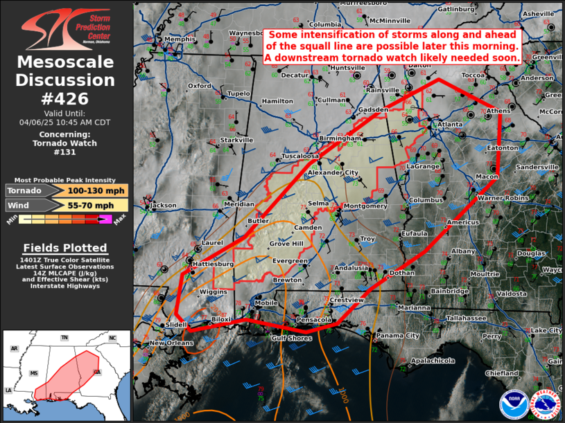
Tornadoes
Probability of 2 or more tornadoes
|
Mod (40%)
|
Probability of 1 or more strong (EF2-EF5) tornadoes
|
Low (20%)
|
Wind
Probability of 10 or more severe wind events
|
Mod (50%)
|
Probability of 1 or more wind events > 65 knots
|
Low (20%)
|
Hail
Probability of 10 or more severe hail events
|
Low (<5%)
|
Probability of 1 or more hailstones > 2 inches
|
Low (<5%)
|
Combined Severe Hail/Wind
Probability of 6 or more combined severe hail/wind events
|
Mod (60%)
|
For each watch, probabilities for particular events inside the watch
(listed above in each table) are determined by the issuing forecaster.
The "Low" category contains probability values ranging from less than 2%
to 20% (EF2-EF5 tornadoes), less than 5% to 20% (all other probabilities),
"Moderate" from 30% to 60%, and "High" from 70% to greater than 95%.
High values are bolded and lighter in color to provide awareness of
an increased threat for a particular event.


 @NWSSPC