Note:
The expiration time in the watch graphic is amended if the watch is
replaced, cancelled or extended.
Note:
Note:
The expiration time in the watch graphic is amended if the watch is
replaced, cancelled or extended.
Note: Click for
Watch Status Reports.
SEL0
URGENT - IMMEDIATE BROADCAST REQUESTED
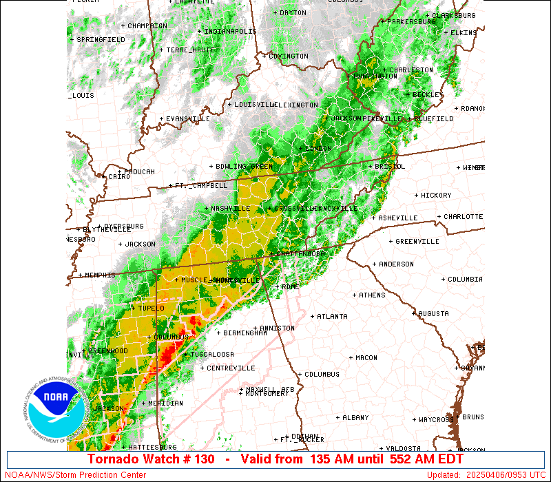
Tornado Watch Number 130
NWS Storm Prediction Center Norman OK
135 AM EDT Sun Apr 6 2025
The NWS Storm Prediction Center has issued a
* Tornado Watch for portions of
Far Western North Carolina
Southeastern Tennessee
* Effective this Sunday morning from 135 AM until 700 AM EDT.
* Primary threats include...
A couple tornadoes possible
Isolated damaging wind gusts to 70 mph possible
SUMMARY...Convective line currently moving through middle TN is
expected to continue eastward into southeastern TN and eventually
far western NC over the next several hours. Low-level shear across
the region is expected to remain strong enough to support occasional
bowing within this line, with an attendant threat for damaging gusts
and a few tornadoes.
The tornado watch area is approximately along and 25 statute miles
north and south of a line from 35 miles west northwest of
Chattanooga TN to 30 miles southeast of Knoxville TN. For a complete
depiction of the watch see the associated watch outline update
(WOUS64 KWNS WOU0).
PRECAUTIONARY/PREPAREDNESS ACTIONS...
REMEMBER...A Tornado Watch means conditions are favorable for
tornadoes and severe thunderstorms in and close to the watch
area. Persons in these areas should be on the lookout for
threatening weather conditions and listen for later statements
and possible warnings.
&&
OTHER WATCH INFORMATION...CONTINUE...WW 128...WW 129...
AVIATION...Tornadoes and a few severe thunderstorms with hail
surface and aloft to 1.5 inches. Extreme turbulence and surface wind
gusts to 60 knots. A few cumulonimbi with maximum tops to 500. Mean
storm motion vector 24035.
...Mosier

SEL0
URGENT - IMMEDIATE BROADCAST REQUESTED
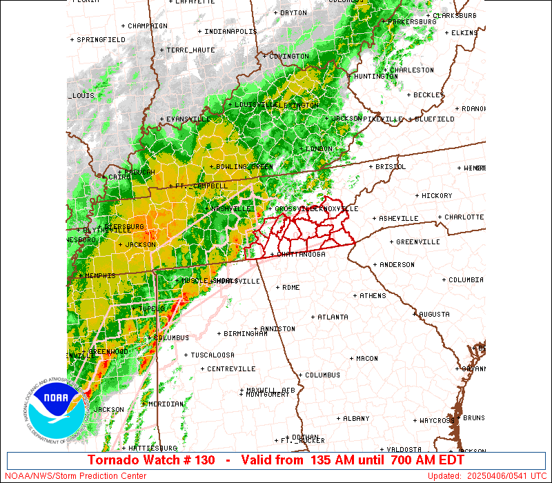
Tornado Watch Number 130
NWS Storm Prediction Center Norman OK
135 AM EDT Sun Apr 6 2025
The NWS Storm Prediction Center has issued a
* Tornado Watch for portions of
Far Western North Carolina
Southeastern Tennessee
* Effective this Sunday morning from 135 AM until 700 AM EDT.
* Primary threats include...
A couple tornadoes possible
Isolated damaging wind gusts to 70 mph possible
SUMMARY...Convective line currently moving through middle TN is
expected to continue eastward into southeastern TN and eventually
far western NC over the next several hours. Low-level shear across
the region is expected to remain strong enough to support occasional
bowing within this line, with an attendant threat for damaging gusts
and a few tornadoes.
The tornado watch area is approximately along and 25 statute miles
north and south of a line from 35 miles west northwest of
Chattanooga TN to 30 miles southeast of Knoxville TN. For a complete
depiction of the watch see the associated watch outline update
(WOUS64 KWNS WOU0).
PRECAUTIONARY/PREPAREDNESS ACTIONS...
REMEMBER...A Tornado Watch means conditions are favorable for
tornadoes and severe thunderstorms in and close to the watch
area. Persons in these areas should be on the lookout for
threatening weather conditions and listen for later statements
and possible warnings.
&&
OTHER WATCH INFORMATION...CONTINUE...WW 128...WW 129...
AVIATION...Tornadoes and a few severe thunderstorms with hail
surface and aloft to 1.5 inches. Extreme turbulence and surface wind
gusts to 60 knots. A few cumulonimbi with maximum tops to 500. Mean
storm motion vector 24035.
...Mosier
 Note:
The Aviation Watch (SAW) product is an approximation to the watch area.
The actual watch is depicted by the shaded areas.
Note:
The Aviation Watch (SAW) product is an approximation to the watch area.
The actual watch is depicted by the shaded areas.
   SAW0
   WW 130 TORNADO NC TN 060535Z - 061100Z
   AXIS..25 STATUTE MILES NORTH AND SOUTH OF LINE..
   35WNW CHA/CHATTANOOGA TN/ - 30SE TYS/KNOXVILLE TN/
   ..AVIATION COORDS.. 20NM N/S /34WNW GQO - 27SSE VXV/
   HAIL SURFACE AND ALOFT..1.5 INCHES. WIND GUSTS..60 KNOTS.
   MAX TOPS TO 500. MEAN STORM MOTION VECTOR 24035.

   LAT...LON 35588577 35878362 35158362 34868577

   THIS IS AN APPROXIMATION TO THE WATCH AREA.  FOR A
   COMPLETE DEPICTION OF THE WATCH SEE WOUS64 KWNS
   FOR WOU0.
Watch 130 Status Report Messages:
STATUS REPORT #4 ON WW 130

VALID 060925Z - 061040Z

SEVERE WEATHER THREAT CONTINUES RIGHT OF A LINE FROM 50 S TYS TO
40 SSE TYS.

..KERR..04/06/25

ATTN...WFO...MRX...GSP...

&&

STATUS REPORT FOR WT 130

SEVERE WEATHER THREAT CONTINUES FOR THE FOLLOWING AREAS

NCC043-113-061040-

NC
.    NORTH CAROLINA COUNTIES INCLUDED ARE

CLAY		     MACON
$$


THE WATCH STATUS MESSAGE IS FOR GUIDANCE PURPOSES ONLY.  PLEASE
REFER TO WATCH COUNTY NOTIFICATION STATEMENTS FOR OFFICIAL
INFORMATION ON COUNTIES...INDEPENDENT CITIES AND MARINE ZONES
CLEARED FROM SEVERE THUNDERSTORM AND TORNADO WATCHES.
$$

STATUS REPORT #3 ON WW 130

VALID 060830Z - 060940Z

SEVERE WEATHER THREAT CONTINUES RIGHT OF A LINE FROM 50 E CHA TO
30 SE TYS.

..KERR..04/06/25

ATTN...WFO...MRX...GSP...

&&

STATUS REPORT FOR WT 130

SEVERE WEATHER THREAT CONTINUES FOR THE FOLLOWING AREAS

NCC039-043-075-113-173-060940-

NC
.    NORTH CAROLINA COUNTIES INCLUDED ARE

CHEROKEE	     CLAY		 GRAHAM
MACON		     SWAIN
$$


TNC139-060940-

TN
.    TENNESSEE COUNTIES INCLUDED ARE

POLK
$$


THE WATCH STATUS MESSAGE IS FOR GUIDANCE PURPOSES ONLY.  PLEASE
REFER TO WATCH COUNTY NOTIFICATION STATEMENTS FOR OFFICIAL
INFORMATION ON COUNTIES...INDEPENDENT CITIES AND MARINE ZONES
CLEARED FROM SEVERE THUNDERSTORM AND TORNADO WATCHES.
$$

STATUS REPORT #2 ON WW 130

VALID 060730Z - 060840Z

SEVERE WEATHER THREAT CONTINUES RIGHT OF A LINE FROM 5 SE CHA TO
25 W TYS.

..KERR..04/06/25

ATTN...WFO...MRX...GSP...

&&

STATUS REPORT FOR WT 130

SEVERE WEATHER THREAT CONTINUES FOR THE FOLLOWING AREAS

NCC039-043-075-113-173-060840-

NC
.    NORTH CAROLINA COUNTIES INCLUDED ARE

CHEROKEE	     CLAY		 GRAHAM
MACON		     SWAIN
$$


TNC009-011-065-105-107-121-123-139-155-060840-

TN
.    TENNESSEE COUNTIES INCLUDED ARE

BLOUNT		     BRADLEY		 HAMILTON
LOUDON		     MCMINN		 MEIGS
MONROE		     POLK		 SEVIER
$$


THE WATCH STATUS MESSAGE IS FOR GUIDANCE PURPOSES ONLY.  PLEASE
REFER TO WATCH COUNTY NOTIFICATION STATEMENTS FOR OFFICIAL
INFORMATION ON COUNTIES...INDEPENDENT CITIES AND MARINE ZONES
CLEARED FROM SEVERE THUNDERSTORM AND TORNADO WATCHES.
$$

STATUS REPORT #1 ON WW 130

VALID 060650Z - 060740Z

SEVERE WEATHER THREAT CONTINUES RIGHT OF A LINE FROM 15 WSW CHA
TO 25 ESE CSV.

..KERR..04/06/25

ATTN...WFO...MRX...GSP...

&&

STATUS REPORT FOR WT 130

SEVERE WEATHER THREAT CONTINUES FOR THE FOLLOWING AREAS

NCC039-043-075-113-173-060740-

NC
.    NORTH CAROLINA COUNTIES INCLUDED ARE

CHEROKEE	     CLAY		 GRAHAM
MACON		     SWAIN
$$


TNC007-009-011-065-105-107-121-123-139-143-153-155-060740-

TN
.    TENNESSEE COUNTIES INCLUDED ARE

BLEDSOE 	     BLOUNT		 BRADLEY
HAMILTON	     LOUDON		 MCMINN
MEIGS		     MONROE		 POLK
RHEA		     SEQUATCHIE 	 SEVIER
$$


THE WATCH STATUS MESSAGE IS FOR GUIDANCE PURPOSES ONLY.  PLEASE
REFER TO WATCH COUNTY NOTIFICATION STATEMENTS FOR OFFICIAL
INFORMATION ON COUNTIES...INDEPENDENT CITIES AND MARINE ZONES
CLEARED FROM SEVERE THUNDERSTORM AND TORNADO WATCHES.
$$
Note:
Click for Complete Product Text.
Tornadoes
Probability of 2 or more tornadoes
|
Mod (30%)
|
Probability of 1 or more strong (EF2-EF5) tornadoes
|
Low (10%)
|
Wind
Probability of 10 or more severe wind events
|
Low (20%)
|
Probability of 1 or more wind events > 65 knots
|
Low (10%)
|
Hail
Probability of 10 or more severe hail events
|
Low (10%)
|
Probability of 1 or more hailstones > 2 inches
|
Low (10%)
|
Combined Severe Hail/Wind
Probability of 6 or more combined severe hail/wind events
|
Mod (40%)
|
For each watch, probabilities for particular events inside the watch
(listed above in each table) are determined by the issuing forecaster.
The "Low" category contains probability values ranging from less than 2%
to 20% (EF2-EF5 tornadoes), less than 5% to 20% (all other probabilities),
"Moderate" from 30% to 60%, and "High" from 70% to greater than 95%.
High values are bolded and lighter in color to provide awareness of
an increased threat for a particular event.


 @NWSSPC