|
| Mesoscale Discussion 424 |
|
[an error occurred while processing this directive]
|
|
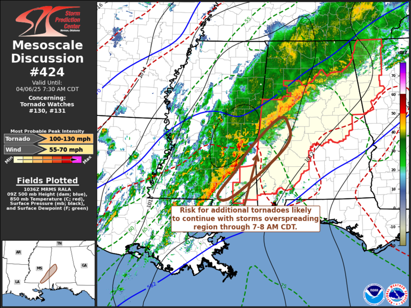
   Mesoscale Discussion 0424
   NWS Storm Prediction Center Norman OK
   0537 AM CDT Sun Apr 06 2025

   Areas affected...lparts of sern MS into cntrl AL

   Concerning...Tornado Watch 130...131...

   Valid 061037Z - 061230Z

   The severe weather threat for Tornado Watch 130, 131 continues.

   SUMMARY...Storms overspreading areas near/northeast of Pine Belt MS
   into areas near/south of Tuscaloosa AL will pose a risk for
   producing additional tornadoes through 7-8 AM CDT.

   DISCUSSION...Several meso-beta to meso-gamma scale circulations have
   evolved along the gust front slowly advancing eastward through
   southeastern Mississippi, with 2-hourly surface pressure falls in
   excess of 2 mb noted on the Pine Belt MS surface observations the
   past couple of hours.  A couple of these circulations appear to have
   briefly intensified to tornadic strength, based on storm-relative
   velocity data and debris signatures.  Supported by southeasterly
   updraft inflow emanating from a narrow corridor of moderately large
   CAPE across southeastern Mississippi into portions of west central
   Alabama (where surface dew points remain near 70f), it appears that
   this activity may maintain strength while gradually spreading
   eastward through 11-13Z.

   Intensification of one or two additional discrete cells just ahead
   of the line also appears possible near/east to northeast of Pine
   Belt during the next couple of hours, accompanied by potential to
   produce a tornado in the presence of sizable clockwise-curved
   low-level hodographs.

   ..Kerr.. 04/06/2025

   ...Please see www.spc.noaa.gov for graphic product...

   ATTN...WFO...BMX...MOB...JAN...

   LAT...LON   33038780 32928752 32328758 31108911 31098959 31758903
               32268867 33038780

   MOST PROBABLE PEAK TORNADO INTENSITY...100-130 MPH
   MOST PROBABLE PEAK WIND GUST...55-70 MPH
|
|
Top/All Mesoscale Discussions/Forecast Products/Home
|
|


 @NWSSPC