 Note:
The expiration time in the watch graphic is amended if the watch is
replaced, cancelled or extended.
Note:
Note:
The expiration time in the watch graphic is amended if the watch is
replaced, cancelled or extended.
Note: Click for
Watch Status Reports.
SEL2
URGENT - IMMEDIATE BROADCAST REQUESTED
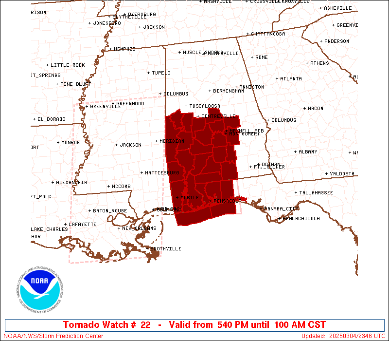
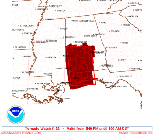
Tornado Watch Number 22
NWS Storm Prediction Center Norman OK
540 PM CST Tue Mar 4 2025
The NWS Storm Prediction Center has issued a
* Tornado Watch for portions of
Southern and South-Central Alabama
Western Florida Panhandle
Coastal Waters
* Effective this Tuesday afternoon and Wednesday morning from 540
PM until 100 AM CST.
* Primary threats include...
A few tornadoes likely with a couple intense tornadoes possible
Scattered damaging winds likely with isolated significant gusts
to 80 mph possible
Isolated large hail events to 1 inch in diameter possible
SUMMARY...Severe storm potential including the risk for tornadoes
will increase through early/mid-evening especially across southwest
Alabama, and eventually parts of the western Florida Panhandle and
south-central Alabama.
The tornado watch area is approximately along and 95 statute miles
north and south of a line from 60 miles north of Mobile AL to 45
miles north northeast of Crestview FL. For a complete depiction of
the watch see the associated watch outline update (WOUS64 KWNS
WOU2).
PRECAUTIONARY/PREPAREDNESS ACTIONS...
REMEMBER...A Tornado Watch means conditions are favorable for
tornadoes and severe thunderstorms in and close to the watch
area. Persons in these areas should be on the lookout for
threatening weather conditions and listen for later statements
and possible warnings.
&&
OTHER WATCH INFORMATION...CONTINUE...WW 21...
AVIATION...Tornadoes and a few severe thunderstorms with hail
surface and aloft to 1 inch. Extreme turbulence and surface wind
gusts to 70 knots. A few cumulonimbi with maximum tops to 500. Mean
storm motion vector 23035.
...Guyer
   SEL2

   URGENT - IMMEDIATE BROADCAST REQUESTED
   Tornado Watch Number 22
   NWS Storm Prediction Center Norman OK
   540 PM CST Tue Mar 4 2025

   The NWS Storm Prediction Center has issued a

   * Tornado Watch for portions of
     Southern and South-Central Alabama
     Western Florida Panhandle
     Coastal Waters

   * Effective this Tuesday afternoon and Wednesday morning from 540
     PM until 100 AM CST.

   * Primary threats include...
     A few tornadoes likely with a couple intense tornadoes possible
     Scattered damaging winds likely with isolated significant gusts
       to 80 mph possible
     Isolated large hail events to 1 inch in diameter possible

   SUMMARY...Severe storm potential including the risk for tornadoes
   will increase through early/mid-evening especially across southwest
   Alabama, and eventually parts of the western Florida Panhandle and
   south-central Alabama.

   The tornado watch area is approximately along and 95 statute miles
   north and south of a line from 60 miles north of Mobile AL to 45
   miles north northeast of Crestview FL. For a complete depiction of
   the watch see the associated watch outline update (WOUS64 KWNS
   WOU2).

   PRECAUTIONARY/PREPAREDNESS ACTIONS...

   REMEMBER...A Tornado Watch means conditions are favorable for
   tornadoes and severe thunderstorms in and close to the watch
   area. Persons in these areas should be on the lookout for
   threatening weather conditions and listen for later statements
   and possible warnings.

   &&

   OTHER WATCH INFORMATION...CONTINUE...WW 21...

   AVIATION...Tornadoes and a few severe thunderstorms with hail
   surface and aloft to 1 inch. Extreme turbulence and surface wind
   gusts to 70 knots. A few cumulonimbi with maximum tops to 500. Mean
   storm motion vector 23035.

   ...Guyer
 Note:
The Aviation Watch (SAW) product is an approximation to the watch area.
The actual watch is depicted by the shaded areas.
Note:
The Aviation Watch (SAW) product is an approximation to the watch area.
The actual watch is depicted by the shaded areas.
   SAW2
   WW 22 TORNADO AL FL CW 042340Z - 050700Z
   AXIS..95 STATUTE MILES NORTH AND SOUTH OF LINE..
   60N MOB/MOBILE AL/ - 45NNE CEW/CRESTVIEW FL/
   ..AVIATION COORDS.. 80NM N/S /49N SJI - 40NE CEW/
   HAIL SURFACE AND ALOFT..1 INCH. WIND GUSTS..70 KNOTS.
   MAX TOPS TO 500. MEAN STORM MOTION VECTOR 23035.

   LAT...LON 32918825 32758623 30018623 30178825

   THIS IS AN APPROXIMATION TO THE WATCH AREA.  FOR A
   COMPLETE DEPICTION OF THE WATCH SEE WOUS64 KWNS
   FOR WOU2.
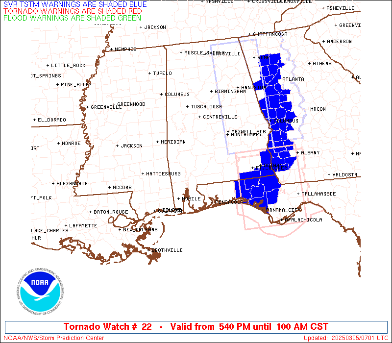
Watch 22 Status Report Messages:
STATUS REPORT #2 ON WW 22

VALID 050455Z - 050540Z

SEVERE WEATHER THREAT CONTINUES RIGHT OF A LINE FROM 35 SW PNS TO
10 E MGM.

..SPC..03/05/25

ATTN...WFO...BMX...MOB...

&&

STATUS REPORT FOR WT 22

SEVERE WEATHER THREAT CONTINUES FOR THE FOLLOWING AREAS

ALC013-035-039-041-051-053-101-050540-

AL
.    ALABAMA COUNTIES INCLUDED ARE

BUTLER		     CONECUH		 COVINGTON
CRENSHAW	     ELMORE		 ESCAMBIA
MONTGOMERY
$$


FLC033-091-113-050540-

FL
.    FLORIDA COUNTIES INCLUDED ARE

ESCAMBIA	     OKALOOSA		 SANTA ROSA
$$


GMZ633-634-635-636-650-655-050540-

CW

.    ADJACENT COASTAL WATERS INCLUDED ARE

PERDIDO BAY AREA

PENSACOLA BAY AREA INCLUDING SANTA ROSA SOUND

WESTERN CHOCTAWHATCHEE BAY

EASTERN CHOCTAWHATCHEE BAY

COASTAL WATERS FROM PENSACOLA FL TO PASCAGOULA MS OUT 20 NM

COASTAL WATERS FROM OKALOOSA-WALTON COUNTY LINE TO PENSACOLA FL
OUT 20 NM

$$
THE WATCH STATUS MESSAGE IS FOR GUIDANCE PURPOSES ONLY.  PLEASE
REFER TO WATCH COUNTY NOTIFICATION STATEMENTS FOR OFFICIAL
INFORMATION ON COUNTIES...INDEPENDENT CITIES AND MARINE ZONES
CLEARED FROM SEVERE THUNDERSTORM AND TORNADO WATCHES.
$$

STATUS REPORT #1 ON WW 22

VALID 050230Z - 050340Z

SEVERE WEATHER THREAT CONTINUES RIGHT OF A LINE FROM 20 NNW MOB
TO 35 WSW SEM TO 25 SSE TCL.

..SPC..03/05/25

ATTN...WFO...BMX...MOB...

&&

STATUS REPORT FOR WT 22

SEVERE WEATHER THREAT CONTINUES FOR THE FOLLOWING AREAS

ALC001-003-013-021-025-035-039-041-047-051-053-065-085-097-099-
101-105-129-131-050340-

AL
.    ALABAMA COUNTIES INCLUDED ARE

AUTAUGA 	     BALDWIN		 BUTLER
CHILTON 	     CLARKE		 CONECUH
COVINGTON	     CRENSHAW		 DALLAS
ELMORE		     ESCAMBIA		 HALE
LOWNDES 	     MOBILE		 MONROE
MONTGOMERY	     PERRY		 WASHINGTON
WILCOX
$$


FLC033-091-113-050340-

FL
.    FLORIDA COUNTIES INCLUDED ARE

ESCAMBIA	     OKALOOSA		 SANTA ROSA
$$


GMZ630-631-632-633-634-635-636-650-655-050340-

CW

.    ADJACENT COASTAL WATERS INCLUDED ARE

NORTH MOBILE BAY

SOUTH MOBILE BAY

MISSISSIPPI SOUND

PERDIDO BAY AREA

PENSACOLA BAY AREA INCLUDING SANTA ROSA SOUND

WESTERN CHOCTAWHATCHEE BAY

EASTERN CHOCTAWHATCHEE BAY

COASTAL WATERS FROM PENSACOLA FL TO PASCAGOULA MS OUT 20 NM

COASTAL WATERS FROM OKALOOSA-WALTON COUNTY LINE TO PENSACOLA FL
OUT 20 NM

$$
THE WATCH STATUS MESSAGE IS FOR GUIDANCE PURPOSES ONLY.  PLEASE
REFER TO WATCH COUNTY NOTIFICATION STATEMENTS FOR OFFICIAL
INFORMATION ON COUNTIES...INDEPENDENT CITIES AND MARINE ZONES
CLEARED FROM SEVERE THUNDERSTORM AND TORNADO WATCHES.
$$
Note:
Click for Complete Product Text.
Tornadoes
Probability of 2 or more tornadoes
|
Mod (60%)
|
Probability of 1 or more strong (EF2-EF5) tornadoes
|
Mod (40%)
|
Wind
Probability of 10 or more severe wind events
|
Mod (60%)
|
Probability of 1 or more wind events > 65 knots
|
Mod (50%)
|
Hail
Probability of 10 or more severe hail events
|
Low (20%)
|
Probability of 1 or more hailstones > 2 inches
|
Low (<5%)
|
Combined Severe Hail/Wind
Probability of 6 or more combined severe hail/wind events
|
High (90%)
|
For each watch, probabilities for particular events inside the watch
(listed above in each table) are determined by the issuing forecaster.
The "Low" category contains probability values ranging from less than 2%
to 20% (EF2-EF5 tornadoes), less than 5% to 20% (all other probabilities),
"Moderate" from 30% to 60%, and "High" from 70% to greater than 95%.
High values are bolded and lighter in color to provide awareness of
an increased threat for a particular event.


 @NWSSPC