|
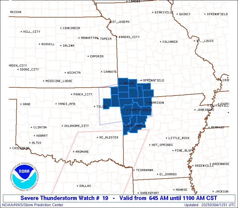
Initial List of Counties in SPC Severe Thunderstorm Watch 19 (WOU)
|
Back to Watch 19
|
 |
   WOUS64 KWNS 041241
   WOU9

   BULLETIN - IMMEDIATE BROADCAST REQUESTED
   SEVERE THUNDERSTORM WATCH OUTLINE UPDATE FOR WS 19
   NWS STORM PREDICTION CENTER NORMAN OK
   645 AM CST TUE MAR 4 2025

   SEVERE THUNDERSTORM WATCH 19 IS IN EFFECT UNTIL 1100 AM CST
   FOR THE FOLLOWING LOCATIONS

   ARC007-009-015-033-047-071-083-087-101-131-143-041700-
   /O.NEW.KWNS.SV.A.0019.250304T1245Z-250304T1700Z/

   AR
   .    ARKANSAS COUNTIES INCLUDED ARE

   BENTON               BOONE               CARROLL
   CRAWFORD             FRANKLIN            JOHNSON
   LOGAN                MADISON             NEWTON
   SEBASTIAN            WASHINGTON


   MOC009-043-097-109-119-145-209-213-041700-
   /O.NEW.KWNS.SV.A.0019.250304T1245Z-250304T1700Z/

   MO
   .    MISSOURI COUNTIES INCLUDED ARE

   BARRY                CHRISTIAN           JASPER
   LAWRENCE             MCDONALD            NEWTON
   STONE                TANEY


   OKC041-097-115-041700-
   /O.NEW.KWNS.SV.A.0019.250304T1245Z-250304T1700Z/

   OK
   .    OKLAHOMA COUNTIES INCLUDED ARE

   DELAWARE             MAYES               OTTAWA


   ATTN...WFO...TSA...SGF...LZK...
|
| Aviation Watch (SAW) for WW19 |
|---|
 |
| Note:
The Aviation Watch (SAW) product is an approximation to the watch area.
The actual watch is depicted by the shaded areas. |
   SAW9
   WW 19 SEVERE TSTM AR MO OK 041245Z - 041700Z
   AXIS..55 STATUTE MILES NORTH AND SOUTH OF LINE..
   40NNW MKO/MUSKOGEE OK/ - 20NE HRO/HARRISON AR/
   ..AVIATION COORDS.. 50NM N/S /7E TUL - 57SSE SGF/
   HAIL SURFACE AND ALOFT..1 INCH. WIND GUSTS..60 KNOTS.
   MAX TOPS TO 350. MEAN STORM MOTION VECTOR 23040.

   LAT...LON 37009564 37279290 35689290 35419564

   THIS IS AN APPROXIMATION TO THE WATCH AREA.  FOR A
   COMPLETE DEPICTION OF THE WATCH SEE WOUS64 KWNS
   FOR WOU9.
|
|


 @NWSSPC