|
| Mesoscale Discussion 100 |
|
[an error occurred while processing this directive]
|
|
Mesoscale Discussion 0100
NWS Storm Prediction Center Norman OK
0609 PM CST Sat Feb 15 2025
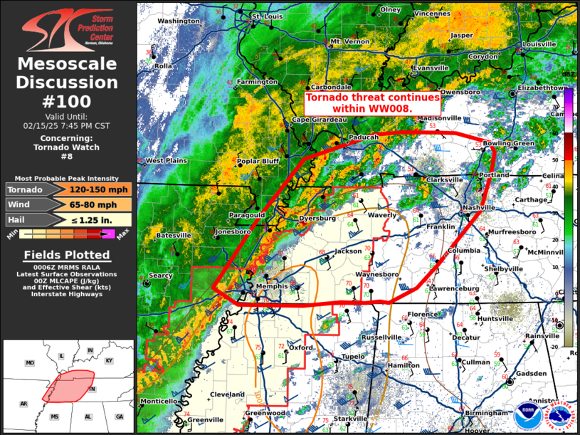
Areas affected...western Tennessee and southwestern Kentucky
Concerning...Tornado Watch 8...
Valid 160009Z - 160145Z
The severe weather threat for Tornado Watch 8 continues.
SUMMARY...Tornado threat continues within WW008. Threat will
continue downstream into portions of Middle Tennessee and Western
Kentucky.
DISCUSSION...A broken line of thunderstorms has shown an uptick in
intensity over the last hour across the Arkansas/Tennessee border.
Line embedded supercells are observed, with activity ahead of the
main line also exhibiting rotation. The low level jet, with axis
currently from central LA to middle TN/southern KY, is progged to
continue strengthening through the evening, with low level shear
becoming more favorable. This strong southerly flow has also ushered
in deeper moisture and a more favorable air mass across western
Tennessee, steadily approaching southern Kentucky.
Given the progress of the main line, maintenance of individual cells
ahead of the line will be difficult. However, deep layer shear of
50-55 kts will continue to support line embedded mesocyclones and
potential for damaging wind and tornadoes. This threat is spreading
eastward and will likely necessitate a downstream watch into
southern Kentucky soon.
..Thornton/Hart.. 02/16/2025
...Please see www.spc.noaa.gov for graphic product...
ATTN...WFO...LMK...OHX...PAH...MEG...
LAT...LON 35189070 36118999 36868928 37178815 37208772 37198710
37198685 37058629 36928623 36678629 36198647 35498716
35198750 35018794 35038807 35018830 35028869 34968928
34979029 35189070
|
|
Top/All Mesoscale Discussions/Forecast Products/Home
|
|


 @NWSSPC