 Note:
The expiration time in the watch graphic is amended if the watch is
replaced, cancelled or extended.
Note:
Note:
The expiration time in the watch graphic is amended if the watch is
replaced, cancelled or extended.
Note: Click for
Watch Status Reports.
SEL0
URGENT - IMMEDIATE BROADCAST REQUESTED
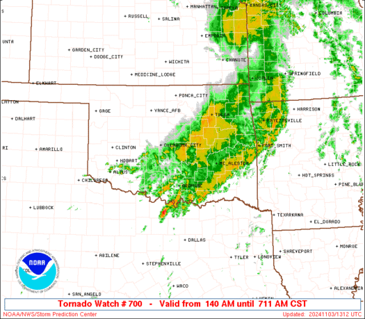
Tornado Watch Number 700
NWS Storm Prediction Center Norman OK
140 AM CST Sun Nov 3 2024
The NWS Storm Prediction Center has issued a
* Tornado Watch for portions of
Central and eastern Oklahoma
A small part of northwest Texas
* Effective this Sunday morning from 140 AM until 900 AM CST.
* Primary threats include...
A few tornadoes possible
Isolated very large hail events to 2 inches in diameter possible
Isolated damaging wind gusts to 70 mph possible
SUMMARY...Previously and potentially tornadic supercells over parts
of central and southern OK ultimately will be absorbed by a squall
line, which itself will pose a tornado and severe-gust threat as it
moves into a favorable shear/buoyancy environment this morning.
The tornado watch area is approximately along and 65 statute miles
east and west of a line from 40 miles southwest of Ardmore OK to 15
miles east northeast of Tulsa OK. For a complete depiction of the
watch see the associated watch outline update (WOUS64 KWNS WOU0).
PRECAUTIONARY/PREPAREDNESS ACTIONS...
REMEMBER...A Tornado Watch means conditions are favorable for
tornadoes and severe thunderstorms in and close to the watch
area. Persons in these areas should be on the lookout for
threatening weather conditions and listen for later statements
and possible warnings.
&&
OTHER WATCH INFORMATION...CONTINUE...WW 699...
AVIATION...Tornadoes and a few severe thunderstorms with hail
surface and aloft to 2 inches. Extreme turbulence and surface wind
gusts to 60 knots. A few cumulonimbi with maximum tops to 500. Mean
storm motion vector 24035.
...Edwards
SEL0
URGENT - IMMEDIATE BROADCAST REQUESTED
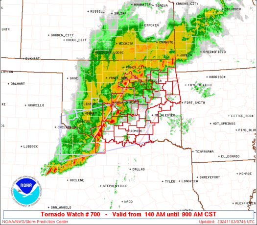
Tornado Watch Number 700
NWS Storm Prediction Center Norman OK
140 AM CST Sun Nov 3 2024
The NWS Storm Prediction Center has issued a
* Tornado Watch for portions of
Central and eastern Oklahoma
A small part of northwest Texas
* Effective this Sunday morning from 140 AM until 900 AM CST.
* Primary threats include...
A few tornadoes possible
Isolated very large hail events to 2 inches in diameter possible
Isolated damaging wind gusts to 70 mph possible
SUMMARY...Previously and potentially tornadic supercells over parts
of central and southern OK ultimately will be absorbed by a squall
line, which itself will pose a tornado and severe-gust threat as it
moves into a favorable shear/buoyancy environment this morning.
The tornado watch area is approximately along and 65 statute miles
east and west of a line from 40 miles southwest of Ardmore OK to 15
miles east northeast of Tulsa OK. For a complete depiction of the
watch see the associated watch outline update (WOUS64 KWNS WOU0).
PRECAUTIONARY/PREPAREDNESS ACTIONS...
REMEMBER...A Tornado Watch means conditions are favorable for
tornadoes and severe thunderstorms in and close to the watch
area. Persons in these areas should be on the lookout for
threatening weather conditions and listen for later statements
and possible warnings.
&&
OTHER WATCH INFORMATION...CONTINUE...WW 699...
AVIATION...Tornadoes and a few severe thunderstorms with hail
surface and aloft to 2 inches. Extreme turbulence and surface wind
gusts to 60 knots. A few cumulonimbi with maximum tops to 500. Mean
storm motion vector 24035.
...Edwards
 Note:
The Aviation Watch (SAW) product is an approximation to the watch area.
The actual watch is depicted by the shaded areas.
Note:
The Aviation Watch (SAW) product is an approximation to the watch area.
The actual watch is depicted by the shaded areas.
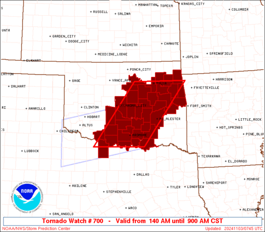
   SAW0
   WW 700 TORNADO OK TX 030740Z - 031500Z
   AXIS..65 STATUTE MILES EAST AND WEST OF LINE..
   40SW ADM/ARDMORE OK/ - 15ENE TUL/TULSA OK/
   ..AVIATION COORDS.. 55NM E/W /26SW ADM - 9ENE TUL/
   HAIL SURFACE AND ALOFT..2 INCHES. WIND GUSTS..60 KNOTS.
   MAX TOPS TO 500. MEAN STORM MOTION VECTOR 24035.

   LAT...LON 33879865 36289680 36289446 33879638

   THIS IS AN APPROXIMATION TO THE WATCH AREA.  FOR A
   COMPLETE DEPICTION OF THE WATCH SEE WOUS64 KWNS
   FOR WOU0.
Watch 700 Status Report Messages:
STATUS REPORT #2 ON WW 700

VALID 031045Z - 031140Z

SEVERE WEATHER THREAT CONTINUES RIGHT OF A LINE FROM 40 ESE SPS
TO 35 NE ADM TO 15 NW MLC TO 5 WSW MKO TO 20 ENE TUL.

..MOSIER..11/03/24

ATTN...WFO...TSA...OUN...

&&

STATUS REPORT FOR WT 700

SEVERE WEATHER THREAT CONTINUES FOR THE FOLLOWING AREAS

OKC001-005-013-019-021-029-041-061-069-085-091-095-097-101-121-
131-135-145-031140-

OK
.    OKLAHOMA COUNTIES INCLUDED ARE

ADAIR		     ATOKA		 BRYAN
CARTER		     CHEROKEE		 COAL
DELAWARE	     HASKELL		 JOHNSTON
LOVE		     MCINTOSH		 MARSHALL
MAYES		     MUSKOGEE		 PITTSBURG
ROGERS		     SEQUOYAH		 WAGONER
$$


THE WATCH STATUS MESSAGE IS FOR GUIDANCE PURPOSES ONLY.  PLEASE
REFER TO WATCH COUNTY NOTIFICATION STATEMENTS FOR OFFICIAL
INFORMATION ON COUNTIES...INDEPENDENT CITIES AND MARINE ZONES
CLEARED FROM SEVERE THUNDERSTORM AND TORNADO WATCHES.
$$

STATUS REPORT #1 ON WW 700

VALID 030900Z - 031040Z

SEVERE WEATHER THREAT CONTINUES RIGHT OF A LINE FROM 20 ESE SPS
TO 40 SE OKC TO 35 S PNC.

FOR ADDITIONAL INFORMATION SEE MESOSCALE DISCUSSION 2187

..MOSIER..11/03/24

ATTN...WFO...TSA...OUN...

&&

STATUS REPORT FOR WT 700

SEVERE WEATHER THREAT CONTINUES FOR THE FOLLOWING AREAS

OKC001-005-013-019-021-029-037-041-049-061-063-067-069-081-085-
091-095-097-099-101-107-111-117-119-121-123-125-131-133-135-143-
145-031040-

OK
.    OKLAHOMA COUNTIES INCLUDED ARE

ADAIR		     ATOKA		 BRYAN
CARTER		     CHEROKEE		 COAL
CREEK		     DELAWARE		 GARVIN
HASKELL 	     HUGHES		 JEFFERSON
JOHNSTON	     LINCOLN		 LOVE
MCINTOSH	     MARSHALL		 MAYES
MURRAY		     MUSKOGEE		 OKFUSKEE
OKMULGEE	     PAWNEE		 PAYNE
PITTSBURG	     PONTOTOC		 POTTAWATOMIE
ROGERS		     SEMINOLE		 SEQUOYAH
TULSA		     WAGONER
$$


TXC077-031040-

TX
.    TEXAS COUNTIES INCLUDED ARE

CLAY
$$


THE WATCH STATUS MESSAGE IS FOR GUIDANCE PURPOSES ONLY.  PLEASE
REFER TO WATCH COUNTY NOTIFICATION STATEMENTS FOR OFFICIAL
INFORMATION ON COUNTIES...INDEPENDENT CITIES AND MARINE ZONES
CLEARED FROM SEVERE THUNDERSTORM AND TORNADO WATCHES.
$$
Note:
Click for Complete Product Text.
Tornadoes
Probability of 2 or more tornadoes
|
Mod (50%)
|
Probability of 1 or more strong (EF2-EF5) tornadoes
|
Low (20%)
|
Wind
Probability of 10 or more severe wind events
|
Mod (30%)
|
Probability of 1 or more wind events > 65 knots
|
Low (20%)
|
Hail
Probability of 10 or more severe hail events
|
Mod (30%)
|
Probability of 1 or more hailstones > 2 inches
|
Mod (30%)
|
Combined Severe Hail/Wind
Probability of 6 or more combined severe hail/wind events
|
Mod (60%)
|
For each watch, probabilities for particular events inside the watch
(listed above in each table) are determined by the issuing forecaster.
The "Low" category contains probability values ranging from less than 2%
to 20% (EF2-EF5 tornadoes), less than 5% to 20% (all other probabilities),
"Moderate" from 30% to 60%, and "High" from 70% to greater than 95%.
High values are bolded and lighter in color to provide awareness of
an increased threat for a particular event.


 @NWSSPC


