|
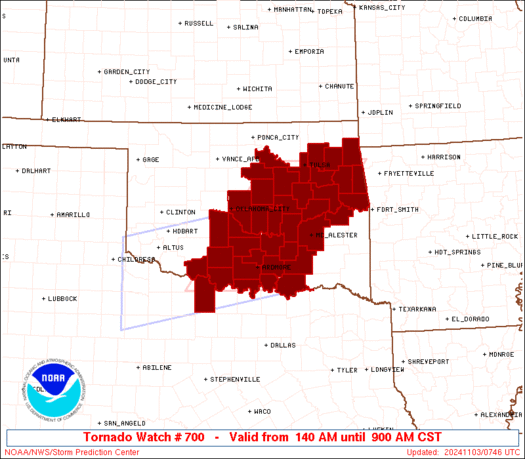
Initial List of Counties in SPC Tornado Watch 700 (WOU)
|
Back to Watch 700
|
 |
   WOUS64 KWNS 030737
   WOU0

   BULLETIN - IMMEDIATE BROADCAST REQUESTED
   TORNADO WATCH OUTLINE UPDATE FOR WT 700
   NWS STORM PREDICTION CENTER NORMAN OK
   140 AM CST SUN NOV 3 2024

   TORNADO WATCH 700 IS IN EFFECT UNTIL 900 AM CST FOR THE
    FOLLOWING LOCATIONS

   OKC001-005-013-019-021-027-029-033-037-041-049-051-061-063-067-
   069-081-085-087-091-095-097-099-101-107-109-111-117-119-121-123-
   125-131-133-135-137-143-145-031500-
   /O.NEW.KWNS.TO.A.0700.241103T0740Z-241103T1500Z/

   OK
   .    OKLAHOMA COUNTIES INCLUDED ARE

   ADAIR                ATOKA               BRYAN
   CARTER               CHEROKEE            CLEVELAND
   COAL                 COTTON              CREEK
   DELAWARE             GARVIN              GRADY
   HASKELL              HUGHES              JEFFERSON
   JOHNSTON             LINCOLN             LOVE
   MARSHALL             MAYES               MCCLAIN
   MCINTOSH             MURRAY              MUSKOGEE
   OKFUSKEE             OKLAHOMA            OKMULGEE
   PAWNEE               PAYNE               PITTSBURG
   PONTOTOC             POTTAWATOMIE        ROGERS
   SEMINOLE             SEQUOYAH            STEPHENS
   TULSA                WAGONER


   TXC077-031500-
   /O.NEW.KWNS.TO.A.0700.241103T0740Z-241103T1500Z/

   TX
   .    TEXAS COUNTIES INCLUDED ARE

   CLAY


   ATTN...WFO...TSA...OUN...
|
| Aviation Watch (SAW) for WW700 |
|---|
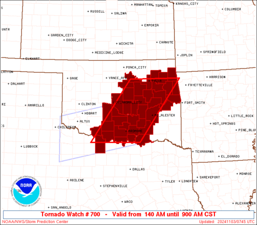 |
| Note:
The Aviation Watch (SAW) product is an approximation to the watch area.
The actual watch is depicted by the shaded areas. |
   SAW0
   WW 700 TORNADO OK TX 030740Z - 031500Z
   AXIS..65 STATUTE MILES EAST AND WEST OF LINE..
   40SW ADM/ARDMORE OK/ - 15ENE TUL/TULSA OK/
   ..AVIATION COORDS.. 55NM E/W /26SW ADM - 9ENE TUL/
   HAIL SURFACE AND ALOFT..2 INCHES. WIND GUSTS..60 KNOTS.
   MAX TOPS TO 500. MEAN STORM MOTION VECTOR 24035.

   LAT...LON 33879865 36289680 36289446 33879638

   THIS IS AN APPROXIMATION TO THE WATCH AREA.  FOR A
   COMPLETE DEPICTION OF THE WATCH SEE WOUS64 KWNS
   FOR WOU0.
|
|


 @NWSSPC
