Note:
The expiration time in the watch graphic is amended if the watch is
replaced, cancelled or extended.
Note:
Note:
The expiration time in the watch graphic is amended if the watch is
replaced, cancelled or extended.
Note: Click for
Watch Status Reports.
SEL2
URGENT - IMMEDIATE BROADCAST REQUESTED
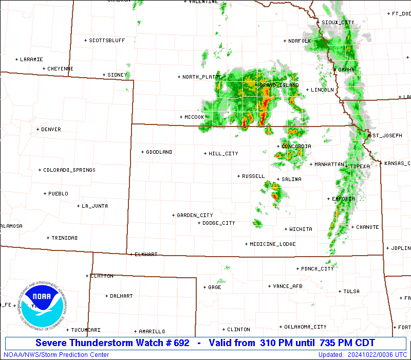
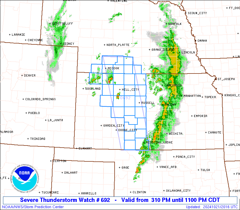
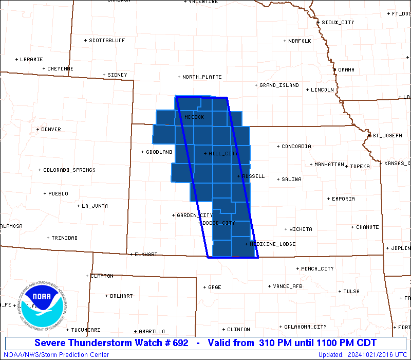
Severe Thunderstorm Watch Number 692
NWS Storm Prediction Center Norman OK
310 PM CDT Mon Oct 21 2024
The NWS Storm Prediction Center has issued a
* Severe Thunderstorm Watch for portions of
West-Central and Northern Kansas
Southern Nebraska
* Effective this Monday afternoon and evening from 310 PM until
1100 PM CDT.
* Primary threats include...
Scattered large hail events to 1.5 inches in diameter possible
Isolated damaging wind gusts to 70 mph possible
A tornado or two possible
SUMMARY...Strong to severe storms are expected to redevelop across
the region through late afternoon, initially across
northwest/west-central Kansas.
The severe thunderstorm watch area is approximately along and 40
statute miles east and west of a line from 45 miles northeast of
Mccook NE to 30 miles southwest of Medicine Lodge KS. For a complete
depiction of the watch see the associated watch outline update
(WOUS64 KWNS WOU2).
PRECAUTIONARY/PREPAREDNESS ACTIONS...
REMEMBER...A Severe Thunderstorm Watch means conditions are
favorable for severe thunderstorms in and close to the watch area.
Persons in these areas should be on the lookout for threatening
weather conditions and listen for later statements and possible
warnings. Severe thunderstorms can and occasionally do produce
tornadoes.
&&
AVIATION...A few severe thunderstorms with hail surface and aloft to
1.5 inches. Extreme turbulence and surface wind gusts to 60 knots. A
few cumulonimbi with maximum tops to 450. Mean storm motion vector
22025.
...Guyer

   SEL2

   URGENT - IMMEDIATE BROADCAST REQUESTED
   Severe Thunderstorm Watch Number 692
   NWS Storm Prediction Center Norman OK
   310 PM CDT Mon Oct 21 2024

   The NWS Storm Prediction Center has issued a

   * Severe Thunderstorm Watch for portions of
     West-Central and Northern Kansas
     Southern Nebraska

   * Effective this Monday afternoon and evening from 310 PM until
     1100 PM CDT.

   * Primary threats include...
     Scattered large hail events to 1.5 inches in diameter possible
     Isolated damaging wind gusts to 70 mph possible
     A tornado or two possible

   SUMMARY...Strong to severe storms are expected to redevelop across
   the region through late afternoon, initially across
   northwest/west-central Kansas.

   The severe thunderstorm watch area is approximately along and 40
   statute miles east and west of a line from 45 miles northeast of
   Mccook NE to 30 miles southwest of Medicine Lodge KS. For a complete
   depiction of the watch see the associated watch outline update
   (WOUS64 KWNS WOU2).

   PRECAUTIONARY/PREPAREDNESS ACTIONS...

   REMEMBER...A Severe Thunderstorm Watch means conditions are
   favorable for severe thunderstorms in and close to the watch area.
   Persons in these areas should be on the lookout for threatening
   weather conditions and listen for later statements and possible
   warnings. Severe thunderstorms can and occasionally do produce
   tornadoes.

   &&

   AVIATION...A few severe thunderstorms with hail surface and aloft to
   1.5 inches. Extreme turbulence and surface wind gusts to 60 knots. A
   few cumulonimbi with maximum tops to 450. Mean storm motion vector
   22025.

   ...Guyer
 Note:
The Aviation Watch (SAW) product is an approximation to the watch area.
The actual watch is depicted by the shaded areas.
Note:
The Aviation Watch (SAW) product is an approximation to the watch area.
The actual watch is depicted by the shaded areas.
   SAW2
   WW 692 SEVERE TSTM KS NE 212010Z - 220400Z
   AXIS..40 STATUTE MILES EAST AND WEST OF LINE..
   45NE MCK/MCCOOK NE/ - 30SW P28/MEDICINE LODGE KS/
   ..AVIATION COORDS.. 35NM E/W /39NE MCK - 59NE MMB/
   HAIL SURFACE AND ALOFT..1.5 INCHES. WIND GUSTS..60 KNOTS.
   MAX TOPS TO 450. MEAN STORM MOTION VECTOR 22025.

   LAT...LON 40669921 36989824 36989969 40660074

   THIS IS AN APPROXIMATION TO THE WATCH AREA.  FOR A
   COMPLETE DEPICTION OF THE WATCH SEE WOUS64 KWNS
   FOR WOU2.
Watch 692 Status Report Messages:
STATUS REPORT #3 ON WW 692
VALID 220010Z - 220140Z
SEVERE WEATHER THREAT CONTINUES RIGHT OF A LINE FROM 40 S DDC TO
40 SSW RSL TO 30 WNW RSL TO 40 NNE HLC TO 15 S LBF.
..DEAN..10/22/24
ATTN...WFO...DDC...ICT...GLD...GID...LBF...
&&
STATUS REPORT FOR WS 692
SEVERE WEATHER THREAT CONTINUES FOR THE FOLLOWING AREAS
KSC007-009-033-047-051-097-141-145-147-151-163-165-167-183-185-
220140-
KS
. KANSAS COUNTIES INCLUDED ARE
BARBER BARTON COMANCHE
EDWARDS ELLIS KIOWA
OSBORNE PAWNEE PHILLIPS
PRATT ROOKS RUSH
RUSSELL SMITH STAFFORD
$$
NEC061-065-073-083-137-220140-
NE
. NEBRASKA COUNTIES INCLUDED ARE
FRANKLIN FURNAS GOSPER
HARLAN PHELPS
$$
THE WATCH STATUS MESSAGE IS FOR GUIDANCE PURPOSES ONLY. PLEASE
REFER TO WATCH COUNTY NOTIFICATION STATEMENTS FOR OFFICIAL
INFORMATION ON COUNTIES...INDEPENDENT CITIES AND MARINE ZONES
CLEARED FROM SEVERE THUNDERSTORM AND TORNADO WATCHES.
$$
STATUS REPORT #2 ON WW 692
VALID 212310Z - 220040Z
SEVERE WEATHER THREAT CONTINUES RIGHT OF A LINE FROM 10 N DDC TO
50 SW RSL TO 40 SSE HLC TO 5 ESE HLC TO 15 WNW HLC TO 50 E GLD.
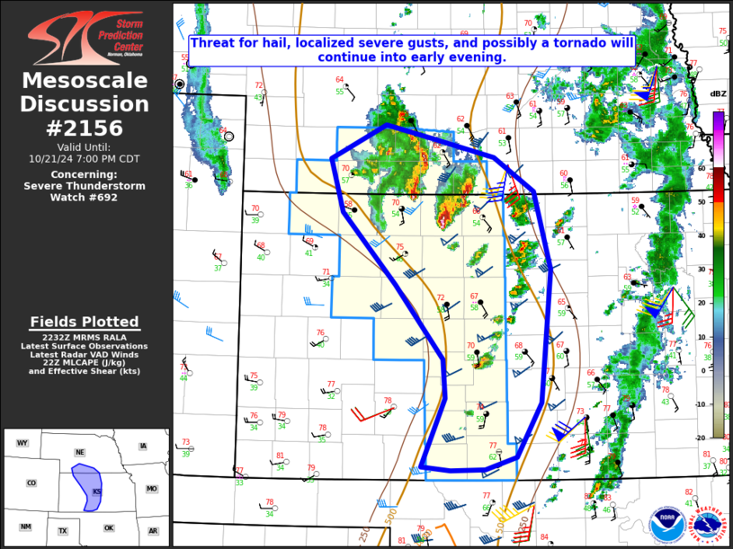
FOR ADDITIONAL INFORMATION SEE MESOSCALE DISCUSSION 2156
..DEAN..10/21/24
ATTN...WFO...DDC...ICT...GLD...GID...LBF...
&&
STATUS REPORT FOR WS 692
SEVERE WEATHER THREAT CONTINUES FOR THE FOLLOWING AREAS
KSC007-009-033-039-047-051-065-097-137-141-145-147-151-153-163-
165-167-179-183-185-220040-
KS
. KANSAS COUNTIES INCLUDED ARE
BARBER BARTON COMANCHE
DECATUR EDWARDS ELLIS
GRAHAM KIOWA NORTON
OSBORNE PAWNEE PHILLIPS
PRATT RAWLINS ROOKS
RUSH RUSSELL SHERIDAN
SMITH STAFFORD
$$
NEC061-063-065-073-083-087-137-145-220040-
NE
. NEBRASKA COUNTIES INCLUDED ARE
FRANKLIN FRONTIER FURNAS
GOSPER HARLAN HITCHCOCK
PHELPS RED WILLOW
$$
THE WATCH STATUS MESSAGE IS FOR GUIDANCE PURPOSES ONLY. PLEASE
REFER TO WATCH COUNTY NOTIFICATION STATEMENTS FOR OFFICIAL
INFORMATION ON COUNTIES...INDEPENDENT CITIES AND MARINE ZONES
CLEARED FROM SEVERE THUNDERSTORM AND TORNADO WATCHES.
$$
STATUS REPORT #1 ON WW 692
VALID 212120Z - 212240Z
THE SEVERE WEATHER THREAT CONTINUES ACROSS THE ENTIRE WATCH AREA.
..DEAN..10/21/24
ATTN...WFO...DDC...ICT...GLD...GID...LBF...
&&
STATUS REPORT FOR WS 692
SEVERE WEATHER THREAT CONTINUES FOR THE FOLLOWING AREAS
KSC007-009-033-039-047-051-063-065-097-135-137-141-145-147-151-
153-163-165-167-179-183-185-195-212240-
KS
. KANSAS COUNTIES INCLUDED ARE
BARBER BARTON COMANCHE
DECATUR EDWARDS ELLIS
GOVE GRAHAM KIOWA
NESS NORTON OSBORNE
PAWNEE PHILLIPS PRATT
RAWLINS ROOKS RUSH
RUSSELL SHERIDAN SMITH
STAFFORD TREGO
$$
NEC061-063-065-073-083-087-137-145-212240-
NE
. NEBRASKA COUNTIES INCLUDED ARE
FRANKLIN FRONTIER FURNAS
GOSPER HARLAN HITCHCOCK
PHELPS RED WILLOW
$$
THE WATCH STATUS MESSAGE IS FOR GUIDANCE PURPOSES ONLY. PLEASE
REFER TO WATCH COUNTY NOTIFICATION STATEMENTS FOR OFFICIAL
INFORMATION ON COUNTIES...INDEPENDENT CITIES AND MARINE ZONES
CLEARED FROM SEVERE THUNDERSTORM AND TORNADO WATCHES.
$$
Note:
Click for Complete Product Text.
Tornadoes
Probability of 2 or more tornadoes
|
Low (20%)
|
Probability of 1 or more strong (EF2-EF5) tornadoes
|
Low (5%)
|
Wind
Probability of 10 or more severe wind events
|
Low (20%)
|
Probability of 1 or more wind events > 65 knots
|
Low (10%)
|
Hail
Probability of 10 or more severe hail events
|
Mod (40%)
|
Probability of 1 or more hailstones > 2 inches
|
Low (10%)
|
Combined Severe Hail/Wind
Probability of 6 or more combined severe hail/wind events
|
Mod (60%)
|
For each watch, probabilities for particular events inside the watch
(listed above in each table) are determined by the issuing forecaster.
The "Low" category contains probability values ranging from less than 2%
to 20% (EF2-EF5 tornadoes), less than 5% to 20% (all other probabilities),
"Moderate" from 30% to 60%, and "High" from 70% to greater than 95%.
High values are bolded and lighter in color to provide awareness of
an increased threat for a particular event.


 @NWSSPC