 Note:
The expiration time in the watch graphic is amended if the watch is
replaced, cancelled or extended.
Note:
Note:
The expiration time in the watch graphic is amended if the watch is
replaced, cancelled or extended.
Note: Click for
Watch Status Reports.
SEL0
URGENT - IMMEDIATE BROADCAST REQUESTED
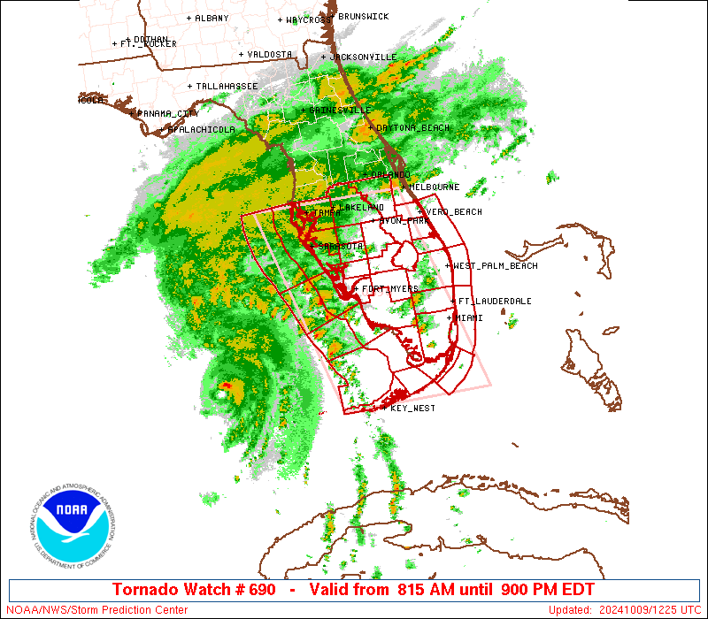
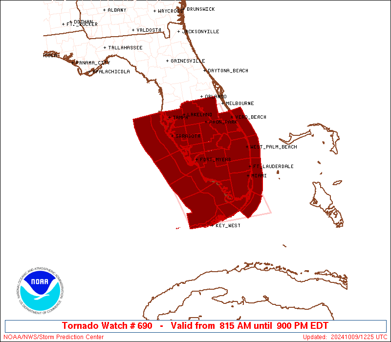
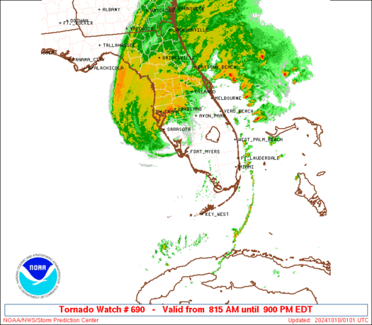
Tornado Watch Number 690
NWS Storm Prediction Center Norman OK
815 AM EDT Wed Oct 9 2024
The NWS Storm Prediction Center has issued a
* Tornado Watch for portions of
Central and South Florida
Coastal Waters
* Effective this Wednesday morning and evening from 815 AM until
900 PM EDT.
* Primary threats include...
Several tornadoes likely
Isolated damaging wind gusts to 70 mph possible
SUMMARY...Supercells in the outer rain bands of Hurricane Milton
will pose a threat for several tornadoes today across the central
and southern Florida Peninsula. The forecast maximum wind gusts and
mean cell motion apply to severe thunderstorms outside the eyewall.
The tornado watch area is approximately along and 85 statute miles
east and west of a line from 35 miles east northeast of Saint
Petersburg FL to 10 miles south southwest of Marathon FL. For a
complete depiction of the watch see the associated watch outline
update (WOUS64 KWNS WOU0).
PRECAUTIONARY/PREPAREDNESS ACTIONS...
REMEMBER...A Tornado Watch means conditions are favorable for
tornadoes and severe thunderstorms in and close to the watch
area. Persons in these areas should be on the lookout for
threatening weather conditions and listen for later statements
and possible warnings.
&&
AVIATION...Tornadoes and a few severe thunderstorms with hail
surface and aloft to 0.5 inches. Extreme turbulence and surface wind
gusts to 60 knots. A few cumulonimbi with maximum tops to 500. Mean
storm motion vector 17040.
...Gleason
 Note:
The Aviation Watch (SAW) product is an approximation to the watch area.
The actual watch is depicted by the shaded areas.
Note:
The Aviation Watch (SAW) product is an approximation to the watch area.
The actual watch is depicted by the shaded areas.
   SAW0
   WW 690 TORNADO FL CW 091215Z - 100100Z
   AXIS..85 STATUTE MILES EAST AND WEST OF LINE..
   35ENE PIE/SAINT PETERSBURG FL/ - 10SSW MTH/MARATHON FL/
   ..AVIATION COORDS.. 75NM E/W /31ENE PIE - 38E EYW/
   HAIL SURFACE AND ALOFT..0.5 INCH. WIND GUSTS..60 KNOTS.
   MAX TOPS TO 500. MEAN STORM MOTION VECTOR 17040.

   LAT...LON 28118075 24597976 24598246 28118354

   THIS IS AN APPROXIMATION TO THE WATCH AREA.  FOR A
   COMPLETE DEPICTION OF THE WATCH SEE WOUS64 KWNS
   FOR WOU0.
Watch 690 Status Report Messages:
STATUS REPORT #6 ON WW 690
VALID 100045Z - 100140Z
SEVERE WEATHER THREAT CONTINUES RIGHT OF A LINE FROM 40 NW PIE TO
15 W PIE TO 15 S SRQ TO 25 ESE SRQ TO 35 WSW AGR TO 15 WSW AGR TO
40 SE AGR TO 30 NW PBI TO 40 NE PBI.
..BROYLES..10/10/24
ATTN...WFO...MFL...TBW...MLB...KEY...
&&
STATUS REPORT FOR WT 690
SEVERE WEATHER THREAT CONTINUES FOR THE FOLLOWING AREAS
FLC009-053-057-061-069-081-085-093-095-097-101-103-105-111-115-
117-119-127-100140-
FL
. FLORIDA COUNTIES INCLUDED ARE
BREVARD HERNANDO HILLSBOROUGH
INDIAN RIVER LAKE MANATEE
MARTIN OKEECHOBEE ORANGE
OSCEOLA PASCO PINELLAS
POLK ST. LUCIE SARASOTA
SEMINOLE SUMTER VOLUSIA
$$
AMZ550-552-555-GMZ830-100140-
CW
. ADJACENT COASTAL WATERS INCLUDED ARE
FLAGLER BEACH TO VOLUSIA-BREVARD COUNTY LINE 0-20 NM
VOLUSIA-BREVARD COUNTY LINE TO SEBASTIAN INLET 0-20 NM
SEBASTIAN INLET TO JUPITER INLET 0-20 NM
TAMPA BAY WATERS
$$
THE WATCH STATUS MESSAGE IS FOR GUIDANCE PURPOSES ONLY. PLEASE
REFER TO WATCH COUNTY NOTIFICATION STATEMENTS FOR OFFICIAL
INFORMATION ON COUNTIES...INDEPENDENT CITIES AND MARINE ZONES
CLEARED FROM SEVERE THUNDERSTORM AND TORNADO WATCHES.
$$
STATUS REPORT #5 ON WW 690
VALID 092310Z - 100040Z
SEVERE WEATHER THREAT CONTINUES RIGHT OF A LINE FROM 50 E PBI TO
55 SSE AGR TO 35 S SRQ TO 75 SW SRQ.
..BROYLES..10/09/24
ATTN...WFO...MFL...TBW...MLB...KEY...
&&
STATUS REPORT FOR WT 690
SEVERE WEATHER THREAT CONTINUES FOR THE FOLLOWING AREAS
FLC009-053-057-061-069-081-085-093-095-097-101-103-105-111-115-
117-119-127-100040-
FL
. FLORIDA COUNTIES INCLUDED ARE
BREVARD HERNANDO HILLSBOROUGH
INDIAN RIVER LAKE MANATEE
MARTIN OKEECHOBEE ORANGE
OSCEOLA PASCO PINELLAS
POLK ST. LUCIE SARASOTA
SEMINOLE SUMTER VOLUSIA
$$
AMZ550-552-555-GMZ830-853-873-100040-
CW
. ADJACENT COASTAL WATERS INCLUDED ARE
FLAGLER BEACH TO VOLUSIA-BREVARD COUNTY LINE 0-20 NM
VOLUSIA-BREVARD COUNTY LINE TO SEBASTIAN INLET 0-20 NM
SEBASTIAN INLET TO JUPITER INLET 0-20 NM
TAMPA BAY WATERS
COASTAL WATERS FROM ENGLEWOOD TO TARPON SPRINGS FL OUT 20 NM
WATERS FROM ENGLEWOOD TO TARPON SPRINGS FL OUT 20 TO 60 NM
$$
THE WATCH STATUS MESSAGE IS FOR GUIDANCE PURPOSES ONLY. PLEASE
REFER TO WATCH COUNTY NOTIFICATION STATEMENTS FOR OFFICIAL
INFORMATION ON COUNTIES...INDEPENDENT CITIES AND MARINE ZONES
CLEARED FROM SEVERE THUNDERSTORM AND TORNADO WATCHES.
$$
STATUS REPORT #4 ON WW 690
VALID 092300Z - 100040Z
SEVERE WEATHER THREAT CONTINUES RIGHT OF A LINE FROM 90 WSW APF
TO 40 SSW MIA TO 15 SE MIA TO 25 WNW PBI TO 35 SSE AGR TO 30 SSE
SRQ TO 50 WSW SRQ.
..BROYLES..10/09/24
ATTN...WFO...MFL...TBW...MLB...KEY...
&&
STATUS REPORT FOR WT 690
SEVERE WEATHER THREAT CONTINUES FOR THE FOLLOWING AREAS
FLC009-053-057-061-069-081-085-093-095-097-101-103-105-111-115-
117-119-127-100040-
FL
. FLORIDA COUNTIES INCLUDED ARE
BREVARD HERNANDO HILLSBOROUGH
INDIAN RIVER LAKE MANATEE
MARTIN OKEECHOBEE ORANGE
OSCEOLA PASCO PINELLAS
POLK ST. LUCIE SARASOTA
SEMINOLE SUMTER VOLUSIA
$$
AMZ550-552-555-GMZ031-032-033-035-042-052-830-853-873-100040-
CW
. ADJACENT COASTAL WATERS INCLUDED ARE
FLAGLER BEACH TO VOLUSIA-BREVARD COUNTY LINE 0-20 NM
VOLUSIA-BREVARD COUNTY LINE TO SEBASTIAN INLET 0-20 NM
SEBASTIAN INLET TO JUPITER INLET 0-20 NM
FLORIDA BAY INCLUDING BARNES SOUND BLACKWATER SOUND AND
BUTTONWOOD SOUND
BAYSIDE AND GULF SIDE FROM CRAIG KEY TO WEST END OF SEVEN MILE
BRIDGE
GULF WATERS FROM EAST CAPE SABLE TO CHOKOLOSKEE 20 TO 60 NM OUT
AND BEYOND 5 FATHOMS
GULF OF MEXICO FROM WEST END OF SEVEN MILE BRIDGE TO HALFMOON
SHOAL OUT TO 5 FATHOMS
HAWK CHANNEL FROM OCEAN REEF TO CRAIG KEY OUT TO THE REEF
STRAITS OF FLORIDA FROM OCEAN REEF TO CRAIG KEY OUT 20 NM
TAMPA BAY WATERS
COASTAL WATERS FROM ENGLEWOOD TO TARPON SPRINGS FL OUT 20 NM
WATERS FROM ENGLEWOOD TO TARPON SPRINGS FL OUT 20 TO 60 NM
$$
THE WATCH STATUS MESSAGE IS FOR GUIDANCE PURPOSES ONLY. PLEASE
REFER TO WATCH COUNTY NOTIFICATION STATEMENTS FOR OFFICIAL
INFORMATION ON COUNTIES...INDEPENDENT CITIES AND MARINE ZONES
CLEARED FROM SEVERE THUNDERSTORM AND TORNADO WATCHES.
$$
STATUS REPORT #3 ON WW 690
VALID 092145Z - 092240Z
SEVERE WEATHER THREAT CONTINUES RIGHT OF A LINE FROM 70 NW EYW TO
5 NNE APF TO 15 E FMY TO 25 NNE FMY TO 35 NNW FMY TO 35 SW SRQ TO
75 SW SRQ.
..BROYLES..10/09/24
ATTN...WFO...MFL...TBW...MLB...KEY...
&&
STATUS REPORT FOR WT 690
SEVERE WEATHER THREAT CONTINUES FOR THE FOLLOWING AREAS
FLC009-011-021-043-049-051-053-055-057-061-069-081-085-086-087-
093-095-097-099-101-103-105-111-115-117-119-127-092240-
FL
. FLORIDA COUNTIES INCLUDED ARE
BREVARD BROWARD COLLIER
GLADES HARDEE HENDRY
HERNANDO HIGHLANDS HILLSBOROUGH
INDIAN RIVER LAKE MANATEE
MARTIN MIAMI-DADE MONROE
OKEECHOBEE ORANGE OSCEOLA
PALM BEACH PASCO PINELLAS
POLK ST. LUCIE SARASOTA
SEMINOLE SUMTER VOLUSIA
$$
AMZ550-552-555-610-630-650-651-GMZ031-032-033-035-042-052-656-657-
830-853-873-092240-
CW
. ADJACENT COASTAL WATERS INCLUDED ARE
FLAGLER BEACH TO VOLUSIA-BREVARD COUNTY LINE 0-20 NM
VOLUSIA-BREVARD COUNTY LINE TO SEBASTIAN INLET 0-20 NM
SEBASTIAN INLET TO JUPITER INLET 0-20 NM
LAKE OKEECHOBEE
BISCAYNE BAY
COASTAL WATERS FROM JUPITER INLET TO DEERFIELD BEACH FL OUT 20 NM
COASTAL WATERS FROM DEERFIELD BEACH TO OCEAN REEF FL OUT 20 NM
FLORIDA BAY INCLUDING BARNES SOUND BLACKWATER SOUND AND
BUTTONWOOD SOUND
BAYSIDE AND GULF SIDE FROM CRAIG KEY TO WEST END OF SEVEN MILE
BRIDGE
GULF WATERS FROM EAST CAPE SABLE TO CHOKOLOSKEE 20 TO 60 NM OUT
AND BEYOND 5 FATHOMS
GULF OF MEXICO FROM WEST END OF SEVEN MILE BRIDGE TO HALFMOON
SHOAL OUT TO 5 FATHOMS
HAWK CHANNEL FROM OCEAN REEF TO CRAIG KEY OUT TO THE REEF
STRAITS OF FLORIDA FROM OCEAN REEF TO CRAIG KEY OUT 20 NM
COASTAL WATERS FROM CHOKOLOSKEE TO BONITA BEACH FL OUT 20 NM
COASTAL WATERS FROM EAST CAPE SABLE TO CHOKOLOSKEE FL OUT 20 NM
TAMPA BAY WATERS
COASTAL WATERS FROM ENGLEWOOD TO TARPON SPRINGS FL OUT 20 NM
WATERS FROM ENGLEWOOD TO TARPON SPRINGS FL OUT 20 TO 60 NM
$$
THE WATCH STATUS MESSAGE IS FOR GUIDANCE PURPOSES ONLY. PLEASE
REFER TO WATCH COUNTY NOTIFICATION STATEMENTS FOR OFFICIAL
INFORMATION ON COUNTIES...INDEPENDENT CITIES AND MARINE ZONES
CLEARED FROM SEVERE THUNDERSTORM AND TORNADO WATCHES.
$$
STATUS REPORT #2 ON WW 690
VALID 091730Z - 091840Z
THE SEVERE WEATHER THREAT CONTINUES ACROSS THE ENTIRE WATCH AREA.
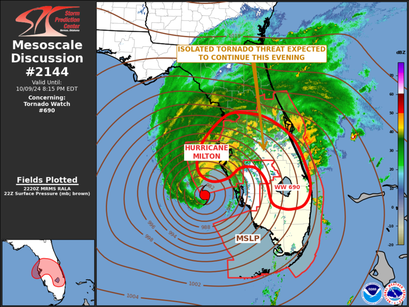
FOR ADDITIONAL INFORMATION SEE MESOSCALE DISCUSSION 2140
..MOORE..10/09/24
ATTN...WFO...MFL...TBW...MLB...KEY...
&&
STATUS REPORT FOR WT 690
SEVERE WEATHER THREAT CONTINUES FOR THE FOLLOWING AREAS
FLC011-015-021-027-043-049-051-055-057-061-071-081-085-086-087-
093-097-099-103-105-111-115-091840-
FL
. FLORIDA COUNTIES INCLUDED ARE
BROWARD CHARLOTTE COLLIER
DESOTO GLADES HARDEE
HENDRY HIGHLANDS HILLSBOROUGH
INDIAN RIVER LEE MANATEE
MARTIN MIAMI-DADE MONROE
OKEECHOBEE OSCEOLA PALM BEACH
PINELLAS POLK ST. LUCIE
SARASOTA
$$
AMZ555-610-630-650-651-GMZ031-032-033-035-042-052-656-657-676-830-
836-853-856-873-876-091840-
CW
. ADJACENT COASTAL WATERS INCLUDED ARE
SEBASTIAN INLET TO JUPITER INLET 0-20 NM
LAKE OKEECHOBEE
BISCAYNE BAY
COASTAL WATERS FROM JUPITER INLET TO DEERFIELD BEACH FL OUT 20 NM
COASTAL WATERS FROM DEERFIELD BEACH TO OCEAN REEF FL OUT 20 NM
FLORIDA BAY INCLUDING BARNES SOUND BLACKWATER SOUND AND
BUTTONWOOD SOUND
BAYSIDE AND GULF SIDE FROM CRAIG KEY TO WEST END OF SEVEN MILE
BRIDGE
GULF WATERS FROM EAST CAPE SABLE TO CHOKOLOSKEE 20 TO 60 NM OUT
AND BEYOND 5 FATHOMS
GULF OF MEXICO FROM WEST END OF SEVEN MILE BRIDGE TO HALFMOON
SHOAL OUT TO 5 FATHOMS
HAWK CHANNEL FROM OCEAN REEF TO CRAIG KEY OUT TO THE REEF
STRAITS OF FLORIDA FROM OCEAN REEF TO CRAIG KEY OUT 20 NM
COASTAL WATERS FROM CHOKOLOSKEE TO BONITA BEACH FL OUT 20 NM
COASTAL WATERS FROM EAST CAPE SABLE TO CHOKOLOSKEE FL OUT 20 NM
WATERS FROM CHOKOLOSKEE TO BONITA BEACH FL FROM 20 TO 60 NM
TAMPA BAY WATERS
CHARLOTTE HARBOR AND PINE ISLAND SOUND
COASTAL WATERS FROM ENGLEWOOD TO TARPON SPRINGS FL OUT 20 NM
COASTAL WATERS FROM BONITA BEACH TO ENGLEWOOD FL OUT 20 NM
WATERS FROM ENGLEWOOD TO TARPON SPRINGS FL OUT 20 TO 60 NM
WATERS FROM BONITA BEACH TO ENGLEWOOD FL OUT 20 TO 60 NM
$$
THE WATCH STATUS MESSAGE IS FOR GUIDANCE PURPOSES ONLY. PLEASE
REFER TO WATCH COUNTY NOTIFICATION STATEMENTS FOR OFFICIAL
INFORMATION ON COUNTIES...INDEPENDENT CITIES AND MARINE ZONES
CLEARED FROM SEVERE THUNDERSTORM AND TORNADO WATCHES.
$$
STATUS REPORT #1 ON WW 690
VALID 091535Z - 091640Z
THE SEVERE WEATHER THREAT CONTINUES ACROSS THE ENTIRE WATCH AREA.
FOR ADDITIONAL INFORMATION SEE MESOSCALE DISCUSSION 2137
..MOORE..10/09/24
ATTN...WFO...MFL...TBW...MLB...KEY...
&&
STATUS REPORT FOR WT 690
SEVERE WEATHER THREAT CONTINUES FOR THE FOLLOWING AREAS
FLC011-015-021-027-043-049-051-055-057-061-071-081-085-086-087-
093-097-099-103-105-111-115-091640-
FL
. FLORIDA COUNTIES INCLUDED ARE
BROWARD CHARLOTTE COLLIER
DESOTO GLADES HARDEE
HENDRY HIGHLANDS HILLSBOROUGH
INDIAN RIVER LEE MANATEE
MARTIN MIAMI-DADE MONROE
OKEECHOBEE OSCEOLA PALM BEACH
PINELLAS POLK ST. LUCIE
SARASOTA
$$
AMZ555-610-630-650-651-GMZ031-032-033-035-042-052-656-657-676-830-
836-853-856-873-876-091640-
CW
. ADJACENT COASTAL WATERS INCLUDED ARE
SEBASTIAN INLET TO JUPITER INLET 0-20 NM
LAKE OKEECHOBEE
BISCAYNE BAY
COASTAL WATERS FROM JUPITER INLET TO DEERFIELD BEACH FL OUT 20 NM
COASTAL WATERS FROM DEERFIELD BEACH TO OCEAN REEF FL OUT 20 NM
FLORIDA BAY INCLUDING BARNES SOUND BLACKWATER SOUND AND
BUTTONWOOD SOUND
BAYSIDE AND GULF SIDE FROM CRAIG KEY TO WEST END OF SEVEN MILE
BRIDGE
GULF WATERS FROM EAST CAPE SABLE TO CHOKOLOSKEE 20 TO 60 NM OUT
AND BEYOND 5 FATHOMS
GULF OF MEXICO FROM WEST END OF SEVEN MILE BRIDGE TO HALFMOON
SHOAL OUT TO 5 FATHOMS
HAWK CHANNEL FROM OCEAN REEF TO CRAIG KEY OUT TO THE REEF
STRAITS OF FLORIDA FROM OCEAN REEF TO CRAIG KEY OUT 20 NM
COASTAL WATERS FROM CHOKOLOSKEE TO BONITA BEACH FL OUT 20 NM
COASTAL WATERS FROM EAST CAPE SABLE TO CHOKOLOSKEE FL OUT 20 NM
WATERS FROM CHOKOLOSKEE TO BONITA BEACH FL FROM 20 TO 60 NM
TAMPA BAY WATERS
CHARLOTTE HARBOR AND PINE ISLAND SOUND
COASTAL WATERS FROM ENGLEWOOD TO TARPON SPRINGS FL OUT 20 NM
COASTAL WATERS FROM BONITA BEACH TO ENGLEWOOD FL OUT 20 NM
WATERS FROM ENGLEWOOD TO TARPON SPRINGS FL OUT 20 TO 60 NM
WATERS FROM BONITA BEACH TO ENGLEWOOD FL OUT 20 TO 60 NM
$$
THE WATCH STATUS MESSAGE IS FOR GUIDANCE PURPOSES ONLY. PLEASE
REFER TO WATCH COUNTY NOTIFICATION STATEMENTS FOR OFFICIAL
INFORMATION ON COUNTIES...INDEPENDENT CITIES AND MARINE ZONES
CLEARED FROM SEVERE THUNDERSTORM AND TORNADO WATCHES.
$$
Note:
Click for Complete Product Text.
Tornadoes
Probability of 2 or more tornadoes
|
High (80%)
|
Probability of 1 or more strong (EF2-EF5) tornadoes
|
Low (20%)
|
Wind
Probability of 10 or more severe wind events
|
Low (20%)
|
Probability of 1 or more wind events > 65 knots
|
Low (10%)
|
Hail
Probability of 10 or more severe hail events
|
Low (<5%)
|
Probability of 1 or more hailstones > 2 inches
|
Low (<5%)
|
Combined Severe Hail/Wind
Probability of 6 or more combined severe hail/wind events
|
Mod (30%)
|
For each watch, probabilities for particular events inside the watch
(listed above in each table) are determined by the issuing forecaster.
The "Low" category contains probability values ranging from less than 2%
to 20% (EF2-EF5 tornadoes), less than 5% to 20% (all other probabilities),
"Moderate" from 30% to 60%, and "High" from 70% to greater than 95%.
High values are bolded and lighter in color to provide awareness of
an increased threat for a particular event.


 @NWSSPC