 Note:
The expiration time in the watch graphic is amended if the watch is
replaced, cancelled or extended.
Note:
Note:
The expiration time in the watch graphic is amended if the watch is
replaced, cancelled or extended.
Note: Click for
Watch Status Reports.
SEL9
URGENT - IMMEDIATE BROADCAST REQUESTED
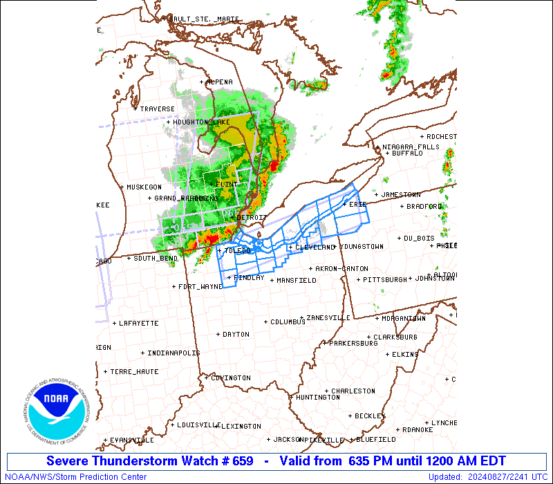
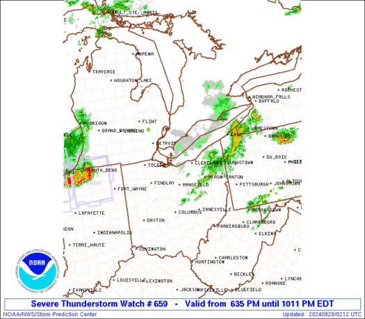
Severe Thunderstorm Watch Number 659
NWS Storm Prediction Center Norman OK
635 PM EDT Tue Aug 27 2024
The NWS Storm Prediction Center has issued a
* Severe Thunderstorm Watch for portions of
Northern Ohio
Far Northwest Pennsylvania
Lake Erie
* Effective this Tuesday night from 635 PM until Midnight EDT.
* Primary threats include...
Scattered damaging wind gusts to 70 mph possible
Isolated large hail events to 1 inch in diameter possible
SUMMARY...A line of thunderstorms should continue to pose some
threat for severe/damaging winds up to 60-70 mph as it moves
east-southeastward this evening across parts of northern Ohio and
eventually far northwest Pennsylvania.
The severe thunderstorm watch area is approximately along and 25
statute miles north and south of a line from 15 miles south of
Toledo OH to 20 miles east southeast of Erie PA. For a complete
depiction of the watch see the associated watch outline update
(WOUS64 KWNS WOU9).
PRECAUTIONARY/PREPAREDNESS ACTIONS...
REMEMBER...A Severe Thunderstorm Watch means conditions are
favorable for severe thunderstorms in and close to the watch area.
Persons in these areas should be on the lookout for threatening
weather conditions and listen for later statements and possible
warnings. Severe thunderstorms can and occasionally do produce
tornadoes.
&&
OTHER WATCH INFORMATION...CONTINUE...WW 656...WW 657...WW 658...
AVIATION...A few severe thunderstorms with hail surface and aloft to
1 inch. Extreme turbulence and surface wind gusts to 60 knots. A few
cumulonimbi with maximum tops to 500. Mean storm motion vector
30035.
...Gleason
 Note:
The Aviation Watch (SAW) product is an approximation to the watch area.
The actual watch is depicted by the shaded areas.
Note:
The Aviation Watch (SAW) product is an approximation to the watch area.
The actual watch is depicted by the shaded areas.
SAW9
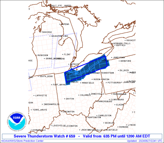
WW 659 SEVERE TSTM OH PA LE 272235Z - 280400Z
AXIS..25 STATUTE MILES NORTH AND SOUTH OF LINE..
15S TOL/TOLEDO OH/ - 20ESE ERI/ERIE PA/
..AVIATION COORDS.. 20NM N/S /54SSW DXO - 22E ERI/
HAIL SURFACE AND ALOFT..1 INCH. WIND GUSTS..60 KNOTS.
MAX TOPS TO 500. MEAN STORM MOTION VECTOR 30035.
LAT...LON 41728380 42337982 41617982 41008380
THIS IS AN APPROXIMATION TO THE WATCH AREA. FOR A
COMPLETE DEPICTION OF THE WATCH SEE WOUS64 KWNS
FOR WOU9.
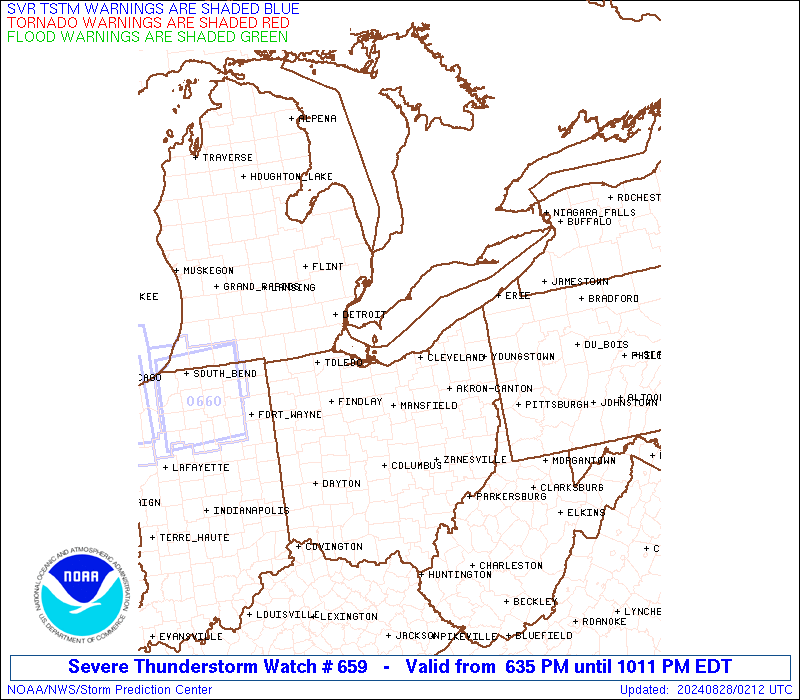
Watch 659 Status Report Messages:
STATUS REPORT #1 ON WW 659
VALID 280050Z - 280140Z
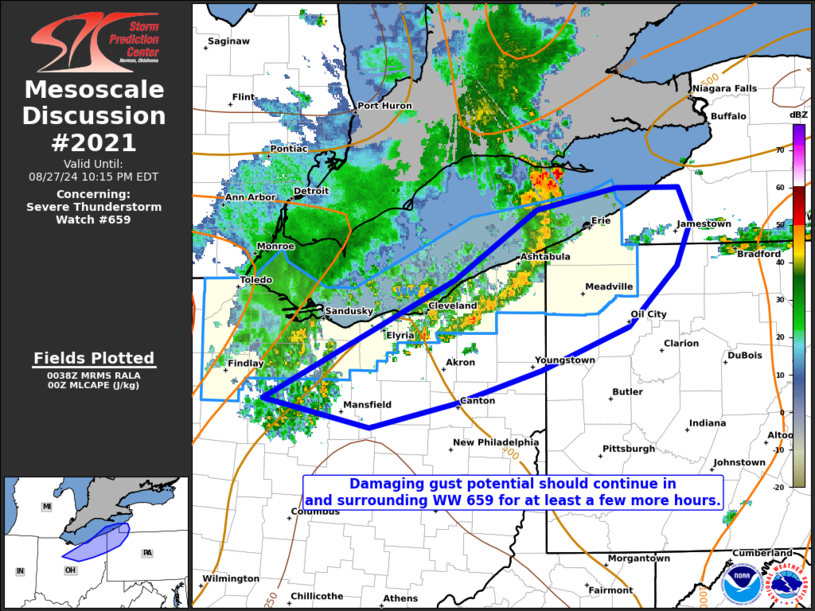
SEVERE WEATHER THREAT CONTINUES RIGHT OF A LINE FROM 20 SW CLE TO
35 N YNG TO 30 NW ERI.
FOR ADDITIONAL INFORMATION SEE MESOSCALE DISCUSSION 2021
..SQUITIERI..08/28/24
ATTN...WFO...CLE...
&&
STATUS REPORT FOR WS 659
SEVERE WEATHER THREAT CONTINUES FOR THE FOLLOWING AREAS
OHC007-055-280140-
OH
. OHIO COUNTIES INCLUDED ARE
ASHTABULA GEAUGA
$$
PAC039-049-280140-
PA
. PENNSYLVANIA COUNTIES INCLUDED ARE
CRAWFORD ERIE
$$
LEZ149-169-280140-
CW
. ADJACENT COASTAL WATERS INCLUDED ARE
CONNEAUT OH TO RIPLEY NY
CONNEAUT OH TO RIPLEY NY BEYOND 5 NM OFF SHORELINE TO US-CANADIAN
BORDER
$$
THE WATCH STATUS MESSAGE IS FOR GUIDANCE PURPOSES ONLY. PLEASE
REFER TO WATCH COUNTY NOTIFICATION STATEMENTS FOR OFFICIAL
INFORMATION ON COUNTIES...INDEPENDENT CITIES AND MARINE ZONES
CLEARED FROM SEVERE THUNDERSTORM AND TORNADO WATCHES.
$$
Note:
Click for Complete Product Text.
Tornadoes
Probability of 2 or more tornadoes
|
Low (<5%)
|
Probability of 1 or more strong (EF2-EF5) tornadoes
|
Low (<2%)
|
Wind
Probability of 10 or more severe wind events
|
Mod (50%)
|
Probability of 1 or more wind events > 65 knots
|
Low (20%)
|
Hail
Probability of 10 or more severe hail events
|
Low (20%)
|
Probability of 1 or more hailstones > 2 inches
|
Low (10%)
|
Combined Severe Hail/Wind
Probability of 6 or more combined severe hail/wind events
|
Mod (60%)
|
For each watch, probabilities for particular events inside the watch
(listed above in each table) are determined by the issuing forecaster.
The "Low" category contains probability values ranging from less than 2%
to 20% (EF2-EF5 tornadoes), less than 5% to 20% (all other probabilities),
"Moderate" from 30% to 60%, and "High" from 70% to greater than 95%.
High values are bolded and lighter in color to provide awareness of
an increased threat for a particular event.


 @NWSSPC