 Note:
The expiration time in the watch graphic is amended if the watch is
replaced, cancelled or extended.
Note:
Note:
The expiration time in the watch graphic is amended if the watch is
replaced, cancelled or extended.
Note: Click for
Watch Status Reports.
SEL8
URGENT - IMMEDIATE BROADCAST REQUESTED
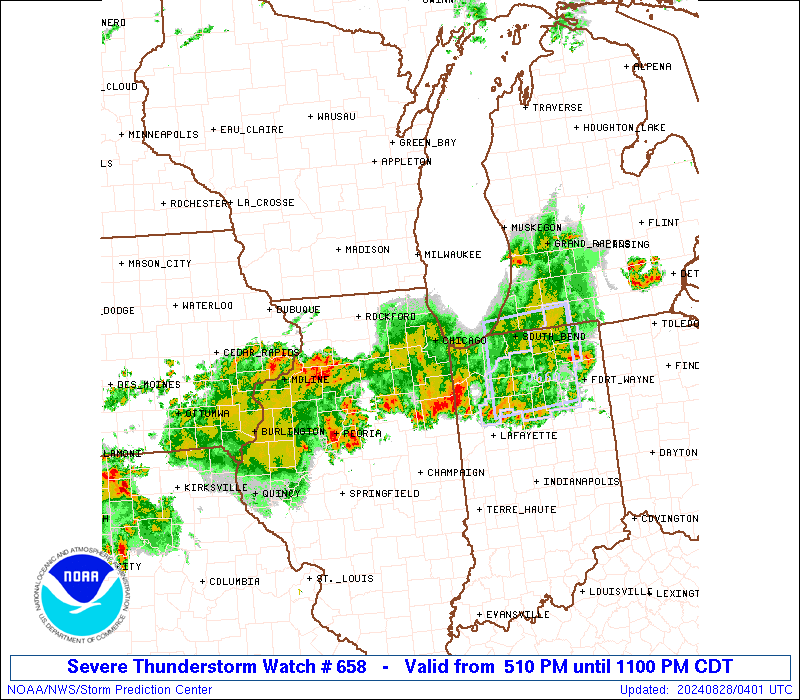
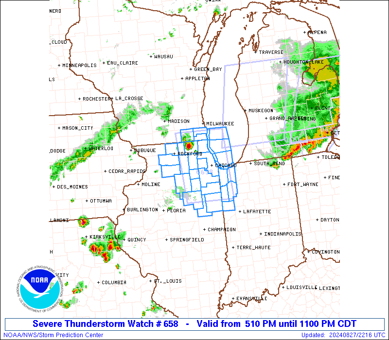
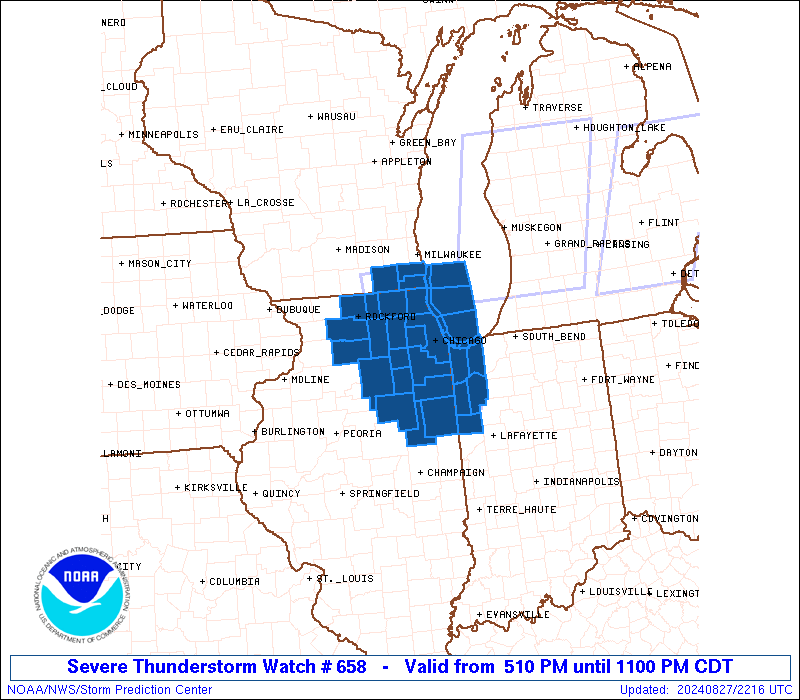
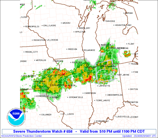
Severe Thunderstorm Watch Number 658
NWS Storm Prediction Center Norman OK
510 PM CDT Tue Aug 27 2024
The NWS Storm Prediction Center has issued a
* Severe Thunderstorm Watch for portions of
Northern Illinois
Northwest Indiana
Far Southeast Wisconsin
Lake Michigan
* Effective this Tuesday afternoon and evening from 510 PM until
1100 PM CDT.
* Primary threats include...
Scattered damaging winds and isolated significant gusts to 75
mph possible
Scattered large hail and isolated very large hail events to 2
inches in diameter possible
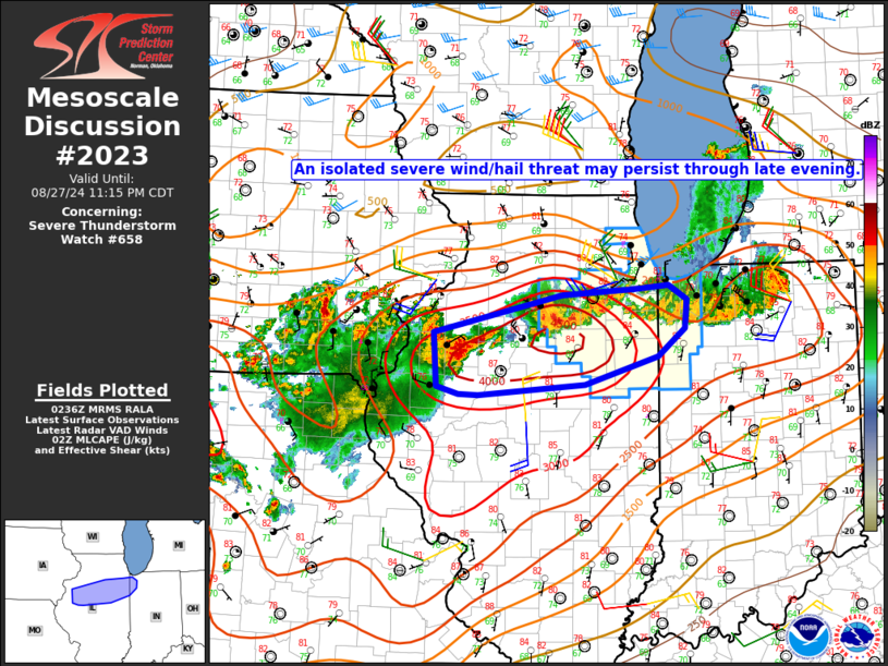
SUMMARY...Thunderstorms should continue to grow in coverage and
intensity this afternoon and evening as they move
east-southeastward. Large hail around 1-2 inches in diameter will be
a threat with any supercells, but severe/damaging winds generally
around 60-70 mph may also occur if thunderstorms can grow into a
small cluster.
The severe thunderstorm watch area is approximately along and 45
statute miles east and west of a line from 15 miles west of Racine
WI to 55 miles southeast of Marseilles IL. For a complete depiction
of the watch see the associated watch outline update (WOUS64 KWNS
WOU8).
PRECAUTIONARY/PREPAREDNESS ACTIONS...
REMEMBER...A Severe Thunderstorm Watch means conditions are
favorable for severe thunderstorms in and close to the watch area.
Persons in these areas should be on the lookout for threatening
weather conditions and listen for later statements and possible
warnings. Severe thunderstorms can and occasionally do produce
tornadoes.
&&
OTHER WATCH INFORMATION...CONTINUE...WW 656...WW 657...
AVIATION...A few severe thunderstorms with hail surface and aloft to
2 inches. Extreme turbulence and surface wind gusts to 65 knots. A
few cumulonimbi with maximum tops to 500. Mean storm motion vector
30025.
...Gleason

   SEL8

   URGENT - IMMEDIATE BROADCAST REQUESTED
   Severe Thunderstorm Watch Number 658
   NWS Storm Prediction Center Norman OK
   510 PM CDT Tue Aug 27 2024

   The NWS Storm Prediction Center has issued a

   * Severe Thunderstorm Watch for portions of
     Northern Illinois
     Northwest Indiana
     Far Southeast Wisconsin
     Lake Michigan

   * Effective this Tuesday afternoon and evening from 510 PM until
     1100 PM CDT.

   * Primary threats include...
     Scattered damaging winds and isolated significant gusts to 75
       mph possible
     Scattered large hail and isolated very large hail events to 2
       inches in diameter possible

   SUMMARY...Thunderstorms should continue to grow in coverage and
   intensity this afternoon and evening as they move
   east-southeastward. Large hail around 1-2 inches in diameter will be
   a threat with any supercells, but severe/damaging winds generally
   around 60-70 mph may also occur if thunderstorms can grow into a
   small cluster.

   The severe thunderstorm watch area is approximately along and 45
   statute miles east and west of a line from 15 miles west of Racine
   WI to 55 miles southeast of Marseilles IL. For a complete depiction
   of the watch see the associated watch outline update (WOUS64 KWNS
   WOU8).

   PRECAUTIONARY/PREPAREDNESS ACTIONS...

   REMEMBER...A Severe Thunderstorm Watch means conditions are
   favorable for severe thunderstorms in and close to the watch area.
   Persons in these areas should be on the lookout for threatening
   weather conditions and listen for later statements and possible
   warnings. Severe thunderstorms can and occasionally do produce
   tornadoes.

   &&

   OTHER WATCH INFORMATION...CONTINUE...WW 656...WW 657...

   AVIATION...A few severe thunderstorms with hail surface and aloft to
   2 inches. Extreme turbulence and surface wind gusts to 65 knots. A
   few cumulonimbi with maximum tops to 500. Mean storm motion vector
   30025.

   ...Gleason
 Note:
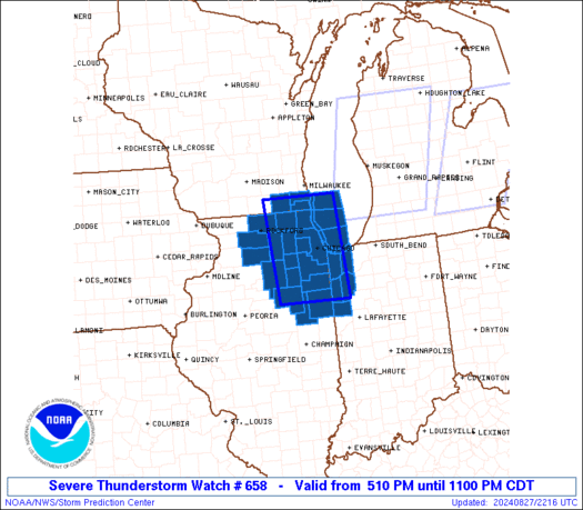
The Aviation Watch (SAW) product is an approximation to the watch area.
The actual watch is depicted by the shaded areas.
Note:
The Aviation Watch (SAW) product is an approximation to the watch area.
The actual watch is depicted by the shaded areas.
   SAW8
   WW 658 SEVERE TSTM IL IN WI LM 272210Z - 280400Z
   AXIS..45 STATUTE MILES EAST AND WEST OF LINE..
   15W RAC/RACINE WI/ - 55SE MMO/MARSEILLES IL/
   ..AVIATION COORDS.. 40NM E/W /23SSE BAE - 42WNW BVT/
   HAIL SURFACE AND ALOFT..2 INCHES. WIND GUSTS..65 KNOTS.
   MAX TOPS TO 500. MEAN STORM MOTION VECTOR 30025.

   LAT...LON 42768722 40808708 40808880 42768899

   THIS IS AN APPROXIMATION TO THE WATCH AREA.  FOR A
   COMPLETE DEPICTION OF THE WATCH SEE WOUS64 KWNS
   FOR WOU8.
Watch 658 Status Report Messages:
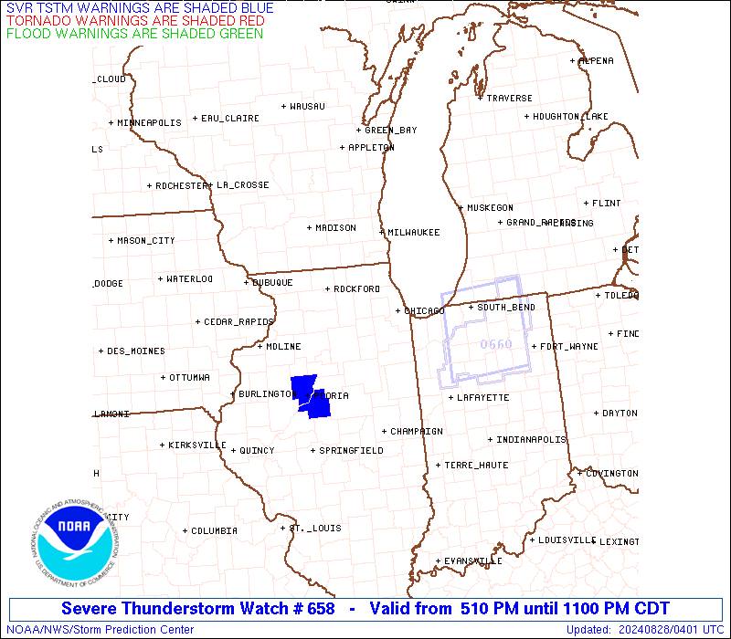
STATUS REPORT #4 ON WW 658

VALID 280330Z - 280400Z

SEVERE WEATHER THREAT CONTINUES RIGHT OF A LINE FROM 30 W MMO TO
5 E VPZ.

WW 658 WILL BE ALLOWED TO EXPIRE AT 280400Z.

FOR ADDITIONAL INFORMATION SEE MESOSCALE DISCUSSION 2023

..DEAN..08/28/24

ATTN...WFO...LOT...MKX...

&&

STATUS REPORT FOR WS 658

SEVERE WEATHER THREAT CONTINUES FOR THE FOLLOWING AREAS

ILC053-063-075-091-099-105-197-280400-

IL
.    ILLINOIS COUNTIES INCLUDED ARE

FORD		     GRUNDY		 IROQUOIS
KANKAKEE	     LA SALLE		 LIVINGSTON
WILL
$$


INC007-073-089-111-127-280400-

IN
.    INDIANA COUNTIES INCLUDED ARE

BENTON		     JASPER		 LAKE
NEWTON		     PORTER
$$


THE WATCH STATUS MESSAGE IS FOR GUIDANCE PURPOSES ONLY.  PLEASE
REFER TO WATCH COUNTY NOTIFICATION STATEMENTS FOR OFFICIAL
INFORMATION ON COUNTIES...INDEPENDENT CITIES AND MARINE ZONES
CLEARED FROM SEVERE THUNDERSTORM AND TORNADO WATCHES.
$$

STATUS REPORT #3 ON WW 658

VALID 280245Z - 280340Z

SEVERE WEATHER THREAT CONTINUES RIGHT OF A LINE FROM 30 WNW MMO
TO 15 W BEH.

FOR ADDITIONAL INFORMATION SEE MESOSCALE DISCUSSION 2023

..DEAN..08/28/24

ATTN...WFO...LOT...MKX...

&&

STATUS REPORT FOR WS 658

SEVERE WEATHER THREAT CONTINUES FOR THE FOLLOWING AREAS

ILC053-063-075-091-093-099-105-197-280340-

IL
.    ILLINOIS COUNTIES INCLUDED ARE

FORD		     GRUNDY		 IROQUOIS
KANKAKEE	     KENDALL		 LA SALLE
LIVINGSTON	     WILL
$$


INC007-073-089-111-127-280340-

IN
.    INDIANA COUNTIES INCLUDED ARE

BENTON		     JASPER		 LAKE
NEWTON		     PORTER
$$


THE WATCH STATUS MESSAGE IS FOR GUIDANCE PURPOSES ONLY.  PLEASE
REFER TO WATCH COUNTY NOTIFICATION STATEMENTS FOR OFFICIAL
INFORMATION ON COUNTIES...INDEPENDENT CITIES AND MARINE ZONES
CLEARED FROM SEVERE THUNDERSTORM AND TORNADO WATCHES.
$$

STATUS REPORT #2 ON WW 658

VALID 280015Z - 280140Z

SEVERE WEATHER THREAT CONTINUES RIGHT OF A LINE FROM 5 WSW JVL TO
40 NW BEH.

FOR ADDITIONAL INFORMATION SEE MESOSCALE DISCUSSION 2020

..DEAN..08/28/24

ATTN...WFO...LOT...MKX...

&&

STATUS REPORT FOR WS 658

SEVERE WEATHER THREAT CONTINUES FOR THE FOLLOWING AREAS

ILC007-031-037-043-053-063-075-089-091-093-097-099-103-105-111-
141-197-201-280140-

IL
.    ILLINOIS COUNTIES INCLUDED ARE

BOONE		     COOK		 DE KALB
DUPAGE		     FORD		 GRUNDY
IROQUOIS	     KANE		 KANKAKEE
KENDALL 	     LAKE		 LA SALLE
LEE		     LIVINGSTON 	 MCHENRY
OGLE		     WILL		 WINNEBAGO
$$


INC007-073-089-111-127-280140-

IN
.    INDIANA COUNTIES INCLUDED ARE

BENTON		     JASPER		 LAKE
NEWTON		     PORTER
$$


LMZ740-741-742-743-744-745-777-779-280140-

CW

.    ADJACENT COASTAL WATERS INCLUDED ARE

WINTHROP HARBOR TO WILMETTE HARBOR IL

WILMETTE HARBOR TO NORTHERLY ISLAND IL

NORTHERLY ISLAND TO CALUMET HARBOR IL

CALUMET HARBOR IL TO GARY IN

GARY TO BURNS HARBOR IN

BURNS HARBOR TO MICHIGAN CITY IN

LAKE MICHIGAN FROM WINTHROP HARBOR TO WILMETTE HARBOR IL 5NM
OFFSHORE TO MID LAKE

LAKE MICHIGAN FROM WILMETTE HARBOR TO MICHIGAN CITY IN 5NM
OFFSHORE TO MID LAKE

$$
THE WATCH STATUS MESSAGE IS FOR GUIDANCE PURPOSES ONLY.  PLEASE
REFER TO WATCH COUNTY NOTIFICATION STATEMENTS FOR OFFICIAL
INFORMATION ON COUNTIES...INDEPENDENT CITIES AND MARINE ZONES
CLEARED FROM SEVERE THUNDERSTORM AND TORNADO WATCHES.
$$

STATUS REPORT #1 ON WW 658

VALID 272240Z - 272340Z

THE SEVERE WEATHER THREAT CONTINUES ACROSS THE ENTIRE WATCH AREA.

..DEAN..08/27/24

ATTN...WFO...LOT...MKX...

&&

STATUS REPORT FOR WS 658

SEVERE WEATHER THREAT CONTINUES FOR THE FOLLOWING AREAS

ILC007-031-037-043-053-063-075-089-091-093-097-099-103-105-111-
141-197-201-272340-

IL
.    ILLINOIS COUNTIES INCLUDED ARE

BOONE		     COOK		 DE KALB
DUPAGE		     FORD		 GRUNDY
IROQUOIS	     KANE		 KANKAKEE
KENDALL 	     LAKE		 LA SALLE
LEE		     LIVINGSTON 	 MCHENRY
OGLE		     WILL		 WINNEBAGO
$$


INC007-073-089-111-127-272340-

IN
.    INDIANA COUNTIES INCLUDED ARE

BENTON		     JASPER		 LAKE
NEWTON		     PORTER
$$


WIC059-101-127-272340-

WI
.    WISCONSIN COUNTIES INCLUDED ARE

KENOSHA 	     RACINE		 WALWORTH
$$


LMZ646-675-740-741-742-743-744-745-777-779-272340-

CW

.    ADJACENT COASTAL WATERS INCLUDED ARE

WIND POINT WI TO WINTHROP HARBOR IL

LAKE MICHIGAN FROM WIND POINT WI TO WINTHROP HARBOR IL 5NM
OFFSHORE TO MID LAKE

WINTHROP HARBOR TO WILMETTE HARBOR IL

WILMETTE HARBOR TO NORTHERLY ISLAND IL

NORTHERLY ISLAND TO CALUMET HARBOR IL

CALUMET HARBOR IL TO GARY IN

GARY TO BURNS HARBOR IN

BURNS HARBOR TO MICHIGAN CITY IN

LAKE MICHIGAN FROM WINTHROP HARBOR TO WILMETTE HARBOR IL 5NM
OFFSHORE TO MID LAKE

LAKE MICHIGAN FROM WILMETTE HARBOR TO MICHIGAN CITY IN 5NM
OFFSHORE TO MID LAKE

$$
THE WATCH STATUS MESSAGE IS FOR GUIDANCE PURPOSES ONLY.  PLEASE
REFER TO WATCH COUNTY NOTIFICATION STATEMENTS FOR OFFICIAL
INFORMATION ON COUNTIES...INDEPENDENT CITIES AND MARINE ZONES
CLEARED FROM SEVERE THUNDERSTORM AND TORNADO WATCHES.
$$
Note:
Click for Complete Product Text.
Tornadoes
Probability of 2 or more tornadoes
|
Low (10%)
|
Probability of 1 or more strong (EF2-EF5) tornadoes
|
Low (5%)
|
Wind
Probability of 10 or more severe wind events
|
Mod (40%)
|
Probability of 1 or more wind events > 65 knots
|
Mod (30%)
|
Hail
Probability of 10 or more severe hail events
|
Mod (40%)
|
Probability of 1 or more hailstones > 2 inches
|
Mod (30%)
|
Combined Severe Hail/Wind
Probability of 6 or more combined severe hail/wind events
|
High (70%)
|
For each watch, probabilities for particular events inside the watch
(listed above in each table) are determined by the issuing forecaster.
The "Low" category contains probability values ranging from less than 2%
to 20% (EF2-EF5 tornadoes), less than 5% to 20% (all other probabilities),
"Moderate" from 30% to 60%, and "High" from 70% to greater than 95%.
High values are bolded and lighter in color to provide awareness of
an increased threat for a particular event.


 @NWSSPC