 Note:
The expiration time in the watch graphic is amended if the watch is
replaced, cancelled or extended.
Note:
Note:
The expiration time in the watch graphic is amended if the watch is
replaced, cancelled or extended.
Note: Click for
Watch Status Reports.
SEL3
URGENT - IMMEDIATE BROADCAST REQUESTED
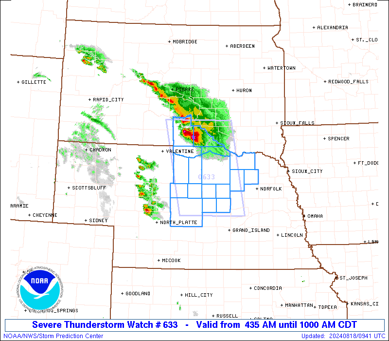
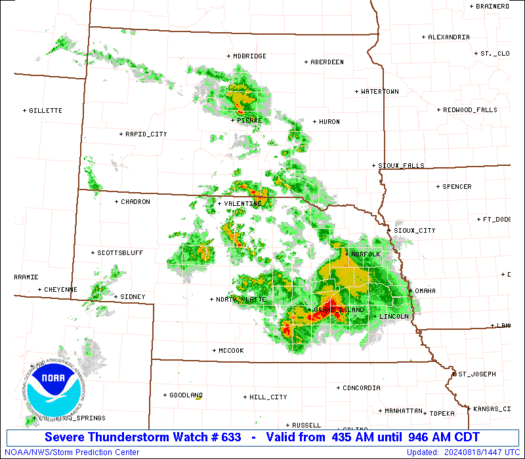
Severe Thunderstorm Watch Number 633
NWS Storm Prediction Center Norman OK
435 AM CDT Sun Aug 18 2024
The NWS Storm Prediction Center has issued a
* Severe Thunderstorm Watch for portions of
Central and Northeast Nebraska
Southern South Dakota
* Effective this Sunday morning from 435 AM until 1000 AM CDT.
* Primary threats include...
Isolated significant damaging wind gusts to 75 mph possible
Isolated very large hail events to 2.5 inches in diameter
possible
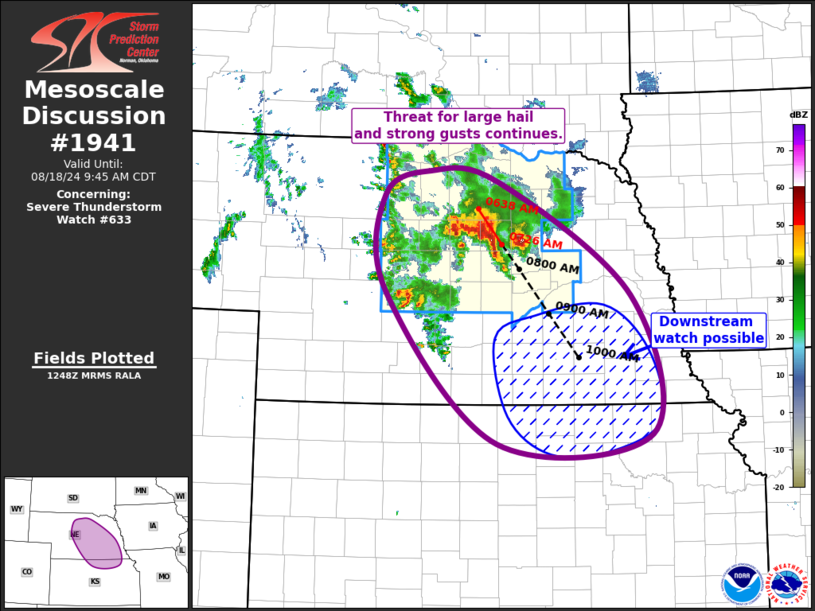
SUMMARY...Scattered elevated supercells are forecast to continue
southeast into the Watch area this morning. Large to very large
hail (1 to 2.5 inches in diameter) and severe gusts (60-75 mph) are
possible with the stronger storms as this activity moves southeast
along an instability gradient in advance of a mid-level disturbance.
The severe thunderstorm watch area is approximately along and 55
statute miles east and west of a line from 80 miles north northeast
of Ainsworth NE to 35 miles south southeast of Burwell NE. For a
complete depiction of the watch see the associated watch outline
update (WOUS64 KWNS WOU3).
PRECAUTIONARY/PREPAREDNESS ACTIONS...
REMEMBER...A Severe Thunderstorm Watch means conditions are
favorable for severe thunderstorms in and close to the watch area.
Persons in these areas should be on the lookout for threatening
weather conditions and listen for later statements and possible
warnings. Severe thunderstorms can and occasionally do produce
tornadoes.
&&
AVIATION...A few severe thunderstorms with hail surface and aloft to
2.5 inches. Extreme turbulence and surface wind gusts to 65 knots. A
few cumulonimbi with maximum tops to 550. Mean storm motion vector
32030.
...Smith
 Note:
The Aviation Watch (SAW) product is an approximation to the watch area.
The actual watch is depicted by the shaded areas.
Note:
The Aviation Watch (SAW) product is an approximation to the watch area.
The actual watch is depicted by the shaded areas.
   SAW3
   WW 633 SEVERE TSTM NE SD 180935Z - 181500Z
   AXIS..55 STATUTE MILES EAST AND WEST OF LINE..
   80NNE ANW/AINSWORTH NE/ - 35SSE BUB/BURWELL NE/
   ..AVIATION COORDS.. 50NM E/W /57SE PIR - 25W OBH/
   HAIL SURFACE AND ALOFT..2.5 INCHES. WIND GUSTS..65 KNOTS.
   MAX TOPS TO 550. MEAN STORM MOTION VECTOR 32030.

   LAT...LON 43649827 41319783 41319995 43640047

   THIS IS AN APPROXIMATION TO THE WATCH AREA.  FOR A
   COMPLETE DEPICTION OF THE WATCH SEE WOUS64 KWNS
   FOR WOU3.
Watch 633 Status Report Messages:
STATUS REPORT #2 ON WW 633

VALID 181340Z - 181440Z

SEVERE WEATHER THREAT CONTINUES RIGHT OF A LINE FROM 40 NNE LBF
TO 15 E BUB TO 20 WSW OFK TO 5 ENE OFK.

..BENTLEY..08/18/24

ATTN...WFO...OAX...LBF...GID...FSD...UNR...

&&

STATUS REPORT FOR WS 633

SEVERE WEATHER THREAT CONTINUES FOR THE FOLLOWING AREAS

NEC009-011-041-077-093-115-121-125-139-141-143-163-175-183-
181440-

NE
.    NEBRASKA COUNTIES INCLUDED ARE

BLAINE		     BOONE		 CUSTER
GREELEY 	     HOWARD		 LOUP
MERRICK 	     NANCE		 PIERCE
PLATTE		     POLK		 SHERMAN
VALLEY		     WHEELER
$$


THE WATCH STATUS MESSAGE IS FOR GUIDANCE PURPOSES ONLY.  PLEASE
REFER TO WATCH COUNTY NOTIFICATION STATEMENTS FOR OFFICIAL
INFORMATION ON COUNTIES...INDEPENDENT CITIES AND MARINE ZONES
CLEARED FROM SEVERE THUNDERSTORM AND TORNADO WATCHES.
$$

STATUS REPORT #1 ON WW 633

VALID 181215Z - 181340Z

SEVERE WEATHER THREAT CONTINUES RIGHT OF A LINE FROM 20 NNE VTN
TO 35 W YKN.

..MOSIER..08/18/24

ATTN...WFO...OAX...LBF...GID...FSD...UNR...

&&

STATUS REPORT FOR WS 633

SEVERE WEATHER THREAT CONTINUES FOR THE FOLLOWING AREAS

NEC003-009-011-015-017-041-071-077-089-093-103-107-115-121-125-
139-143-149-163-175-183-181340-

NE
.    NEBRASKA COUNTIES INCLUDED ARE

ANTELOPE	     BLAINE		 BOONE
BOYD		     BROWN		 CUSTER
GARFIELD	     GREELEY		 HOLT
HOWARD		     KEYA PAHA		 KNOX
LOUP		     MERRICK		 NANCE
PIERCE		     POLK		 ROCK
SHERMAN 	     VALLEY		 WHEELER
$$


THE WATCH STATUS MESSAGE IS FOR GUIDANCE PURPOSES ONLY.  PLEASE
REFER TO WATCH COUNTY NOTIFICATION STATEMENTS FOR OFFICIAL
INFORMATION ON COUNTIES...INDEPENDENT CITIES AND MARINE ZONES
CLEARED FROM SEVERE THUNDERSTORM AND TORNADO WATCHES.
$$
Note:
Click for Complete Product Text.
Tornadoes
Probability of 2 or more tornadoes
|
Low (<5%)
|
Probability of 1 or more strong (EF2-EF5) tornadoes
|
Low (<2%)
|
Wind
Probability of 10 or more severe wind events
|
Mod (30%)
|
Probability of 1 or more wind events > 65 knots
|
Mod (30%)
|
Hail
Probability of 10 or more severe hail events
|
Mod (30%)
|
Probability of 1 or more hailstones > 2 inches
|
Mod (30%)
|
Combined Severe Hail/Wind
Probability of 6 or more combined severe hail/wind events
|
High (70%)
|
For each watch, probabilities for particular events inside the watch
(listed above in each table) are determined by the issuing forecaster.
The "Low" category contains probability values ranging from less than 2%
to 20% (EF2-EF5 tornadoes), less than 5% to 20% (all other probabilities),
"Moderate" from 30% to 60%, and "High" from 70% to greater than 95%.
High values are bolded and lighter in color to provide awareness of
an increased threat for a particular event.


 @NWSSPC