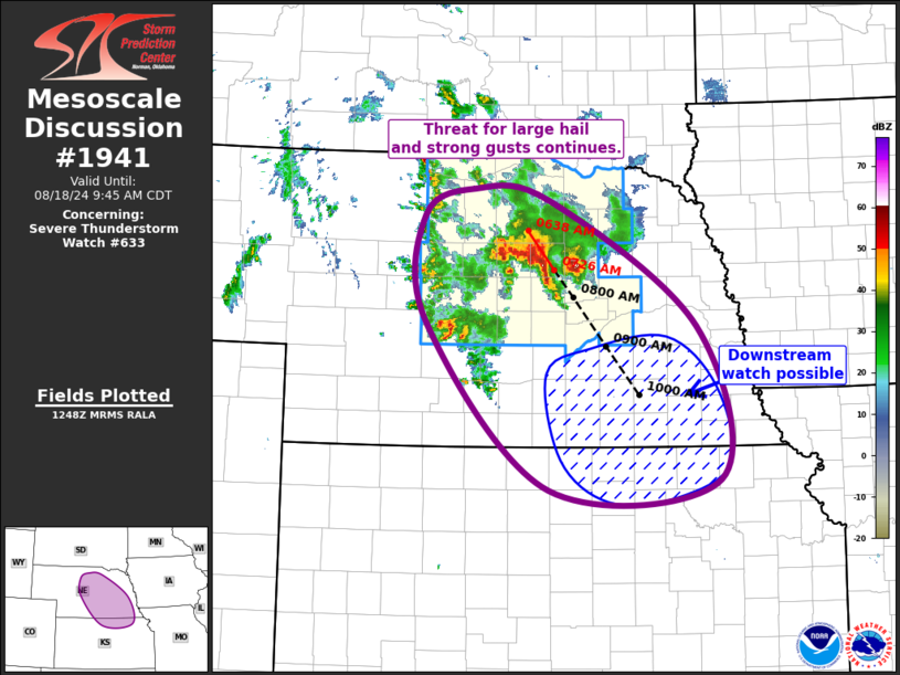
   Mesoscale Discussion 1941
   NWS Storm Prediction Center Norman OK
   0751 AM CDT Sun Aug 18 2024

   Areas affected...Central/Southeast NE...North-Central/Northeast KS

   Concerning...Severe Thunderstorm Watch 633...

   Valid 181251Z - 181445Z

   The severe weather threat for Severe Thunderstorm Watch 633
   continues.

   SUMMARY...Threat for large hail and strong gusts continues across
   central Nebraska. This threat may continue into southeast Nebraska
   and north-central/northeast Kansas and downstream watch may be
   needed.

   DISCUSSION...Despite becoming displaced further east of the primary
   low-level jet axis, the cluster (which now consists of two primary
   supercells) across central NE has persisted and perhaps even
   strengthened. This likely results from a combination of mature storm
   organization, increasing large-scale ascent, and continued mid-level
   warm-air advection.  Current storm motion of the two supercells is
   southeasterly at 30 to 35 kt, which brings them to the edge of
   Severe Thunderstorm Watch 633 at around 1430Z. However, there is
   some chance these storms begin progressing faster, as the system
   becoming increasingly linear.

   This cluster is expected to continue southeastward along the
   northern gradient of the corridor of buoyancy extending from central
   KS into western SD. Low-level stability may persist ahead of this
   cluster for at least the next several hours, but the trends over the
   past hour suggest this cluster is likely mature enough to maintain
   its strength. As such, large hail and strong gusts remain possible.
   Given the persisting low-level stability, the longevity is
   uncertain, but trends suggest a downstream watch may be needed into
   southeast NE and adjacent north-central/northeast KS.

   ..Mosier/Smith.. 08/18/2024

   ...Please see www.spc.noaa.gov for graphic product...

   ATTN...WFO...OAX...TOP...GID...LBF...

   LAT...LON   39559851 41260017 42360019 42649952 42519850 41229650
               39669621 39559851
|


 @NWSSPC