Note:
The expiration time in the watch graphic is amended if the watch is
replaced, cancelled or extended.
Note:
Note:
The expiration time in the watch graphic is amended if the watch is
replaced, cancelled or extended.
Note: Click for
Watch Status Reports.
SEL0
URGENT - IMMEDIATE BROADCAST REQUESTED
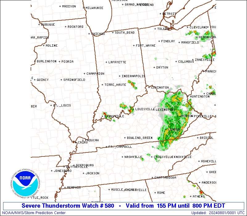
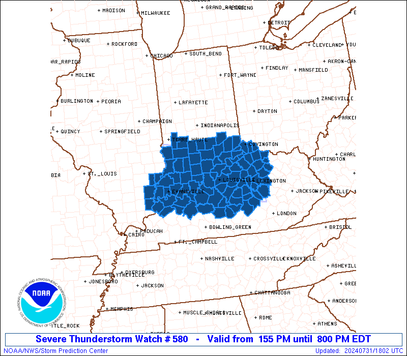
Severe Thunderstorm Watch Number 580
NWS Storm Prediction Center Norman OK
155 PM EDT Wed Jul 31 2024
The NWS Storm Prediction Center has issued a
* Severe Thunderstorm Watch for portions of
Far Southeast Illinois
Southern Indiana
Western and Central Kentucky
* Effective this Wednesday afternoon and evening from 155 PM
until 800 PM EDT.
* Primary threats include...
Scattered damaging wind gusts to 70 mph likely
SUMMARY...A developing cluster of thunderstorms should continue to
strengthen and pose a threat for mainly severe/damaging winds up to
55-70 mph as it moves east-southeastward this afternoon and early
evening.
The severe thunderstorm watch area is approximately along and 50
statute miles north and south of a line from 40 miles north of
Evansville IN to 20 miles east northeast of Lexington KY. For a
complete depiction of the watch see the associated watch outline
update (WOUS64 KWNS WOU0).
PRECAUTIONARY/PREPAREDNESS ACTIONS...
REMEMBER...A Severe Thunderstorm Watch means conditions are
favorable for severe thunderstorms in and close to the watch area.
Persons in these areas should be on the lookout for threatening
weather conditions and listen for later statements and possible
warnings. Severe thunderstorms can and occasionally do produce
tornadoes.
&&
OTHER WATCH INFORMATION...CONTINUE...WW 579...
AVIATION...A few severe thunderstorms with hail surface and aloft to
1 inch. Extreme turbulence and surface wind gusts to 60 knots. A few
cumulonimbi with maximum tops to 500. Mean storm motion vector
30035.
...Gleason
 Note:
The Aviation Watch (SAW) product is an approximation to the watch area.
The actual watch is depicted by the shaded areas.
Note:
The Aviation Watch (SAW) product is an approximation to the watch area.
The actual watch is depicted by the shaded areas.
   SAW0
   WW 580 SEVERE TSTM IL IN KY 311755Z - 010000Z
   AXIS..50 STATUTE MILES NORTH AND SOUTH OF LINE..
   40N EVV/EVANSVILLE IN/ - 20ENE LEX/LEXINGTON KY/
   ..AVIATION COORDS.. 45NM N/S /42NNE PXV - 57SSE CVG/
   HAIL SURFACE AND ALOFT..1 INCH. WIND GUSTS..60 KNOTS.
   MAX TOPS TO 500. MEAN STORM MOTION VECTOR 30035.

   LAT...LON 39338753 38868426 37418426 37898753

   THIS IS AN APPROXIMATION TO THE WATCH AREA.  FOR A
   COMPLETE DEPICTION OF THE WATCH SEE WOUS64 KWNS
   FOR WOU0.
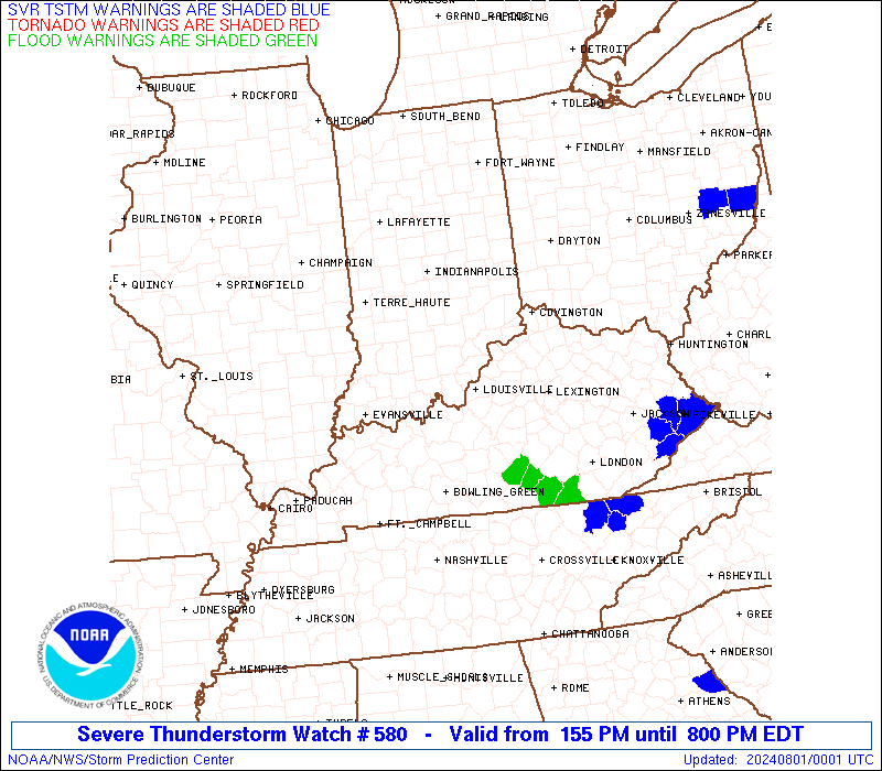
Watch 580 Status Report Messages:
STATUS REPORT #3 ON WW 580
VALID 312050Z - 312140Z
SEVERE WEATHER THREAT CONTINUES RIGHT OF A LINE FROM 25 WNW BWG
TO 45 E OWB TO 15 NW SDF TO 35 ESE IND.
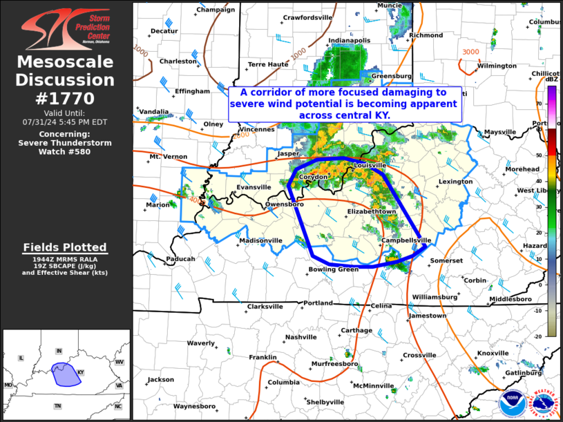
FOR ADDITIONAL INFORMATION SEE MESOSCALE DISCUSSION 1770
..MOORE..07/31/24
ATTN...WFO...PAH...IND...LMK...ILN...
&&
STATUS REPORT FOR WS 580
SEVERE WEATHER THREAT CONTINUES FOR THE FOLLOWING AREAS
INC019-029-031-043-077-079-115-137-143-155-312140-
IN
. INDIANA COUNTIES INCLUDED ARE
CLARK DEARBORN DECATUR
FLOYD JEFFERSON JENNINGS
OHIO RIPLEY SCOTT
SWITZERLAND
$$
KYC005-015-017-021-023-029-037-041-045-049-067-073-077-079-081-
085-087-093-097-099-103-111-113-117-123-137-151-155-163-167-179-
181-185-187-191-201-209-211-215-217-223-229-239-312140-
KY
. KENTUCKY COUNTIES INCLUDED ARE
ANDERSON BOONE BOURBON
BOYLE BRACKEN BULLITT
CAMPBELL CARROLL CASEY
CLARK FAYETTE FRANKLIN
GALLATIN GARRARD GRANT
GRAYSON GREEN HARDIN
HARRISON HART HENRY
JEFFERSON JESSAMINE KENTON
LARUE LINCOLN MADISON
MARION MEADE MERCER
NELSON NICHOLAS OLDHAM
OWEN PENDLETON ROBERTSON
SCOTT SHELBY SPENCER
TAYLOR TRIMBLE WASHINGTON
WOODFORD
$$
THE WATCH STATUS MESSAGE IS FOR GUIDANCE PURPOSES ONLY. PLEASE
REFER TO WATCH COUNTY NOTIFICATION STATEMENTS FOR OFFICIAL
INFORMATION ON COUNTIES...INDEPENDENT CITIES AND MARINE ZONES
CLEARED FROM SEVERE THUNDERSTORM AND TORNADO WATCHES.
$$
STATUS REPORT #2 ON WW 580
VALID 311955Z - 312040Z
SEVERE WEATHER THREAT CONTINUES RIGHT OF A LINE FROM 25 ENE MDH
TO 30 WNW SDF TO 25 SE IND.
FOR ADDITIONAL INFORMATION SEE MESOSCALE DISCUSSION 1770
..MOORE..07/31/24
ATTN...WFO...PAH...IND...LMK...ILN...
&&
STATUS REPORT FOR WS 580
SEVERE WEATHER THREAT CONTINUES FOR THE FOLLOWING AREAS
ILC059-312040-
IL
. ILLINOIS COUNTIES INCLUDED ARE
GALLATIN
$$
INC005-019-029-031-043-061-077-079-115-123-129-137-143-147-155-
163-173-175-312040-
IN
. INDIANA COUNTIES INCLUDED ARE
BARTHOLOMEW CLARK DEARBORN
DECATUR FLOYD HARRISON
JEFFERSON JENNINGS OHIO
PERRY POSEY RIPLEY
SCOTT SPENCER SWITZERLAND
VANDERBURGH WARRICK WASHINGTON
$$
KYC005-015-017-021-023-027-029-037-041-045-049-059-067-073-077-
079-081-085-087-091-093-097-099-101-103-111-113-117-123-137-149-
151-155-163-167-179-181-183-185-187-191-201-209-211-215-217-223-
225-229-233-239-312040-
KY
. KENTUCKY COUNTIES INCLUDED ARE
ANDERSON BOONE BOURBON
BOYLE BRACKEN BRECKINRIDGE
BULLITT CAMPBELL CARROLL
CASEY CLARK DAVIESS
FAYETTE FRANKLIN GALLATIN
GARRARD GRANT GRAYSON
GREEN HANCOCK HARDIN
HARRISON HART HENDERSON
HENRY JEFFERSON JESSAMINE
KENTON LARUE LINCOLN
MCLEAN MADISON MARION
MEADE MERCER NELSON
NICHOLAS OHIO OLDHAM
OWEN PENDLETON ROBERTSON
SCOTT SHELBY SPENCER
TAYLOR TRIMBLE UNION
WASHINGTON WEBSTER WOODFORD
$$
THE WATCH STATUS MESSAGE IS FOR GUIDANCE PURPOSES ONLY. PLEASE
REFER TO WATCH COUNTY NOTIFICATION STATEMENTS FOR OFFICIAL
INFORMATION ON COUNTIES...INDEPENDENT CITIES AND MARINE ZONES
CLEARED FROM SEVERE THUNDERSTORM AND TORNADO WATCHES.
$$
STATUS REPORT #1 ON WW 580
VALID 311855Z - 311940Z
SEVERE WEATHER THREAT CONTINUES RIGHT OF A LINE FROM 50 SSE MTO
TO 35 WSW BMG TO 15 WSW IND.
..MOORE..07/31/24
ATTN...WFO...PAH...IND...LMK...ILN...
&&
STATUS REPORT FOR WS 580
SEVERE WEATHER THREAT CONTINUES FOR THE FOLLOWING AREAS
ILC047-059-185-193-311940-
IL
. ILLINOIS COUNTIES INCLUDED ARE
EDWARDS GALLATIN WABASH
WHITE
$$
INC005-013-019-025-027-029-031-037-043-051-055-061-071-077-079-
083-093-101-105-115-117-119-123-125-129-137-143-147-155-163-173-
175-311940-
IN
. INDIANA COUNTIES INCLUDED ARE
BARTHOLOMEW BROWN CLARK
CRAWFORD DAVIESS DEARBORN
DECATUR DUBOIS FLOYD
GIBSON GREENE HARRISON
JACKSON JEFFERSON JENNINGS
KNOX LAWRENCE MARTIN
MONROE OHIO ORANGE
OWEN PERRY PIKE
POSEY RIPLEY SCOTT
SPENCER SWITZERLAND VANDERBURGH
WARRICK WASHINGTON
$$
KYC005-015-017-021-023-027-029-037-041-045-049-059-067-073-077-
079-081-085-087-091-093-097-099-101-103-111-113-117-123-137-149-
151-155-163-167-179-181-183-185-187-191-201-209-211-215-217-223-
225-229-233-239-311940-
KY
. KENTUCKY COUNTIES INCLUDED ARE
ANDERSON BOONE BOURBON
BOYLE BRACKEN BRECKINRIDGE
BULLITT CAMPBELL CARROLL
CASEY CLARK DAVIESS
FAYETTE FRANKLIN GALLATIN
GARRARD GRANT GRAYSON
GREEN HANCOCK HARDIN
HARRISON HART HENDERSON
HENRY JEFFERSON JESSAMINE
KENTON LARUE LINCOLN
MCLEAN MADISON MARION
MEADE MERCER NELSON
NICHOLAS OHIO OLDHAM
OWEN PENDLETON ROBERTSON
SCOTT SHELBY SPENCER
TAYLOR TRIMBLE UNION
WASHINGTON WEBSTER WOODFORD
$$
THE WATCH STATUS MESSAGE IS FOR GUIDANCE PURPOSES ONLY. PLEASE
REFER TO WATCH COUNTY NOTIFICATION STATEMENTS FOR OFFICIAL
INFORMATION ON COUNTIES...INDEPENDENT CITIES AND MARINE ZONES
CLEARED FROM SEVERE THUNDERSTORM AND TORNADO WATCHES.
$$
Note:
Click for Complete Product Text.
Tornadoes
Probability of 2 or more tornadoes
|
Low (10%)
|
Probability of 1 or more strong (EF2-EF5) tornadoes
|
Low (<2%)
|
Wind
Probability of 10 or more severe wind events
|
High (70%)
|
Probability of 1 or more wind events > 65 knots
|
Low (20%)
|
Hail
Probability of 10 or more severe hail events
|
Low (10%)
|
Probability of 1 or more hailstones > 2 inches
|
Low (<5%)
|
Combined Severe Hail/Wind
Probability of 6 or more combined severe hail/wind events
|
High (80%)
|
For each watch, probabilities for particular events inside the watch
(listed above in each table) are determined by the issuing forecaster.
The "Low" category contains probability values ranging from less than 2%
to 20% (EF2-EF5 tornadoes), less than 5% to 20% (all other probabilities),
"Moderate" from 30% to 60%, and "High" from 70% to greater than 95%.
High values are bolded and lighter in color to provide awareness of
an increased threat for a particular event.


 @NWSSPC